More weather pointers for the British Isles
The purpose of this page is to bring together some of those links to meteorological information relevant to the British Isles (including the Republic of Ireland), and surrounding waters.
Have you already seen here for the most requested pointers?
Some more places to look for information:
- Latest charts
- European station plots
Useful institution sites in the British Isles
Others are mentioned in the sections that follow
- The Irish Meteorological Service
- Centre for Ecology and Hydrology (CEH); Includes data on current drought/rainfall
- European Centre for Medium-Range Weather Forecasts; Includes medium-range forecast charts
- Met Office UK; Interesting information, but not much data
- Royal Meteorological Society; The UK society for meteorologists
- Department of Meteorology, University of Reading; The place to study meteorology in the UK!
- British Antarctic Survey
- Centre for Environmental Data Analysis (CEDA); Some free data, but mostly you'll need permission from CEDA
- Climatic Research Unit, University of East Anglia
- University of Birmingham
- BBC Weather Centre
- Scottish Avalanche Information Service (SAIS), University of Glasgow
- Tornado and Storm Research Organisation
- University of Edinburgh Institute of Atmospheric and Environmental Science)
- Irish Met. Society
- Climatological Observers Link; The organisation for all UK weather observers
Alternative sources of British Isles data
- Come to UK Weather pages
- weather.org; Provided by Dave Reynolds and Dave Wheeler.
- Naval Atlantic Meteorology and Oceanography Center (Atlantic Region); [Naval Atlantic Meteorology and Oceanography Center (Atlantic Region)]
Meteorological information
Latest surface analysis charts
- NE Atlantic surface analysis; [US National Weather Service]
- Atlantic and European actual surface chart from Bracknell, ASXX EGRR - updated every 6 hours; [US National Weather Service]
- Surface Northern Hemisphere analysis 0-90W Prelim; [US National Weather Service]
Latest surface observation charts
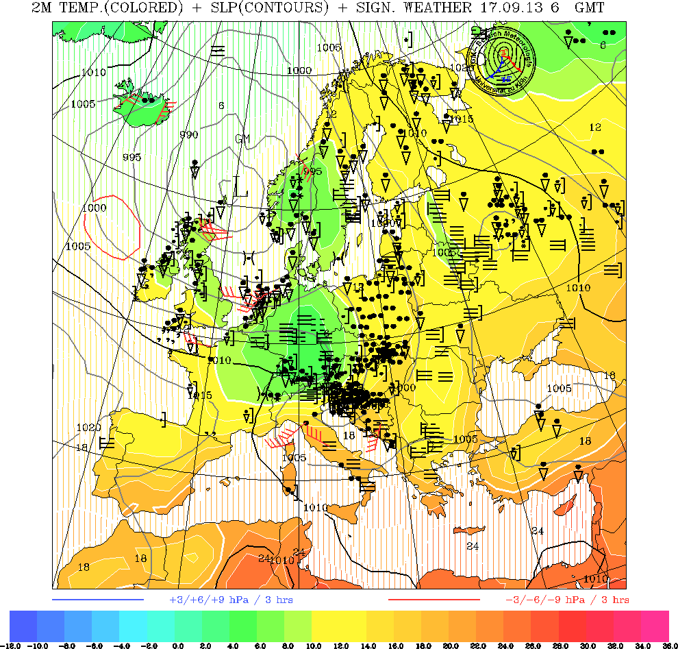
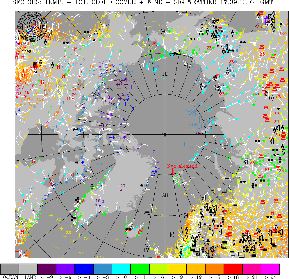
- Latest surface isotherms and isobars for Europe plus significant weather; [University of Koeln, Germany]
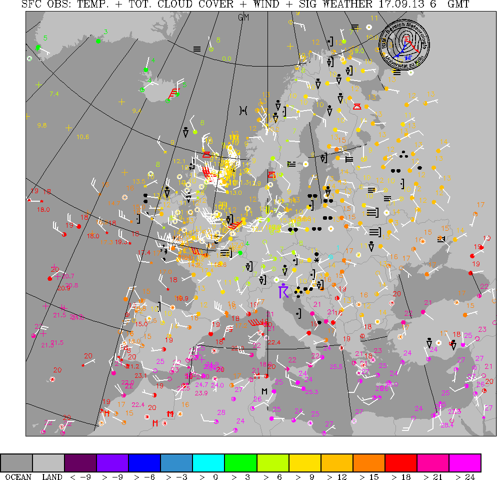
- Latest E uropean surface observations (selected cities; [University of Koeln, Germany]
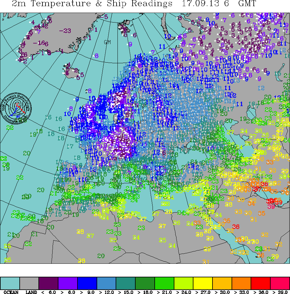
- Latest European temperature (all readings available); [University of Koeln, Germany]
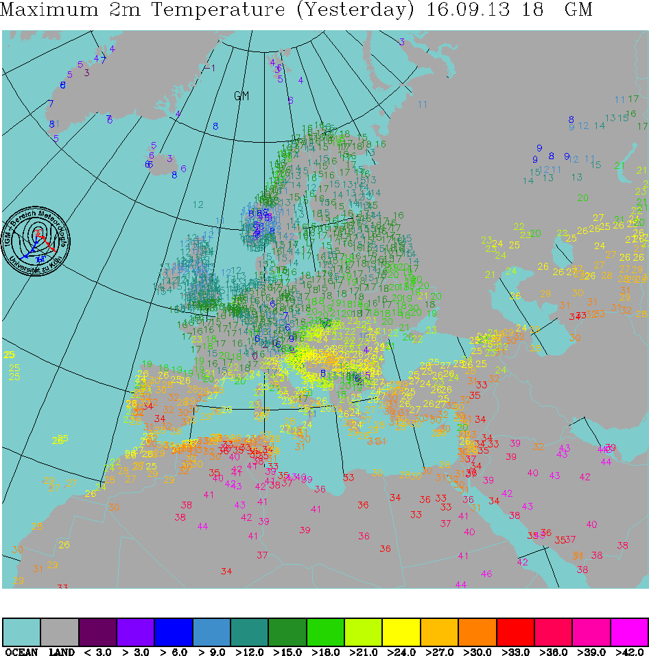
- European maximum temperatures (all readings available); [University of Koeln, Germany]
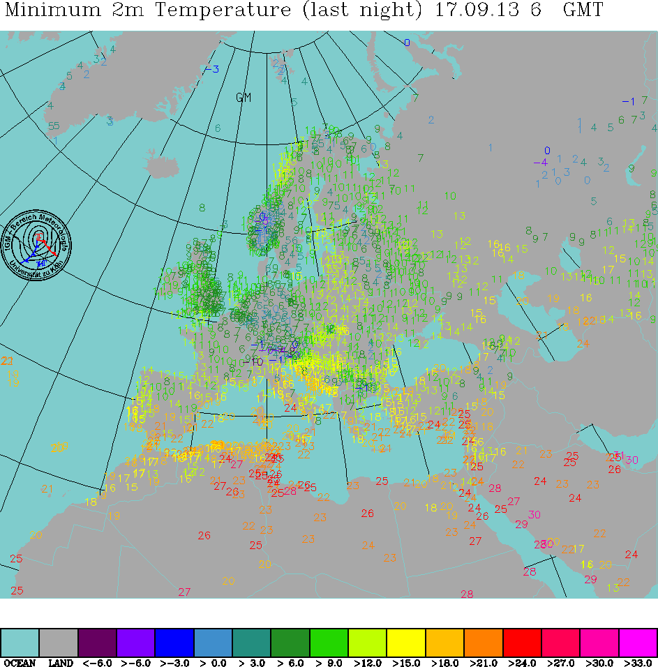
- European minimum temperature (all readings available); [University of Koeln, Germany]
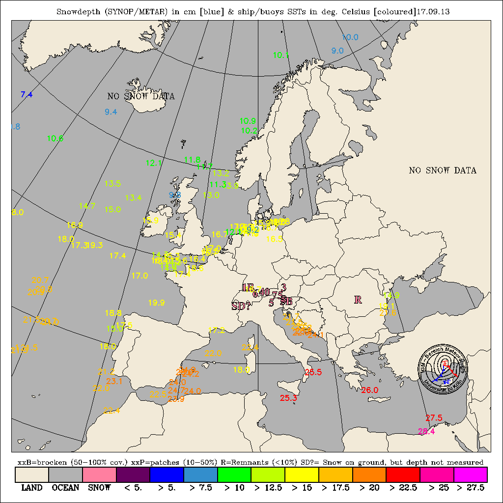
- European snow & Ship SST readings 06 GMT (all readings available); [University of Koeln, Germany]
- Latest arctic surface observations (all readings available); [University of Koeln, Germany]
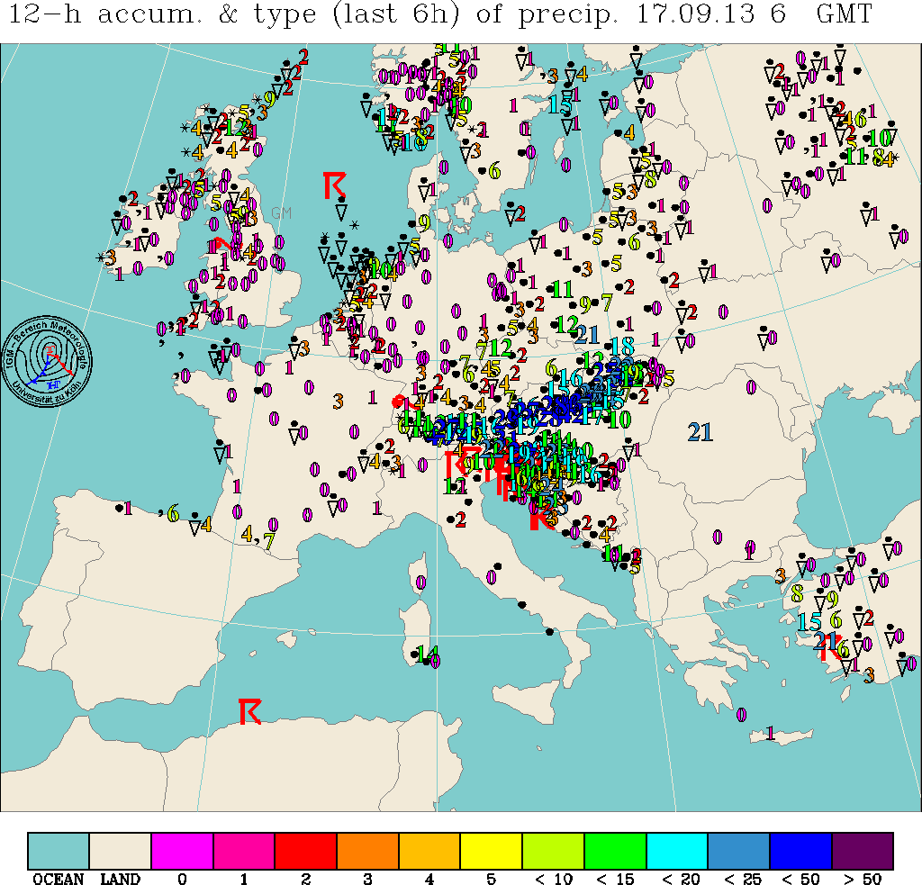
- European accumulated precipitation; [University of Koeln, Germany]
Analysed observations
- 00Z analysis 0-90W Northern Hemisphere (Part 1); [US National Weather Service]
- 06Z analysis 0-90W Northern Hemisphere (Part 1); [US National Weather Service]
- Surface analysis from 12Z; model (Part 1) 0-90W Northern Hemisphere at 00Z; [US National Weather Service]
- 18Z analysis 0-90W Northern Hemisphere (Part 1); [US National Weather Service]
500 mb analysis charts
- 00Z 500 mb analysis 0-90W Northern Hemisphere; [US National Weather Service]
Sea state analysis charts
- 1200Z Wave height sea state analysis 0-90W Northern Hemisphere Analysis; [US National Weather Service]
- Sea surface temperatures in UK and Northeast Atlantic waters; [Met Office, via US NWS]
- Sea Surface Wind/Swell Analysis North Atlantic 0-70W Sea Swell Contours; [Met Office, via US NWS]
Satellite data
- NOAA; [University of Dundee Satellite Receiving Station]
- Remote Imaging Group; [Remote Imaging Group]
MSL Pressure fcst charts
- Atlantic and European 24hr forecast surface chart from Bracknell, FSXX EGRR; [US National Weather Service]
- Atlantic and European 36hr forecast surface chart from Bracknell, FSXX EGRR; [US National Weather Service]
- 48hr Surface forecast VT 00Z 45-180 Northern Hemisphere; [US National Weather Service]
- 48hr Surface forecast VT 12Z T45-180 Northern Hemisphere; [US National Weather Service]
- Atlantic and European 60hr forecast surface chart from Bracknell, FSXX EGRR; [US National Weather Service]
- 96hr Surface forecast VT 00Z 0-90W Northern Hemisphere; [US National Weather Service]
- ECMWF analysis and 3-6 day forecast; [European Centre for Medium-Range Weather Forecasts]
500 mb forecast charts
- ECMWF analysis and 3-6 day forecast; [European Centre for Medium-Range Weather Forecasts]
- 12-hr 500mb forecast for North Atlantic; [US National Weather Service]
- 12-hr 500 mb forecast 0-90W Northern Hemisphere; [US National Weather Service]
- Latest 36-hr 500 mb forecast for N Atlantic; [US National Weather Service]
- 36-hr 500 mb forecast for N Atlantic valid 00Z; [US National Weather Service]
- 36-hr 500 mb forecast for N Atlantic valid 12Z; [US National Weather Service]
- Latest 48-hr 500 mb forecast for N Atlantic; [US National Weather Service]
- 48hr 500 mb forecast VT 00Z 0-90W Northern Hemisphere; [US National Weather Service]
- 48hr 500 mb forecast VT 12Z 0-90W Northern Hemisphere; [US National Weather Service]
- Atlantic and European 36hr forecast surface chart from Bracknell, FSXX EGRR, includes 1000-500mb thickness; [US National Weather Service]
- Atlantic and European 60hr forecast surface chart from Bracknell, FSXX EGRR, includes 1000-500mb thickness; [US National Weather Service]
- 96hr 500 mb forecast VT 00Z 0-90W Northern Hemisphere; [US National Weather Service]
Sea state forecast charts
- 48-hr sea state forecast for North Atlantic and Caribbean; [US National Weather Service]
- 48hr Sea state forecast VT00Z 0-90W Northern Hemisphere; [US National Weather Service]
- 48hr Sea state forecast VT12Z 0-90W Northern Hemisphere; [US National Weather Service]
- Sea Surface Wind/Swell 24 HR Forecast North Atlantic 0-70W Sea Swell Contours; [Met Office, via US NWS]
- Sea Swell/Wind Direction Chart 12 HR FCST North Atlantic & Caribbean Sea; [US National Weather Service]
- Sea Surface Wind/Swell 48 HR Forecast North Atlantic 0-70W Sea Swell Contours; [Met Office, via US NWS]
Sea area forecasts
- Inshore Waters Forecast; [Met Office]
- The Shipping Forecast; [Met Office]
- Gale Warnings - most recent issued; [Met Office]
Flight level information forecast charts
- Sig. weather prognosis for flight levels 250-630 over Europe and North Atlantic; [US National Weather Service]
UK weather station reports
- Across the UK; [Wunderground]
- See here also
- Current weather conditions for about 70 sites in the UK(decoded METAR reports); [US NWS]
- Current weather conditions for about 3 sites in Ireland(decoded METAR reports); [US NWS]
Radiosonde and profiler reports
- Recent decoded radiosonde data for western Europe; [University of Barcelona]
Climatological averages for the British Isles
Climatological summaries for the British Isles
Other compilations of information for the British Isles
Last updated 26 August 2020. © 2007-2020 Roger Brugge