
January 2013:
2012 wettest year on record in England
The Met Office confirmed that in 2012 England had its wettest year since records began in 1910 and the UK its 2nd wettest behin 2000 (see Met Office data for the UK and statistics for Reading). This was despite a dry first 3 months of 2012 (particularly March which ended 2 years of below average reainfall) and a relatively dry year for NW Scotland (see figure from the Met Office below).
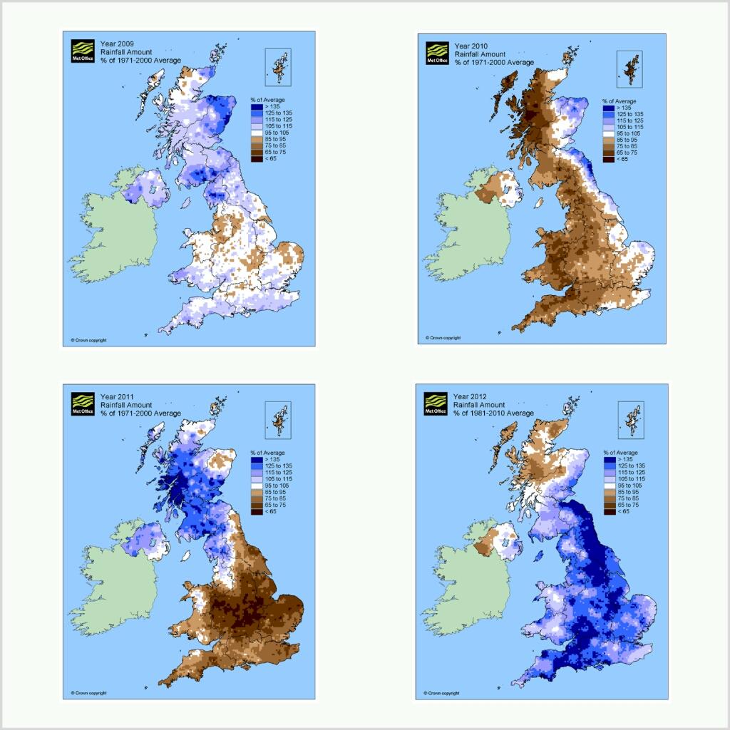
It is interesting to note that 4 of the 5 wettest years on record occurred since 2000 (while 2010 and in particular 2003 were unusually dry). December, April and (in particular) June were exceptionally wet with associated flooding associated with intense summer downpours and prolonged rainfall in the summer, early Autumn and December, resulting in flooding and disruption to transport.
Why was it so wet?
The jet stream, a ribbon of fast-moving (>160 km/hour) winds around 10km above our heads, is responsible for directing weather systems over the UK or deflecting them away from the UK. It meanders north and south over thousands of km, causing above average rain in some regions and below average in others, depending upon whether it is further north or further south than usual. For example, while the UK was enduring persistent rainfall, the north America was suffering from summer heat-waves and drought. A dramatic shift in the average position of the jet stream from March to April 2012 can broadly explain why conditions changed from that of drought to flooding in the UK.
What caused the jet stream to change and can we expect more years like 2012 in the future?
The jet stream owes its existence to a rapid decline in temperature from the warm sub-tropics to the polar regions. This temperature gradient, combined with the spin of the Earth, produce these upper level jets. Therefore, changes in this temperature gradient can certainly affect where the jet stream is and how "saggy" the loops and meanders are. Much of the variability is a result of natural fluctuations: we will always get very wet years and very dry years. This year, there were unusually warm waters in the north Atlantic, particularly off the coast of Newfoundland (see figure below).
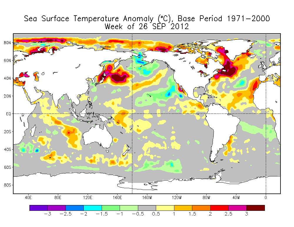
Changes in north Atlantic sea surface temperature oscillate from warm to cold over many decades and this is thought to influence weather over the UK, in particular for summer. However, an additional warming trend, relating to the build up of greenhouse gases in the atmosphere, is also having an impact on our weather, and will increasingly do so in the future as global temperatures rise.
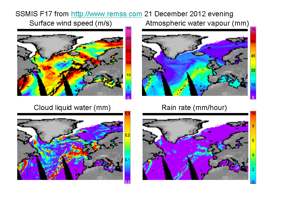
Flooding in the UK is often associated with large transports of moisture from the warm sub-tropics, referred to recently as Atmospheric Rivers. For example, microwave satellite imagery processed by REMSS shows strong winds combined with high water vapour amounts directed towards the UK on 21 December (see figure below), resulting in heavy, prolonged rainfall and further flooding.
As air temperatures increase, so does atmospheric gaseous water vapour, at the rate of around 7% for each oC of warming. This moisture is the fuel for storms which suck in this invisible water and following condensation of water doplets and formation of ice crystals, produce heavy rainfall. Therefore as moisture levels increase, so does the potential for more intense rainfall. This suggest that in the future, while we will always have wet and dry years associated with shifts in the jet stream, when it is wet, the rainfall will arrive in heavier bursts, with more flooding possible.
There are many other possible influences on our weather patters, some of which are natural, like changes in the sun or oscillations in the ocean, and some of which are strongly influenced by humans such as greenhouse gas caused increases in temperature and moisture and the melting of Arctic ice with its possible influence on ocean temperature patterns and the jet stream. However, computer simulations of the future combined with basic physics tells us that we can expect more flooding and more drought globally as a result of man-made climate warming.
Richard P. Allan Location: Department of Meteorology (2U15)
