
June 2012: Testing climate simulations of present-day rainfall variability
The global water cycle describes the movement of water in its gaseous, liquid and frozen states around the climate system: for example, evaporation over the oceans, transport of the gaseous vapour by the atmosphere, condensation as cloud with precipitation returning fresh water to the surface (rainfall, snowfall, etc) and run-off through rivers back into the oceans (see Figure below). Societies and ecosystems are highly sensitive to the availability of fresh water. Too much at once can cause damage (e.g. flooding) while too little over sustained periods of time can deplete water reserves. Damage from both have been experienced over the last year in the UK and globally: recent occurrence of extreme weather understandably heightens concern on the human influence on and vulnerability to such events.
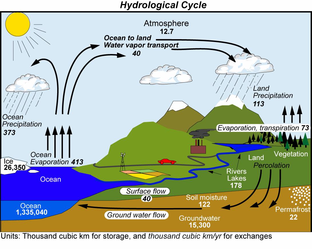 Illustration from Trenberth et al., 2007, Estimates of the global water budget and its annual cycle using observational and model data, Journal of Hydrometeorology.
One of the most concerning aspects of climate change are the changes in the water cycle that accompany sustained global warming or cooling. Based on relatively simple physics, we know that there will be more rainfall globally as temperatures warm. We also know that, on average, increased rainfall will affect the already wet equatorial regions and the higher latitude regions. Both of these regimes borrow water from further afield, while the regions that provide that water, through evaporation, for example over the dry sub-tropics, will on average experience drying trends. The latest state-of-the-art climate simulations from the 5th phase of the Coupled Model Inter-comparison Project (CMIP5) demonstrate these projected patterns which are explained quite well by simple physics.
To really build confidence in our predictions of changes in the global water cycle, the realism of simulations of climate and its variability must be established using available observations of rainfall. In a paper published in Geophysical Research Letters (lead by Chunlei Liu at the University of Reading and in collaboration with NASA/Goddard Space Flight Center) we looked in detail at how well the new CMIP5 simulations of precipitation compare with observations taken from satellite measurements and rain-gauges at the land surface. We tested two types of experiments: ones which simulate ocean variability as well as changes in the atmosphere over the last 100 or so years (the standard CMIP "historical" experiments) and another set in which the observed changes in sea surface temperature and sea ice distribution are fed in as input to atmosphere-only simulations over the period 1979-2008 (called AMIP). Both experiments are given realistic changes in climate forcing agents (e.g. carbon dioxide and reflective volcanic or human produced sulphate aerosols). The AMIP experiments are the most consistent with the observations since the natural warming and cooling cycles match the observational record. However, they don't contain ocean "feedbacks" which influence the progression of climate that are required to simulate future climate change; this is why it is important to look also at the CMIP experiments.
Our main findings were as follows:
1) Bias in the simulations: Both CMIP and AMIP simulations appear to overestimate rainfall over the tropical oceans, by between 19% and 40% depending upon which agencies simulator was used (for example, NASA Goddard Institute for Space Studies GISS-ER simulations gave the largest amount of rainfall while the French IPSL CM5A-LR were closest to the observed estimates). The biases were the largest over the wet regions of the tropical west Pacific and Indian Oceans.
2) Global Precipitation Rises with Warming: When considering the natural warming and cooling cycles, relating to the El Niño Southern Oscillation (ENSO), AMIP5 simulated increasing global precipitation of 1.6-3.6 % per oC increase in global temperature depending on which agencies simulation was considered. The CMIP5 simulations were similar but slightly lower while the observations from the Global Precipitation Climatology Project (GPCP) were at the upper end of this range.
3) The "Rich" get "Richer": The increase in precipitation with natural warming cycles originated primarily from the wet tropical ocean regions: in these regions the observed response was around 3 times larger than the simulated relationship. Over the the remainder of the tropical oceans, where less rain falls on average, both observations and simulations show a decrease in rainfall when tropical temperatures are warmer.
4) Rainfall Moves between Ocean and Land: When there is more rainfall over the ocean (during El Niño) there is less rainfall over land.
Finally, the result that I found most interesting is shown in the Figure below:
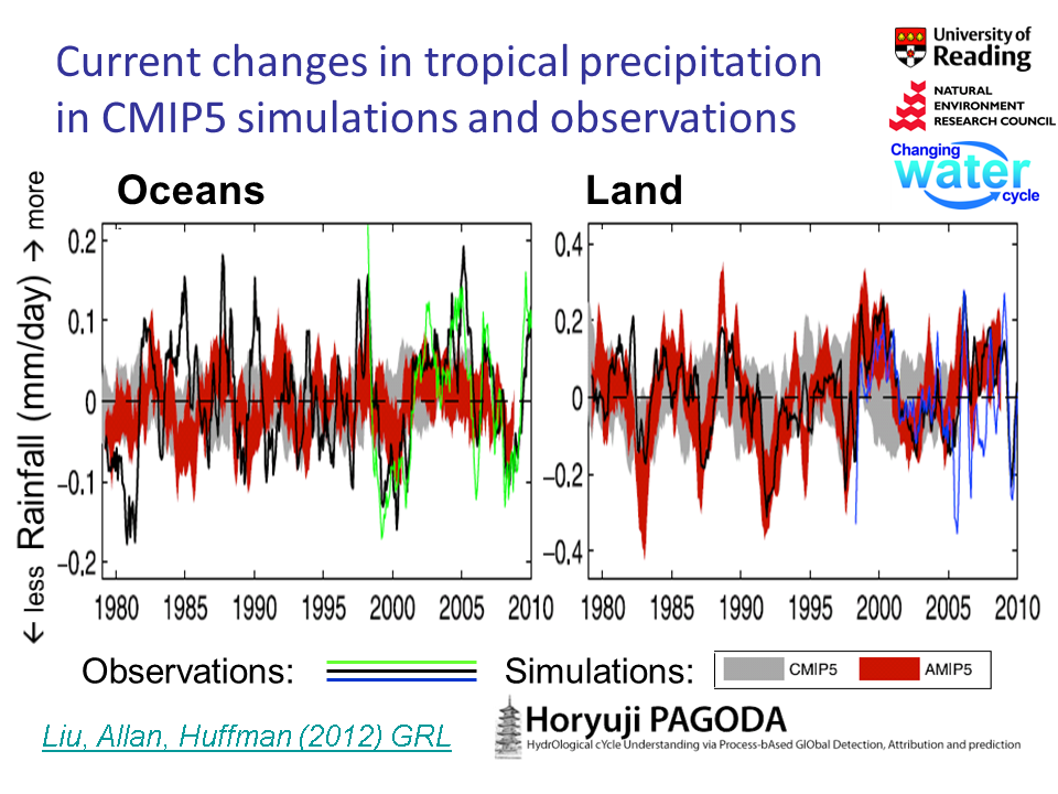
5) The AMIP simulations accurately capture the observed changes in rainfall over tropical land regions: there is up to 10% more rainfall than usual in La Niña years and up to 10% less rainfall in El Niño years. This is despite the AMIP simulations predicting their own land surface temperatures (only the ocean temperatures are provided as input). This suggests that the simulations are realistically capturing the processes determining changes in rainfall over land.
6) A discrepancy exists between the satellite observations and the simulations over the oceans: before about 1996 there is almost no agreement in the year-to-year fluctuations between the observations and simulations over the tropical oceans. After 1996 there is much better agreement but the observations show larger variation.
We discuss in the paper some possible reasons for this. One is that observing rainfall over the oceans is a challenge and there may be some inadequacies in the observations (although it is not clear why things improve after 1995). Another explanation could be that there has been a change in the nature of the natural ENSO cycle which, combined with the large simulation biases in the west Pacific and Indian ocean, may conspire to generate alternate periods of good and poor agreement.
The work is part of a larger project (PAGODA) looking at global changes in the water cycle which itself is part of a Natural Environment Research Council (NERC) program to study the Changing Water Cycle. The work also contributed to the NERC National Centre for Atmospheric Sciences (NCAS) and National Centre for Earth Observations (NCEO). The plan for further work is to look into and understand these discrepancies in more detail. Combining the observations and simulations is an effective way of improving understanding of our climate system in addition to assessing the fidelity of the observing systems and simulations, crucial for predicting future changes in the global water cycle.
Richard P. Allan Location: Department of Meteorology (2U15)
