Maidenhead (Berkshire, UK): Old weather news
A very poor late August Bank Holiday MondayWith low cloud and light rain and drizzle for much of the day, a northerly wind - and with no sunshine - the temperature in Maidenhead on Bank Holiday Monday could only rise to 15.6C. This is about 5 degC below average for the last day of August.
In local records going back to 1965 (when the August Bank Holiday was moved to the end of August) this was easily the coldest August Bank Holiday Monday on record.
In fact, this last weekend (in 2015) was generally a cloudy one. Over the three-day weekend only four hours of sunshine was recorded - more typical of a long weekend in winter than summer.
Overall. August was slightly cooler than normal, but much wetter and duller than normal. The summer will be remembered as one when any hot weather in Maidenhead tended to be short-lived. There were a few very wet days, but little thunder.
2015 - a slow start to summer 2015 has seen a slow start to summer-like weather.
By the end of April things had looked promising as the temperature in Maidenhead climbed to 25.8C on the 15th. Indeed, April was a warm and sunny month overall (1 degC above average), with more evaporation than usual. The warmth was largely due to the daytime temperatures; little cloud led to some cold nights but also helped to make it the sunniest April since 2010. Rainfall amounted to less than half the monthly average, leading to a dry ground surface for much of the last three weeks.
But May gave us a cool month in Maidenhead - the air temperature climbed no higher that 21.9C in the town. May was duller than April although the mean temperature was only slightly below average, while both sunshine and rainfall totals were close to normal for May. However, the maximum temperature of 21.9C was the lowest such value for May since 1986 - so maybe rightly the impression of 'no hot days in May this year' was a correct one.
The first half of June brought largely dry conditions, with the temperature reaching 24C on the 4th and 5th; then, after a cooler interlude, came 25.1C on the 12th and 24.2C on the 13th - before some dull, drizzly weather on the 13th and during the morning of the 14th.
The weather of 2014 - some local highlights: Warm and wet, with no snow
2014 was a very mild and very wet year. In local records going back to 1953 only 2006 was (marginally) warmer. Not until late December did the daytime temperature fail to reach 5C - the maximum temperature on the coldest day of 2014 was the highest annual value for ten years. The year was sunnier than normal and it was the wettest year since 2000 when 893.6 mm fell. 1958 was also wetter locally, while 1903 was wetter than 2014 by about 100 mm. Local daily snowfall records go back to 1936 and 2014 was the first year since then in which no sleet or snow was observed to fall in Maidenhead. Thunderstorms were more frequent, especially in the summer months, than in recent years although there were more thunder days in 2006.
More details can be found here with monthly notes here.
July 2014 - some hot weather
The last seven months have all been warmer than normal in Maidenhead - and July seems set to continue the trend.
Prior to the start of the July the highest temperature reached in the town was 27.2 C on 13th June. This reading was equalled on 12th July and passed on 17th July when 29.4 C was recorded. On Friday 18th it was only slightly cooler with a maximum temperature of 29.3 C and by Saturday morning the temperature had only fallen to a minimum of 18.7 C.
In addition, during the early hours of Friday 18th there was a heavy thunderstom in Maidenhead - 16.1 mm of rain fell and the lightning was very frequent at times, lighting up a lot of the sky. Judging by the loudness of the thunder, there were also one or two lightning strikes quite close to SW Maidehead.
During Saturday 19th the temperature rose to 28.1 C with no rainfall at all in Maidenhead after 10 a.m. Another warm night followed with the minimum temperature during the morning of the 20th falling only to 16.7 C, while on Sunday the thermometer climbed to 26.8 C in the afternoon.
Maximum temperatures remained high and nights were warm during the period 21st-24th. On these days the maximum temperatures recorded in Maidenhead got progressively higher with each successive day - 21st 27.2 C, 22nd 28.3 C, 23rd 29.1C and 24th 30.3 C.
The 24th was the warmest day of 2014 so far in Maidenhead while July so far has been slightly more than 1 degC warmer than average. The coming weekend should see a continuation of the warm/hot weather in Maidenhead - with slightly cooler conditions (but still warmer than average) for the remainder of the month.
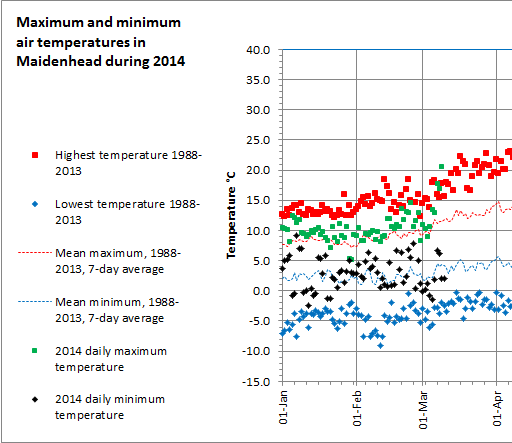
March 2014 - some warm days
The figure below shows the daily maximum (green) and minimum (black) temperatures in Maidenhead during 2014 - compared to the highest (red symbol) and lowest (blue symbol) and the daily averages (red dots, blue dots) in the preceding 26 years. Maximum temperatures on the 7th and 8th March were close to the highest on record for early March. On Sunday 9th 20.6C was recorded - probably the highest temperature this early in the year in Maidenhead since 1948. As the wind turned to a more easterly direction on the 10th the daytime temperature dropped noticeably.
The wettest winter since before 1859 in Maidenhead
February was, by the 7th, a wetter-than-average month. 25.6 mm of rain fell in the 24 hours to 7 a.m. on the 7th - this made Thursday 6th the second wettest February day locally in 35 years.
The total rainfall for February totalled 109.2 mm, compared to the average rainfall for the whole of February of just 43.7 mm. This makes it the wettest February since 1951 when 117.6 mm fell.
For the winter as whole (December, January and February), Maidenhead would normally expect to receive 169 mm of rain. For the winter of 2013/14 the rainfall total was 374.5 mm, making it the wettest winter in local records that go back to 1859. It is also worth noting that almost all of this rain has fallen since 13th December and the rainfall this winter is equivalent to 57% of the normal annual rainfall total in Maidenhead.
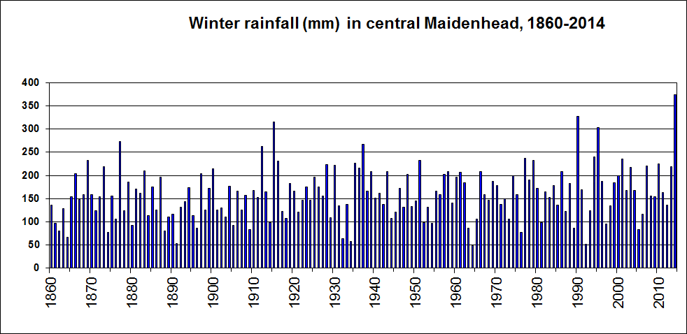
Only three other winters since 1859 have seen in excess of 300 mm falling - namely
- 1994/95 - 304 mm fell in Boyn Hill.
- 1989/90 - 327 mm was the total for the town,
- 1914/15 - 315 mm was the town's rainfall.
So what might come after this winter?
While historical weather events are not necessarily a guide to the future it is interesting to note what has happened after the wettest winters in the Maidenhead record prior to 2014.
- Each of the three winters listed above were followed by a dry or very dry spring.
- The spring of 1915 had two notable droughts when about 10 mm of rain fell in almost ten weeks. May was a little wet but then June was dry and July turned wet.
- In the spring of 1990 just 41.9 mm of rain fell locally making it the second driest spring on record in Maidenhead since 1859. The summer of 1990 was hot and sunny and after February it was a very dry until December.
- August 1995 was hot and dry and the summer was generally a warm one. The period April to August was remarkably dry with just 1 mm of rain and almost 270 hours of sunshine in August.
News reports are saying that the current local flooding along parts of the Thames Valley is the worst since early 1947. That year the winter precipitation amounts had been very close to normal - but all three months were cold with February having an average temperature that was some 6 degC below average in east Berkshire:
Not surprisingly then, weather records from the University of Reading show that snow fell on 21 days in February and March. With the ground frozen and snow covered, when the fourth spell of heavy rain in nine days fell on the 12th there was nowhere for melting snow and runoff to go except downhill and into the rivers.
But even in 1947 all the summer months from May to September were warmer than average with just 5 mm of rain in August. and ten days saw the temperature reach 30 C at the University during the summer.
Maybe this is just nature's way of saying that nothing lasts forever? But note also that there have of course, given the natural variability of the weather, been other very wet (but not quite as wet) winters after which the spring and summer months have not been so benign (for example
- the summer of 1877 when late May frosts in Berkshire created havoc with budding potato plants and only June was dry, and
- the spring/summer of 1912 when (after an almost totally dry April) the summer was one of the wettest for 50 years).
Fingers crossed then!
The wettest January since before 1859 in Maidenhead
Following a fall of 102.3 mm of rain in Maidenhead in December 2013, January has now given us a total fall of 163.0 mm, making it the wettest January on record in Maidenhead and the wettest of any month since November 2002. The normal January fall for the town is just 61 mm.
In local rainfall records going back to 1859 for the town, the previous wettest January month was that of 1988 (when the average rainfall for the local area was 131 mm - with 133 mm falling at the Water Works).
A lack of winter snowfall by 31st January - is this unusual?
As of the end of January no snow or sleet has been observed to fall at Boyn Hill. With daylength now slowly increasing, and with the expected temperatures (our climatology) getting slowly warmer, will we get any snow at all? We need to go back to the winter of 1991/2 to find the previous winter when no snow at all had fallen by the end of January. However, in February that year we had snowfall on the 18th with a slight cover (less than 50 per cent) on the ground at 9 am. that day - and we even had a slight snowfall on 15th April.
In the winter of 1989/90 the first winter snow fell on 3rd February and 25th March. Both falls were slight, however.
Going further back to 1973/74 (using observations from Hurley) the first snow did not fall until February (with falls on two days) while there were two more days with snowfall in March. In both these months snow lay on the ground (with more than half the ground covered by snow) on one morning. On 10th March the snow was about 5 cm deep in places - deep enough for sledging!
So maybe those dusty sledges may get used yet this winter.
2014 starts where 2013 left off - with wet weather
Conditions during the first few days of 2014 have been rather wet and, at times, stormy, in Maidenhead. During the first fours days of January a total of 45.1 mm of rain has fallen in the town - almost three-quarters of what we would expect to fall in an entire January month. It is not surprising, therefore, that some local fields are flooded, especially as an additional 98.5 mm of rain fell in the last 17 days of December 2013. Combining these two rainfall totals means that over one fifth of our normal annual rainfall has fallen in just three weeks.
Some snippets from 2013
- The coolest year since 2010
- Highest maximum temperature: 32.9C, the warmest day since July 2006
- Highest minimum temperature: 19.2C; July gave us the joint warmest night since July 2006
- Lowest minimum temperature: -4.8C; An absence of really cold nights during 2013, -5C was not reached
- No. of days reaching 25C: 35; The greatest number of hot days since 2006
- No. of nights remaining at 15C or more: 27; The greatest number of warm nights since 2006
- No. of days with over 12 hours of sunshine: 25; The greatest number of sunny days since 2007
- No. of days with snow or sleet falling: 25; The greatest number of snowfall days since 2010
- No. of ground frosts: 116; The greatest number of ground frosts since 2003
July 2013 - a long hot spell breaks a run of six consecutive cold months
Following the period January- June 2013, during which the mean temperature each month was below average, July brought a welcome spell of hot weather to the UK, including Maidenhead.
A temperature of 31.4 C was reached in Maidenhead on Saturday 13 July - the highest temperature since 31.4 C on 26 July 2006. On 27 July 2006 the temperature had been as high as 32.7 C following 35.1 C on 19 July 2006.
Sunday this year followed a sequence of warm/hot days during which the maximum temperatures in the town had been as follows:
4th 24.1 C
5th 26.0 C
6th 27.4 C
7th 29.5 C
8th 27.2 C
9th 27.1 C
10th 24.9 C
11th 23.0 C
12th 25.5 C
13th 31.4 C
With maximum daytime temperatures expected to remain around 28 C for much of the forthcoming week - and possibly into next weekend - this current spell of hot weather is on target to be the most memorable hot spell since July 2006. That month the 11th-30th was unusually hot with 30 C being reached on 8 days - following a warm June.
In 2010 the 13 days from 21 June to 3 July were almost as warm - with the temperature climbing to a high of 29.6 C on 27 June.
March 2013 - the coldest by day for over 110 years
With an average temperature of 4.1C (3.5 degC colder than average) March 2013 was the coldest March in Maidenhead since 1962. Only three days had maximum temperatures above average and during the 23rd to 25th maximum temperatures were lower than what would normally be expected overnight during late March.
The persistence of winds from between the north and east was remarkable - at 0900 GMT the wind blew from these directions on 24 days. Given that Scandinavia was very cold in late February and throughout March it was not suprising, therefore, that March was cold in Maidenhead.
Sunshine duration was much less than average in March with 66 hours measured compared to the climatological average of 111 hours. These cloudy conditions meant that nights were milder than might have otherwise been expected in such 'easterly conditions' (being 2.5 degC colder than average) while days were colder (at 4.5 degC colder than average).
In fact, the cold conditions by day were remarkably cold relative to the average for any month - the anomaly of -4.5 degC made March daytime temperatures the lowest locally for over 110 years. Even in 1962 the March daytime temperatures were about 1 degC higher than in 2013.
March 2013 was only marginally warmer (by less than 0.1 degC) than February 2013, and was colder than January 2013. More information can be found here.
Cold days in March 2013 (updated 25 March)
Correctly, the overall perception of March 2013 has been one of mainly unusually cold conditions. Here in Maidenhead three days have stood out in this regard, namely
- 11 March - maximum temperature 1.8C
- 23 March - maximum temperature 1.5C
- 24 March - maximum temperature 1.3C
Each of these readings are remarkably low for March in Maidenhead. On average, the coldest day in March records a maximum temperature of 6.0C. Since 1953 the only colder March days in Maidenhead than those that have occured in 2013 were in 1986 (maximum temperature 0.6C on the 1st with the temperature at Hurley failing to rise above freezing), in 1965 (1.3C on the 4th) and 1971 (1.6C on the 6th).
The readings of 1.5C on the 23rd and 1.3C on the 24th in 2013 are the more remarkable in that during 40 years of temperature observations at Hurley (a slightly colder site than Maidenhead), the coldest March day during 21st-31st March was a relatively 'balmy' 2.8C on 24 March 1969.
Deep snowfall, January 2013
The snow depth peaked at about 15 cm on Friday 18 January 2012 but by 0900 GMT on Saturday had fallen slightly to 12 cm, with a depth of 9 cm being recorded on Sunday morning, just before the advent of another spell of snowfall. The initial fall of snow on Friday was brought to us from the west, while on Sunday we caught the western edge of an area of snow that pushed NE'wards across SE England from the near continent.
The Saturday depth of 12 cm was the deepest morning depth since the 13 cm that was measured on 21 December 2010. In the past 23 years at Boyn Hill there have been three spells with deeper snow - all occurring relatively recently - namely 18-27 December 2009 (16 cm on the 18th), 6-16 January 2010 (16 cm on the 7th) and the 18-28 December 2010 (15 cm on the 19th and 20th).
The fall this year (January 2013) was preceded by an 'ice day' on the 16th (a day when the maximum temperature remained below 0C) but conditions have not been particularly cold so far this month at night, due to rather cloudy skies. The minimum temperature as of the morning of the 20th had been only -3.6C on the 16th.
The year 2012 - from drought to rains
Temperature and sunshine averaged close to normal values, but there was a large range of temperature with an unusually cold day in December. The year turned from one of drought to flood and was the wettest overall since 2000, although only 84mm fell in the first three months. Five months recorded in excess of 100mm of rain; this has never happened before in the local record back to 1859; there were 4 instances in 1946.
August 2012 - a touch of summer and a hint of autumn [Corrected version]
Following a rather cool and wet start to summer, August produced conditions that were more akin to an English summer in Maidenhead. Temperatures averaged out at 0.6 degC above average (the warmest August since 2009) with temperatures reaching 30 C on the 19th (the highest August temperature since 2005 although not as high as the 30.7 C recorded on 25 July 2012).
With one day still to go, rainfall during August was slighty more than half what we would expect in the month at 27.8 mm. This made it the driest August since 2003.
But autumn made an early appearance on the 31st when, under clear skies and a light wind, the temperature fell to 4.7 C - the lowest temperature in August in central Maidenhead since 1979 and the secomd lowest for over 60 years, although in 1979 2.6 C was recorded on the 28th at Hurley.
As for the summer (June-August) - this was the warmer than in 2011 but cooler than in 2010, and summer 2012 was cooler than average due to a cool June-July period. Rainfall amounted to 283 mm in total, making it the second wettest summer in Maidenhead in the past 60 years after 2007, when 295.9 mm of rain fell. In an aveerage summer we would expect only 146 mm of rain to fall.
June 2012 - a very wet and rather dull start to summer in Maidenhead
A total of 128.1 mm of rain (corresponding to 2.7 times the average) fell in Maidenhead during June, making it the wettest June in the town since 1903 - when 157 mm of rain was measured. In fact, since 1859 only the Junes of 1903 (when there was some flooding along the Thames locally, and three successive days recorded over an inch of rain) and 1879 (which was a bad, wet summer for farmers) have been wetter. Usually, one or two heavy thunderstorms are the reason for having a wet June. In 2012, however, no thunder was heard at Maidenhead while rain fell on 21 days with the longest rainless spell lasting just two days. This year much of the rain was brought by depressions and frontal systems - pushed towards southern Britain by the jet stream.
June was slightly wetter than April - and the three-month period April to June 2012 brought 268.8 mm, the wettest such late spring/early summer in the past 150 years apart from 1903 (when 288 mm fell) and 1879 (when 295 mm fell). Not surprisingly then, the perception of the start of this summer has justifiably been a poor one - with just a week of hot weather in late May seeming to break the wet spell. This June, Maidenhead escaped the very heavy and damaging falls that affected some other parts of Britain.
The same cloud that brought the rain has also been keeping the sunshine away. We had just 127.8 hours of sunshine in June - making the month duller than each of March, April and May this year. The June total was just two-thirds of the average June sunshine duration - making it the dullest June since 1991 - with eight days failing to register one hour of sunshine. Even when the sun did come out it failed to shine for long - the sunniest day saw just 11.5 h of sunshine, a statistic more typical of April.
A lack of sunshine meant a cool month; after a warm start there followed a fortnight when daytime temperatures did not reach the expected levels for early June. June was the coldest since 2002 and only one day passed 25 C. The month was 0.8 degC colder than average.
Sudden rise in temperatures, late May 2012
Following on from a cool April, temperatures in early May had been somewhat below average. On the 20th the maximum temperature was just 12.0 C, some 6 degC below average. By the afternoon of the 22nd, however, 26.1C had been reached, followed by 28.2 C on the 23rd and 27.8 C on the 24th.
However, these readings were still a little way below the May record temperature; 29.1 C recorded in May 2010. In 2005 30.2 C was reached in May with 30 C in May 1953. Even the warm night of 23rd-24th this year (the temperature did not drop below 16.4 C) was exceeded in 1998 when the 14th dawned after a night when the temperature did not fall below 17.3C. Overnight into the 25th the temperature did not fall below 15.8 C.
Record high air pressure for May
The MSL pressure reading on my barograph at 0900 GMT on 12 May was 1038.0mb. Records from nearby Heathrow Airport indicate that this is a new record high pressure for the area for May - since at least 1949. (Source: Stephen Burt.) In SW Ireland both Sherkin Island and Valentia reported 1043mb during late morning - an all-time record high May pressure for anywhere in the British Isles.
A cool and wet April 2012
Some statistics for April rainfall - the wettest Aprils since 1925 have been:- 2012 114 mm
- 2000 120.7 mm
- 1998 106.0 mm
- 1983 100.0 mm
April 2012 was colder than March 2012 - is this turnaround in temperatures a rare event? In fact it is not uncommon - in recent years both months have had a similar mean temperature in the same year on several occasions, while since 1953 the following have been colder in April than in March in Maidenhead:
- 2012 0.6 degC colder
- 1990 0.1 degC colder
- 1989 0.7 degC colder
- 1981 0.2 degC colder
- 1957 0.2 degC colder
A spring-like March 2012, although quite foggy at times
March 2012 was a remarkably sunny month with 172h of sunshine recorded in Maidenhead - well above the average for the month of 111h. Although it was only the sunniest March since 2009, since 1953 there been only four sunnier March months. And the ten-day spell of sunny weather during the 21st to 30th brought over 96h of sunshine - an amount that is more typical of mid-summer than early spring.The ground was starting to crack by the end of the month - a result of warm sunshine but also due to a lack of rain during the month. The total for the month of 19.6mm (less than half the average) was more than fell in March 2011 - but only 1mm fell during the final 24 days of the month.
Daytime temperatures averages 3.4degC above average with a very warm 22.7C recorded on the 28th. But night-time temperatures were very close to average - the same clear skies that allowed warm conditions during the day results in some sharp cooling of the air overnight although overall there was less frost than normal. It was a warm as March 1995 but much cooler than March 1957.
Mist, fog and poor visibility were a feature of many of the mornings, especially during the first half of the month. In central Maidenhead there were five mornings with fog at 9am - about the number that would normally occur in ten March months. The March months of 1997 and 1992 also had five foggy mornings - while in 1982 there were six foggy starts.
Mild weather on 23 February 2012 in Maidenhead
The maximum temperature of 16.6C recorded on this day was the highest in February in the town since 18.4C was recorded on 13 February 1998. On 23 February 1990 a temperature of 18.5C was recorded - these two days being the two warmest in February since before 1989.Considering other February days, the 16.6C this year (2012) made the 23rd the fourth warmest February day in the town since before 1989; it was about 9 degC higher than would be expected for this date.
It is worth noting that at nearby Hurley during the period 1953 to 1991 these temperatures were never exceeded in February.
February snowfalls
Following a fall of 15.7mm of water-equivalent precipitation during the afternoon of the 4th into the morning of the 5th February 2012, a level snow depth of 10cm was measured in Maidenhead at 0900GMT on the 5th. This was the greatest February snow depth only since 2 February 2009 when 10cm also lay. Other recent February depths in Maidenhead have included 9cm on 8 Febnruary 2007 and also on 8 February 1991.During the mid-1980s there were similar snow depths reported from nearby Hurley on 6 February 1986 (when 9cm lay, with snow continuing to lie until the 15th) and on 9 February 1985 (a depth of 10cm - then the snow also continued to lie until the 15th).
In 2012, the snow was slightly wet as the air temperature during the period of snowfall and on the 5th was slightly above 0C - making the snow ideal for snowballs and snowmen!
- In Maidenhead a further snowefall overnight 9th/10th led to 8cm of lying snow for a while.
The cold snap of early February 2012 in Maidenhead
The minimum temperature recorded on the 4th was -7.5C, the lowest temperature since December 2010 when -9.9C was measured, and the lowest temperature for February since 7 February 1991 when -7.5C was also noted. In fact this was the equal coldest February night since before February 1989 in Maidenhead.There have been colder February nights, however. In 1986 the 10th and 11th of the month were cold with the (now-closed) climatological station at Hurley reporting -11.6C and -10.3C respectively while in 1956 -10.6C was measured on the 2nd.
Nearby, Reading University reported -11.6C in February 1986, -9.4C in February 1956, while in February 1947 the University recorded -12.2C in what was part of a very cold winter season.
- As a result of clear skies and lying snow, temperatures fell slightly lower in Maidenhead early on the 11th (-9.0C) and 12th (-7.6C), although by dawn on the 12th things had warmed up considerably as cloud advanced overhead.
Some snippets about the weather of 2011 in Maidenhead
- Mean maximua temperature 16.3C, The equal warmest year during daytime on record with 2003
- Mean temperature 12.0C, The second warmest year on record, 0.2C cooler than in 2006
- Highest maximum temperature 29.6C, 30C was not reached for the first year since 2008
- Lowest minimum temperature, -3.7C (normal -7.0C), No particularly cold nights this year
- Total sunshine 1585.3h, Slightly sunnier than average - May, then April, were the sunniest months
- Total rainfall 601.0mm, Rainfall lower than average but not as dry as in 2010
- Number of days with
- Snow or sleet falling 4 (normal 12.2), The fewest snow days since 2002
- Thunder heard 4 (normal 13.0), The lowest number of thunder days since before 1936
- Fog at 0900GMT 3 (normal 9.4), These foggy mornings were all in November
- Air frost 25 (normal 40.0), The fewest air frosts since 2002
Hot spell, September-October 2011
High daytime temperatures during this spell included26.6C (28th September), 28.3C (29th), 28.5C (30th), 28.6C(1st), 28.2C(2nd), 26.0C(3rd). My maximum temperature forecasts (made on the 1st) for forthcoming days (see below):
28C (1st), 27C (2nd) and 25C (3rd).
In records from 1988 the highest temperatures during the final week of September have been as follows:
23.8C on 24 September 2006
23.0C on 26 September 1992
22.8C on 25 September 1989 In the same period the highest temperatures during the first week of October have been:
25.2C on 1 October 1997
21.5C on 6 October 1997 Local Hurley records (with adjustments made for site differences) show that since 1953 high temperatures in October in Maidenhead have been
26.4C was the temperature on 1 October 1985,
25.6C on 9 October 1969 (part of a warm spell from the 8th to 10th),
26.7C on 3 October 1959 In earlier years local maximum temperatures (77F/25C or higher) have been as follows in October:
1869 - 25.0C at Stratfield Turgiss;
1908 - 25.6C at Wokingham,
1921 - 28.3C at University College (Reading) and Wokingham, and 27.8C at Shinfield
Damaging lightning
28 June 2011 brought damaging lightning strikes to parts of Maidenhead - from storms that signalled the end of a short heatwave in which temperatures reached 29.6C. This equalled the highest temperature recorded in June 2010 and was the highest temperature of 2011 to date. Only 3mm of rain fell during the afternoon of the 28th - but it brought the total fall for the month up to 87.2mm (some 35mm above the June average - making it the wettest June since 2007 in the town).
A warm Easter/April 2011
As of 27th April the mean temperature for April 2011 is running close to 5C above average - while the 26.8C recorded on Saturday 23rd is the highest temperature on record for April in Maidenhead since before 1952. April 1949 had a similarly warm day in East Berkshire.
December 2010
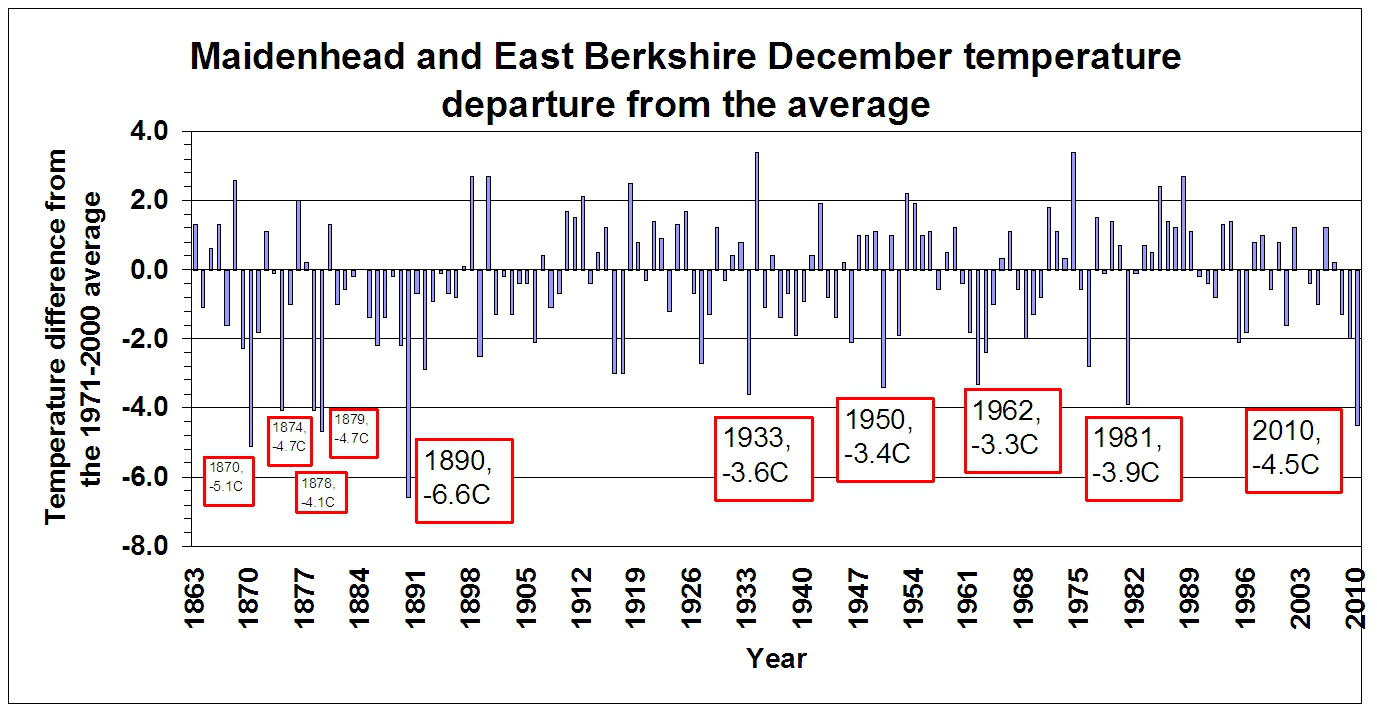
The minimum air temperature of -9.9C on Monday 20 December 2010 was the joint lowest since -9.9C was recorded in January 1987 and the lowest since January 1982 when -14.9C was recorded at Hurley (in Maidenhead it probably did not drop below -14C). The crunchy nature of the 15cm of lying snow on the morning on the 20th in 2010 reflects the fact that at the snow surface the temperature dropped as low as -14.4C - the lowest since -15.2C was measured in the town in January 1987. December 2010 was the coldest December since 1890 in the town. That year temperatures were about 2.1C COLDER than in December 2010.See here for a chart of December temperatures.
November snowfalls
November snows are not uncommon in Maidenhead. The snow on Saturday 27th in 2010 was the first in November since only 2008 (we had two snow days in October that year) and on average we get 4 November snow days every ten years. The first day with snowfall during autumn/winter occurs on average on 16 December (during the past 22 years) and in two-thirds of those years occurred between 19 November and 12 January. Snow lying (and covering half the ground at 0900GMT) in November is rare - it has not happened at all in Boyn Hill since observations began in 1988 and at Hurley between 1953 and 1991 happened only on single days in 1969 and 1971. *****The minimum air temperature of -5.8C on 28 November 2010 was the lowest for November since 1989 in Maidenhead, when -6.3C occurred.
The minimum air temperature of -0.1C on 12 May 2010 was the lowest for May since 1997 in Maidenhead, when -0.9C was measured.
Maidenhead: The 2009-2010 cold spell - daily temperatures
See my charts updated 17 Jan 2010.The 24 days 16 Dec 2009 - 8 Jan 2010 had an average temperature of +0.3C.
Since 1988 there have only been two 24-day spells of a similar length - 24 days commencing 16 Jan 1991 (-0.1C average) and 24 days commencing 22 Dec 1996 (+0.1C average). In neither of these was the snowfall anywhere as great as in 2009-2010.
Prior to 1988, records from nearby Hurley reveal that slightly colder spells of this duration occurred in February 1986, January 1985, December 1981-January 1982 and in the winter of 1962-3. This last spell occurred for about 10 weeks - but there was very little snow lying locally - see the winter 62-63 chart.
A recap of the greatest snow depths of the past 21 years at 0900GMT
- 1991 8 Feb 9cm
- 2007 8 Feb 9cm
- 2009 2 Feb 10cm
- 2009 18 Dec 16cm; 19 Dec 9cm
- 2009 22 Dec 10cm
- 2010 6 Jan 14cm; 6 Jan 17cm (at 1600GMT); 7 Jan 16cm; 8-9 Jan 14cm; 10 Jan 13cm; 11 Jan 9cm; 12 Jan 8cm; 13 Jan 12cm; 14 Jan 9cm
One measure of the amount of snow is to calculate the accumulated snow depth on the ground over a period of time. This is done by adding up the snow depth every day at 0900GMT to arrive at a total.
Here are the snowiest winters since 1988-1989 using this method:
- 1990-1991 - 45 cmdays
- 1995-1996 - 18 cmdays
- 2000-2001 - 19 cmdays
- 2006-2007 - 13 cmdays
- 2008-2009 - 26 cmdays
- 2009-2010 - 176 cmdays (to 0900GMT on 17 Jan)
Recent White Christmases in Maidenhead (since 1988)
Definition - at least one snowflake falling on the 25th.
- 1999 - sleet fell
- 1996 - snow fell
Other useful links
- My homepage/surface charts
- Local weather:
- Maidenhead's recent weather and climate
- Reading's climate, 1991-2020
- Current UK/Ireland weather information:
- Maps:
- Current temperature
- Current weather
- Plotted daily extremes
- Current weather
- Monthly summaries:
- The month so far - text
- Last month - text
- The month so far - charts
- Last month - text
 August 2016: Details
and order form for this new book about weather observing.
August 2016: Details
and order form for this new book about weather observing.
 Details
and order form for this limited edition publication.
Details
and order form for this limited edition publication.
Met Dept Home
- My publications
- Maidenhead weather
- Current, recent and historical weather in Reading, Berkshire
- East Berkshire temperatures
- Maidenhead (Berkshire) rainfall
- UK weather diary
- Reading weather 'on this day in ...'
- World weather news stories
- Met-Jobs mailing list
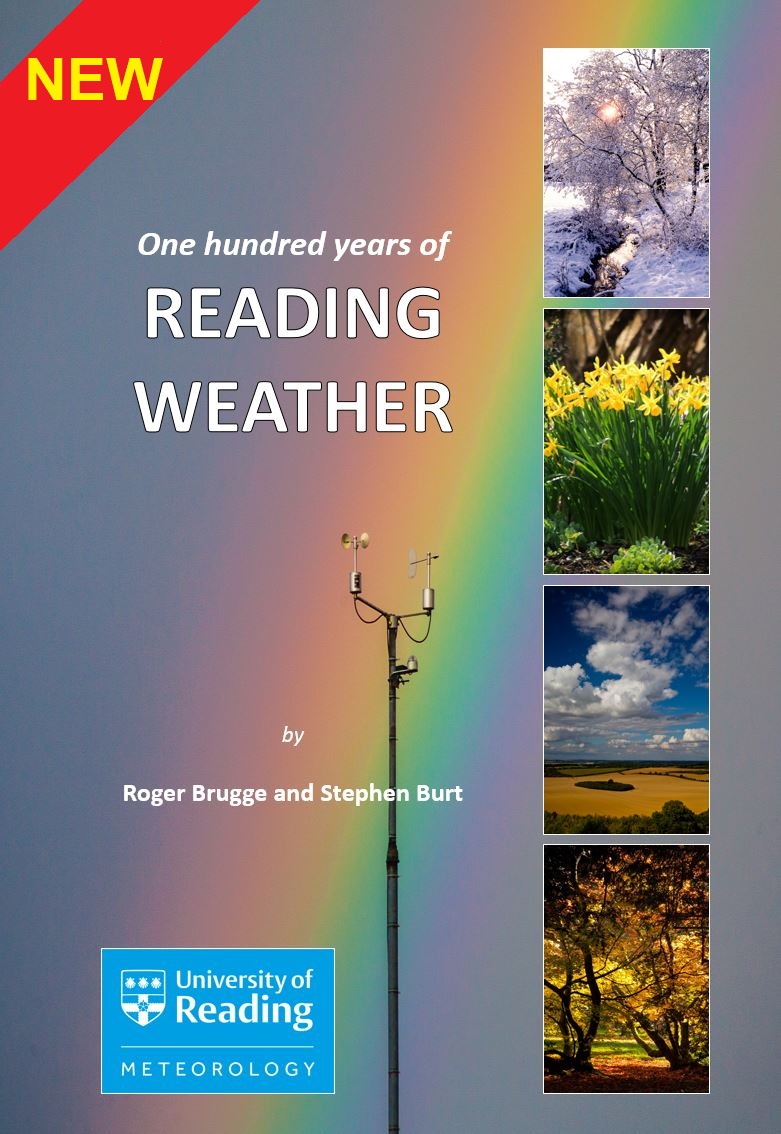 Read about and order this NEW book about the weather of Reading.
See also
Make your own weather observations? Then see the Climatological Observers Link
The Tornado and Storm Research Organisation
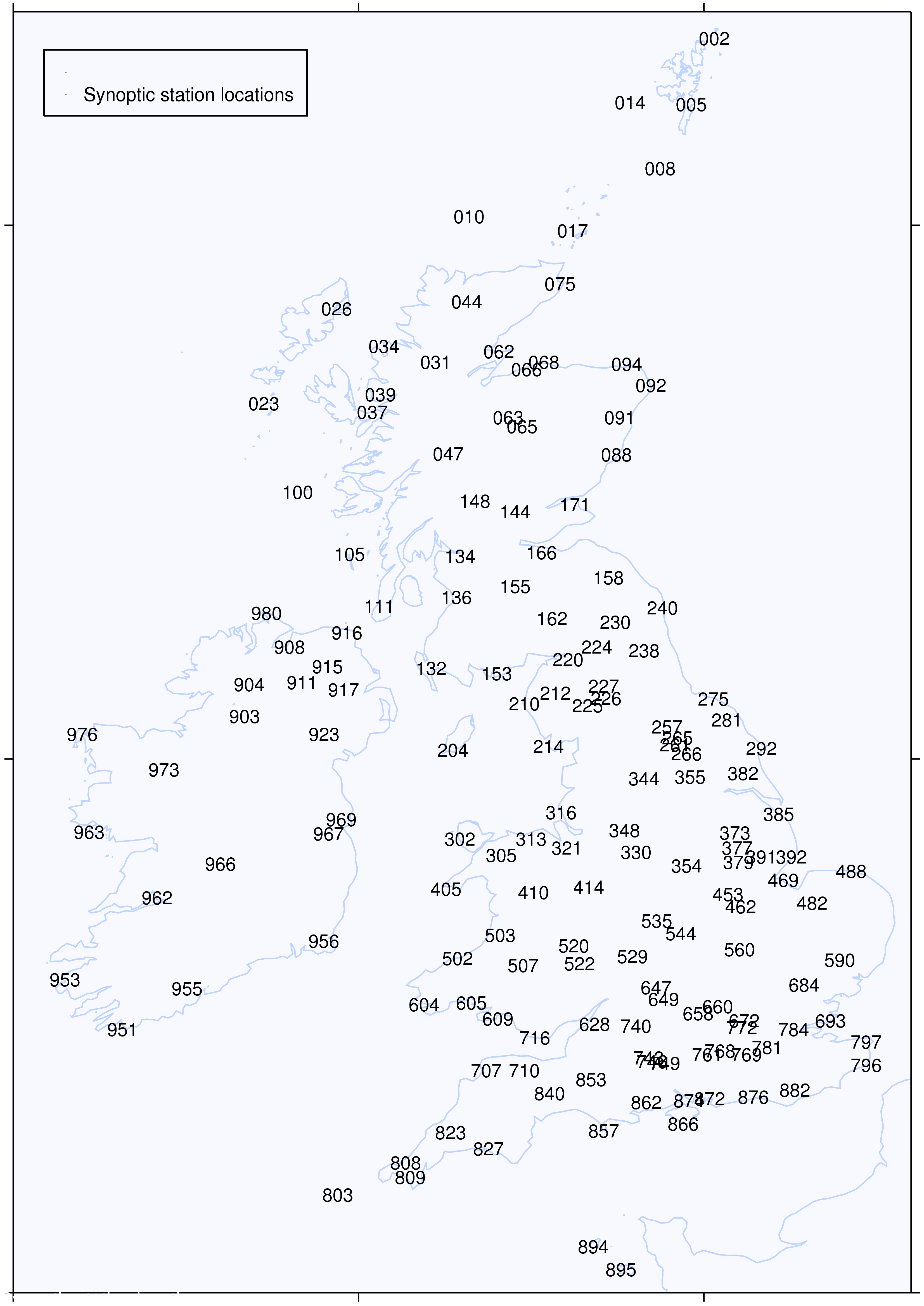
UK/Ireland synoptic station locations:
- Maidenhead weather