
December 2013:
December 2013 Christmas Eve Storm
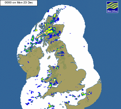
Strong winds and heavy, driving and continuous rain hit the UK during the pre-Christmas period causing power cuts and travel disruption. The Met Office radar (right) shows the complex series of fronts and troughs including squall lines of intense rainfall and high winds.
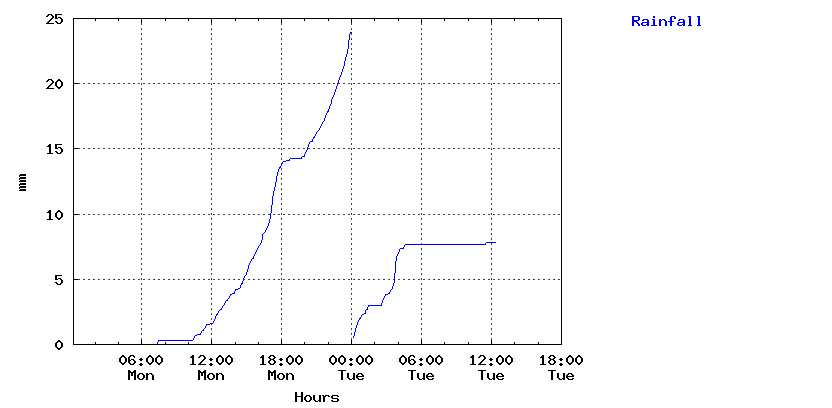
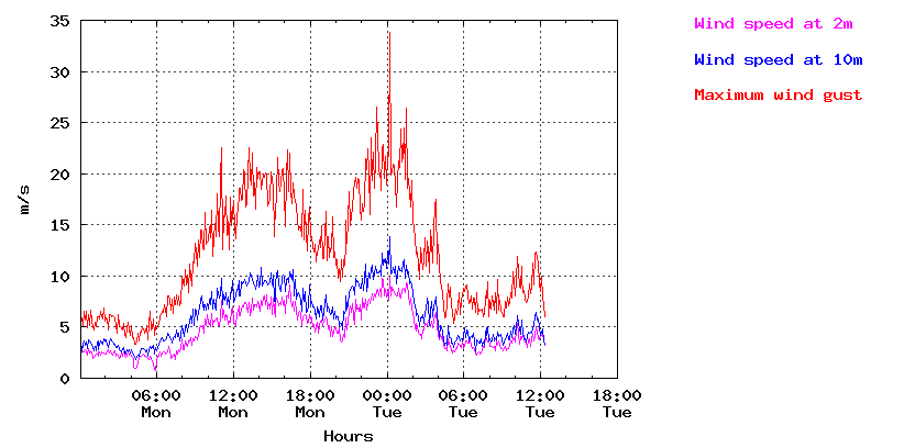
Nearly 40mm of rainfall was measured in 18 hours by the automatic rain-gauges at the University of Reading Meteorology field site with a peak wind gust of about 34 m/s (122 km/hour) just after midnight in the early hours of the 24th December, the second and strongest wave of high winds associated with the trailing cold front (see synoptic chart below).
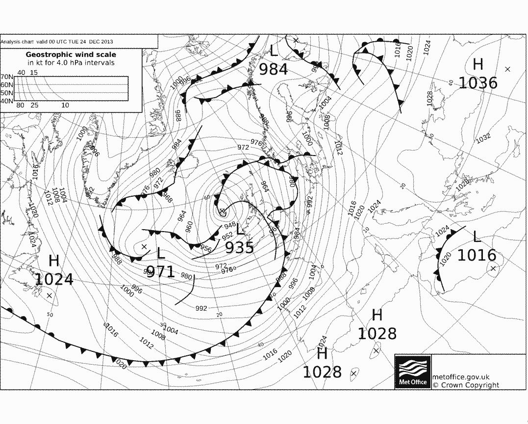
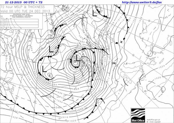
The low pressure area was around 935 mb just to the west of the Scottish Islands, close to a record for the UK (see Eddy Graham's Hebridean blog and a discussion by Christopher Burt on wunderground.com). However, some of the strongest winds battered southern coastal counties of England, associated with the tightly packed isobars ahead of the cold front. It is worth noting that the storm was very well predicted by the Met Office as can be seen from the 72 hour forecast synoptic chart made on the 21st December below.
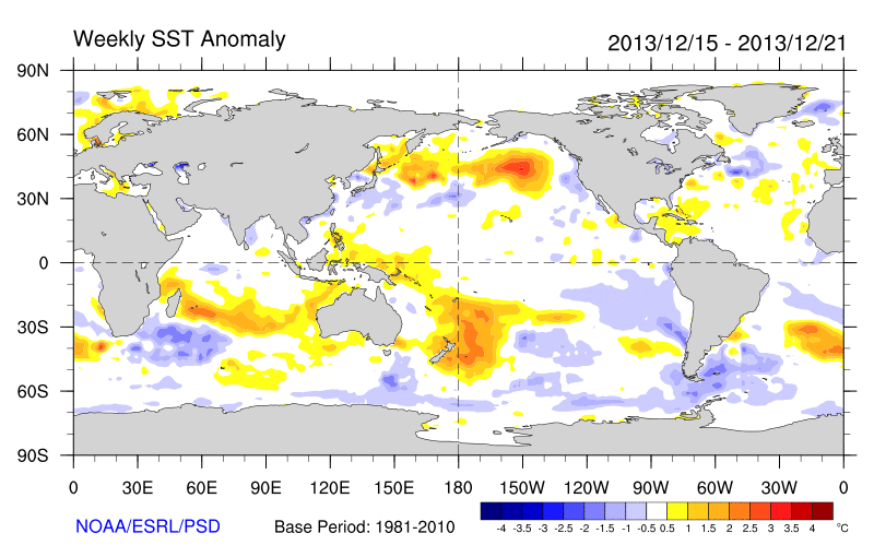
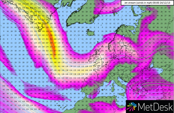
The storm developed and deepened rapidly as predicted by the Met Office forecast, aided by an extremely strong jet stream, possibly associated with the cold sea surface temperature anomaly in the north Atlantic off the coast of Newfoundland and associated strong gradient in temperature between warm sub tropical regions and cold sub-Arctic regions. The contrast between warm and cold was particularly evident over North America with temperatures at one point reaching 21oC in New York compared to -7oC in Montreal just 500km away (see discussion by Peter Gibbs on BBC Weather). The strength of the jet stream appeared unprecedented at midnight going into the 24th with winds exceeding 250 miles per hour according to Met Desk.
Another storm is predicted to hit the UK on Friday the 27th December but thankfully it looks less severe than the one described above [UPDATE: it was strong enought to blow down my fences!].
As a final thought, a recent comment in Nature Geosciences by Jon Robson and colleagues from the University of Reading may have implications for the North Atlantic jet stream and UK weather (see discussion on Ed Hawkins' Climate Lab Book blog). A slowing of the North Atlantic overturning ocean circulation, long predicted by climate model simulations into the future, may have begun according to a detailed analysis of observations and simulations.
This slow but immense ocean circulation transports vast amounts of heat northwards into the North Atlantic. The predicted slowing of this circulation in response to fresh water input from melting ice and increased precipitation and river flow associated with a warming climate, could plausibly cause an increase in the atmospheric temperatre difference between the warm sub tropics and the cold sub Arctic, with albeit far from certain implications for the strength and position of the jet stream and UK weather patterns. A continued slowdown in the Atlantic Meridional Overturning Circulation could also reduce the number of Atlantic Hurricanes and increase the risk of drought in north Africa.
Return to Latest News
Richard P. Allan Location: Department of Meteorology (2U15)
