| Flight | Brief Summary | Instrument notes |
| B422 15 Jan 2009 | Patchy multi-level altocumulus layers, coldest about -18C, some ice falling out. 2DC images show lots of thin (transparent in the middle) plates, large particles = stellars and dendrites (2DP), a few aggregates. Some images of 'double plates' (112030.64). First run 1110. Last run 1348. Numerous level runs, altitudes 11kft-19kft. RHI scans from CAMRa. Surface measurements. Vertically pointing radar/lidar/radiometer measurements. Detailed plots from vertical instruments | All radars and lidars OK. Low cloud, but broken enough for lidars to see supercooled clouds above |
| B423 20 Jan 2009 | Convective showers in Bristol channel. Only cirrus over Chilbolton, did a couple of runs through that (1230) and then went west. Temp -30 to -40, no supercooled. Vertically pointing radar/lidar/radiometer measurements. | 94GHz popped all rest OK. No low cloud. |
| B424 21 Jan 2009 | Warm front moving in from west: High and mid-level cloud then rain band. Strong jump in Z, ZDR sloping upward away from radar over ~60km = frontal surface? Later Embedded convection - puffs of high Z with high ZDR patches at top, 35GHz Doppler spectra show bimodal features indicating new crystal growth (small crystals) and then later riming (fast falling particles). Small patch of supercooled visible to ceilometer at 1500m, specular layers in Dopp. Lidar. EZ lidar sees through thick ice/rain at 1700 to layer of detectable backscatter - must surely be liquid, 5000m. First run 1535. Last run 2001. Various level runs, altitudes 2kft-11kft. 2DC images show dendrites and plates; aggregates; columns/needles? Evidence for Kelvin Helmoltz billows at ~1km in vertical wind shear. RHI scans from CAMRa. Surface measurements. Vertically pointing radar/lidar/radiometer measurements. Detailed plots of interesting features from CAMRa | All OK except 94. No low cloud so lidars see in before rain. Met Office sondes released at 1hr intervals to 1800. No CPI on plane, but did have 2D-S. |
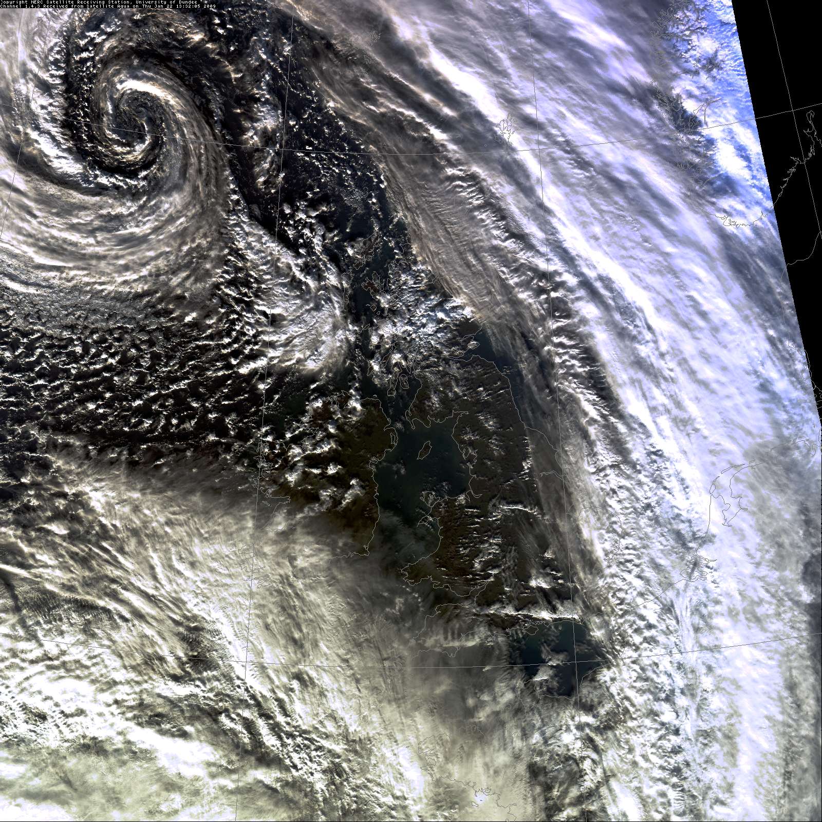
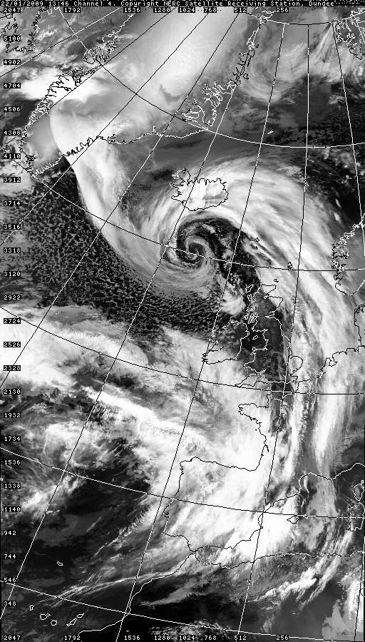
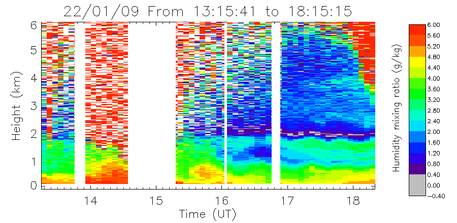
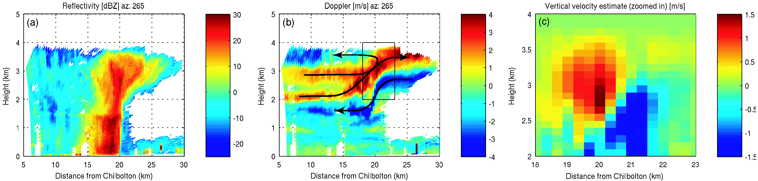
| B425 22 Jan 2009 | Line of weak showers lining up west of Chilbolton 1330. Aircraft sampled with series of level runs through cloud plus sawtooth run - supercooled liquid and ice. Clear air echo from capping inversion. Aircraft then moved off to sample warm front in Bristol channel, didn't return to Chilbolton (comms failure). High-res vis image, UK 13:30 IR pic RHI scans from CAMRa. Surface measurements. Vertically pointing radar/lidar/radiometer measurements. Water vapour profiles from raman lidar | All OK except 94. No low cloud so lidars saw in except during rain. |
| (27 Jan 2009) | Cancelled - clear skies at Chilbolton. | - |
| B426 28 Jan 2009 | Thinning remnants of stalled front. Focussed on relatively persistent mid-level layer cloud, top approx 5500m, 1.5-3km deep. Aircraft sampled this quite extensively at 1000ft intervals: first run 0940 last run 1343. Also did 1 run in thin liquid cloud at 2km altitude - barely supercooled, not much ice. Some enhanced spectral width in radar and jump in Z suggested s/c liquid. Fairly cold -22C ish. Aircraft reported supercooled liquid, + some plates. Was seeded from cirrus above (top 8km) at one stage, irregular crystals/aggregates, saw corresponding lowering of virga cloud base. 2DC shows irregular polycrystals/aggregates and plates in roughly equal mix. Sampling at base of virga noted some mixed phase conditions - maybe evaporative cooling from ice sublimation? RHI scans from CAMRa. Surface measurements. Vertically pointing radar/lidar/radiometer measurements. Detailed plots. | All OK except 94. Low cloud, lidars completely socked in. |
| (30 Jan 2009) | Front slowly being pushed back westwards by dry cold air from SE. Fantastic multi-level altocumulus layers, coldest about -25C, 3km ice virga falling out, specular reflection [lasted 34 hrs straight in the end] . Flight had to be abandoned just after take off because of landing gear problem. Stayed and did a number of CAMRa scans in various directions - ZDR data might be interesting [v. strong signatures, at cloud top esp later scans]. RHI scans from CAMRa. Surface measurements. Vertically pointing radar/lidar/radiometer measurements. | All OK except 94. No low cloud, lidars had an excellent view. |
| B430 18 Feb 2009 | High pressure over SW England, front from W stalling over Chilbolton. Thin supercooled mid-level cloud persisted over Chil for more than 24hrs, virga from this was seeding strato-cu beneath, producing very light drizzle at ground. 06 Larkhill shows big inversion at top of water sat layer approx 3500m -12C. 2DC shows plates galore, with large stellars and dendrites. RHIs indicated some more convective cloud at approx 20km range W Chilbolton on standard 255 radial, plume of high Z with high ZDR ice in thin layer at top and spilling round sides. Aircraft confirmed 'bumpy' in this region, central core of supercooled liquid (0.25g/m3) surrounded by falling ice. CPI saw big s/c droplets, large dendrites, plus many small irregulars (splinters?) and many needles, suggest Hallett Mossop likely. Convective feature was remarkably stationary, as was mid-level layer cloud (stripe approx 200km across, see IR pics) and both were sampled comprehensively in-situ with a series of straight and level runs, from just above cloud top, down through the cloud at 1kft intervals, and into the strato-cu to investigate the seeding effect. Example RHI scan across line of embedded convection, and updraught estimate Copy of the xchat communications (pdf). Operational rain radar plots, Zoomed in network rain radar and animation and Geostationary satellite images (IR). RHI scans from CAMRa. Surface measurements. Vertically pointing radar/lidar/radiometer measurements. | All OK except 94. No Raman today as Judith away. Low cloud and drizzle, so lidars only saw strato-cu layers. |
| B431 26 Feb 2009 | Altostratus layer, very extensive, supercooled top approx 5500m (approx -20C) intermittently seeded from thin cirrus above. WNW flow. Mid-level ice cloud had strong reflectivity, and quite optically thick. Saw some high ZDR especially near the top, and (confusingly) at the very base. Specular in the Doppler lidar. Aircraft made 1 profile + 4 level runs in supercooled top + just below/above before suffering power/icing problems and returning to Cranfield. Profile: 1030 10-0kft. Runs: 1050 2.2kft, 1124 9kft, 1156 17kft, 1213 16kft, 1225 15 kft. Copy of the xchat communications (txt), RHI scans from CAMRa. Surface measurements. Vertically pointing radar/lidar/radiometer measurements. | All OK except 94. No low cloud, lidars had an excellent view. |
| B433/B434 3 Mar 2009 | Double flight, warm frontal wave with fast moving cold front zipping in behind. Thick cirrus/altostratus ahead of the rainband, also some convective showers; then fairly steady Ns for several hours. Supercooled liquid found 2700m (convective feature? big drops on CPI), and 3500m (stratiform layer of increased Z). Rain quite intense at times, high winds and gust up to 50mph. Cold front very narrow and intense, convective feature, some small hail. Rapid drop in melting layer and ground temp behind (passed over Chilbolton itself approx 2030). Very sharp feature in Doppler RHIs, see for example scan at 1945. RHI scans from CAMRa. Surface measurements. Vertically pointing radar/lidar/radiometer measurements. | No 35 GHz, transmitter problem. No 94. Low cloud and precip, lidars blocked. 3 GHz fine. |
| B449 27 May 2009 | Deep frontal cloud, top 9.5km, raining at ground. Rosettes at top, 30/L. Saw some strong ZDR signatures. Patches of high ZDR around 5km - run at FL170 confirmed presence of large dendrites. Some LWC. Later saw bigger drops (drizzle size) but very structured - in bands ~1km across. Saw "stripes" of denrites + liquid droplets, and columns (but never columns and dendrites mixed together) - very organised structure. Kelvin-Helmholtz (?) waves near melting layer. Cloud thinned out quite a bit towards end, cirrus disappeared, and at low levels nearly all crystals were pristine, lots of high ZDR streaks; possibly some rimed particles too on CPI. Flew from 0915-1245 approx. RHI scans from CAMRa. Surface measurements. Vertically pointing radar/lidar/radiometer measurements. | No 94 GHz (in Canada). 35 Ghz cloud radar and all other instruments fine. Raining at the ground, so lidars couldn't really see much. |
| B456 6 June 2009 | Thick frontal cloud, precipitating early morning, then slowly thinning. Lidar identified supercooled liquid near base of cloud - only v.slightly supercooled. Also some specular reflection and ZDR around 4.5km + maybe 6km. Dry slot out to W Chilbolton meant aircraft did shorter runs close in at various levels, but lack of cloud was a problem toward end of the flight. For end of flight did a few runs in thicker cloud at far range to West (producing heavy rain over west country) - very active, lots of supercooled liquid, heavy icing, crystals, graupel, aggregates, turbulence, ZDR streaks etc etc. Did a series of low elevation RHIs to sample some of the 3D structure of this storm. RHI scans from CAMRa. Surface measurements. Vertically pointing radar/lidar/radiometer measurements. | No 94 GHz (in Canada). 35 Ghz cloud radar and all other instruments fine. |
| B508 12 Feb 2010 | 'Test flight' over Chilbolton, quasi-stationary occlusion. Low level strato-cu base 300m, and broken layer at 800m, then thin supercooled cloud 1900-2100m + dry above, top -4C ish? Ice falling out but low reflectivities (-20dBZ ish), and in-situ counts were low. | No 94 GHz (in Canada). 35 Ghz cloud radar and all other instruments fine. |
| B509 16 Feb 2010 | Flight over Chilbolton, quasi-stationary kata-type cold front. mid-level water saturated layer around 3km, convective cells above up to 4.5km. High
ZDR from layer at 3km (-15C) = dendrites, low ZDR in convective cells (top -25C). High ZDR masked when seeded from ice produced in convective cells. Interesting high ZDR at cloud base eavporation zone -
maybe breakup of aggregates of dendrites? Some evidence of KH billows in a few scans. index of CAMRa scans | No 94 GHz (in Canada). 35 Ghz cloud radar and all other instruments fine. |