|
We use a combination of radar and lidar observations and radiative
transfer models to deduce the properties of clouds and to understand
their role in climate. This page provides a narative to our completed
work and the numbers in parentheses refer to papers on
the publications page. For an overview
of some of our ongoing projects, see the Clouds
Group home page.
Cloud radar and lidar
Most cloud remote sensing techniques infer cloud properties from
measurements of the natural radiation emitted or scattered towards the
instrument. While the horizontal coverage can be excellent,
particularly from space, these "passive" measurements tend to have
poor vertical resolution. Cloud radar is an "active" instrument
which rapidly transmits microwave pulses into the atmosphere, and by
accurately timing the returned echos it can map the vertical structure
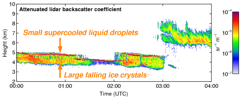
of clouds with much higher precision. Cloud lidar works in the
same way as radar but uses laser light. We make extensive use of the
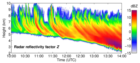
cloud radars and lidars at Chilbolton in Southern
England. As clouds are blown across the instruments, two-dimensional
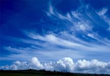
cross-sections are built up. An example from a cirrus cloud with
distinct fall-streaks is shown below. A photograph of a similar cloud
is shown alongside.
The principal challenge is to convert the raw measurements that the
instruments make into something useful like average particle size and
cloud water content. This is possible by combining the measurements
from two different active instruments. Combined radar-lidar
algorithms have been developed to obtain ice cloud
properties (7,18,28) and drizzle properties (19). Likewise, dual-wavelength
radar algorithms have been developed to derive ice cloud
properties (1,4) and liquid water content in
stratocumulus (20). Simpler
methods are possible if only one frequency is available, such as using
radar reflectivity and temperature to obtain ice water content (27).
We are now adapting these methods for use from space. The first
ever space-borne cloud radar, CloudSat, was launched
in 2006 by NASA, was accompanied by the "CALIPSO" lidar and numerous
passive instruments on the "A-train" of satellites flying in close
formation. The European Space Agency has
approved the "EarthCARE" satellite for launch in 2013, which would
carry cloud radar and lidar on the same platform. A novel
variational radar-lidar-radiometer retrieval algorithm has
been developed for use from the ground or from space (51,65). As part of this work,
computationally fast lidar and radar
multiple-scattering models have been developed (29,46,47).
Evaluating the clouds held in forecast models
Current weather forecast and climate models split the atmosphere
into boxes typically measuring 50 km horizontally and 500 m
vertically, and diagnose the fraction of each box that is cloudy. The
simplest use of radar and lidar data is to determine the location of
the clouds and verify model forecasts of
cloud fraction over the site. This has been done for the ECMWF model (6). The 10-day comparison below
demonstrates that the larger scale features are captured reasonably
well but there are differences in the detail at smaller scales.
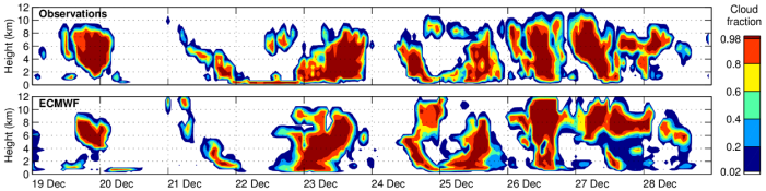
This work has been taken to a new level in the Cloudnet project, in which cloud
fraction, liquid and ice water contents have been evaluated in seven
European models and three sites (34). Cloud radar can be attenuated in
rain so we have used the lower frequency weather radar at Chilbolton
to evaluate the ice content above precipitation in the Met
Office model (23). We have also
used the space-borne ICESat lidar to evaluate clouds in the
ECMWF model using a lidar forward modelling approach (42).
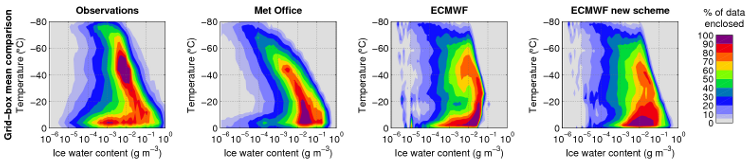
We have recently applied our variational radar-lidar retrieval
algorithm to CloudSat and CALIPSO observations
(65) and evaluated the global
distribution of ice water content in the Met Office and ECMWF
models (72). The results in the
figure below demonstrate that the Met Office model gets the average
about right for a given temperature, while the ECMWF model has an
unphysical "cut-off" where ice cloud is converted to snow and falls
out instantaneously. The new ECMWF scheme with prognostic snow
overcomes this problem.
The radiative impact of cloud structure on climate
Even if the cloud fraction were perfect in the model, the forecast
of cloud "cover" (the fraction of the surface that has some cloud
above it at any level) depends on the degree to which the clouds in
each level are overlapped. Most current models assume that clouds in
adjacent levels are maximally overlapped, while clouds separated by
entirely cloud-free levels are randomly overlapped. Analysis of cloud
radar data shows that clouds in adjacent levels are more randomly
overlapped than previously thought
(3), which has serious implications
for predicting cloud cover. One also has to consider the difference
between cloud fraction defined by area and volume
(24). Newer models are beginning to
predict the structure of the cloud properties within each box, which
is important for the interaction of solar and infrared radiation with
the cloud. We have used radar to derive the important cloud
variability and degree of overlap of cloud inhomogeneities
for ice clouds (10). We have
recently developed a new method "Tripleclouds" for representing
both cloud inhomogeneity and accurate overlap properties in model
radiative transfer schemes (44) and
used it to estimate the effect of cloud structure on the global
radiation budget
(59,60)
as well as implementing it in a free-running climate model
(70).
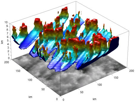
A technique has been developed to generate realistic 3D cirrus
cloud fields based on observed power spectra taken from cloud
radar observations. This has enabled the radiative effects of cirrus
to be calculated as a function of wind shear, which strongly affects
the orientation of the cirrus fall-streaks (21). An image of a fractal cirrus
cloud generated by our stochastic cloud
generator is shown below (see also the Intercomparison
of 3D Radiation Codes page).
 Three-dimensional radiative transfer calculations have been performed
to determine the radiative impact of
horizontal photon transport in stochastically generated
cirrus clouds (41). Similar calculations for
aircraft contrails reveal that their net radiative forcing, and
hence their effect on climate, are strongly dependent on the
inclusion of horizontal photon transport (39).
Three-dimensional radiative transfer calculations have been performed
to determine the radiative impact of
horizontal photon transport in stochastically generated
cirrus clouds (41). Similar calculations for
aircraft contrails reveal that their net radiative forcing, and
hence their effect on climate, are strongly dependent on the
inclusion of horizontal photon transport (39).
The physics of mixed-phase clouds
Mixed-phase clouds are those that contain both ice particles and
supercooled liquid droplets, and can occur between 0°C and
-40°C. Whether a cloud is composed of ice or liquid is crucial
for determining how much of the incoming radiation from the sun it
reflects back to space: liquid droplets tend be smaller and far more
numerous than ice crystals and so a liquid cloud tends to be around
10 times more optically thick than an ice cloud with the same mass of
condensed water. However, a lack of good observations means that
representation of mixed-phase clouds in models has tended to remain
very crude.
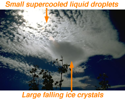
The strong reflection of sunlight by liquid water clouds means that
they also give a strong return to lidar. The figure below shows
typical data in altocumulus from ground-based lidar, in which ice
crystals can be seen falling beneath a very reflective layer
indicative of supercooled liquid water droplets. A photograph of a
similar altocumulus is shown on the right.
We have used lidar and other measurements from detailed case
studies to quantify the effect of mixed-phase clouds on the fluxes
of solar and infrared radiation (12). Long-term lidar measurements have
been used to estimate the frequency of occurrence of supercooled
clouds and compare with the distributions in the Met Office and ECMWF models (13). This work has since been extended
to space-borne lidar data (16). Combined aircraft and radar
measurements have been used to investigate the small-scale
distribution of ice and liquid in mixed-phase clouds (17) and the
role of the "Hallett-Mossop" process in mixed-phase stratiform rain
clouds, which can greatly increase the concentration of ice
crystals (8). These observations
have led to a number of high-resolution modelling studies (9,23,26)
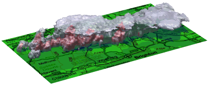
Observations of storms and precipitation
The weather radar at Chilbolton has a 25-m dish, which enables it
to probe storm clouds with unparallelled resolution. A new
variational method has been developed to use the
polarization capability to derive rain rate and hail intensity
with more accuracy than has been possible until now (35). The Doppler capability has been
used to derive the convective mass and momentum fluxes in a
line of cumulonimbus clouds (45). A
volume scan of the storms is shown below.

|