Please update your bookmarks with the new address.
The Record Wet Autumn of 2000 in Western Europe
Mike Blackburn and Brian Hoskins
The Autumn (Fall) season of 2000 saw record rainfall and widespread flooding in western Europe. It was the wettest Autumn in England and Wales since records began in 1766, and several regions from France to Norway received double their average rainfall.
This exceptional weather was linked to a persistent large-scale pattern of unusual conditions stretching across the Atlantic and northern Europe, the "Scandinavia pattern", with low pressure near the UK and a strong Scandinavian ridge. A regression analysis has shown that wet UK Autumns during the preceding 40 years were also associated with this pattern.
Using a simplified numerical model of the global atmosphere, our research suggests that the pattern was triggered by unusually dry weather over the tropical west Atlantic and South America in Autumn 2000. Experiments using this (barotropic) model have shown that anomalous upper-level convergence and sinking of air in this region in Autumn would give rise to a Rossby wavetrain remarkably similar to the observed pattern over Europe.
The "Scandinavia pattern" of the Autumn flow had been identified previously as one of a number of patterns of northern hemisphere variability by Barnston and Livezey (1987, Mon. Wea. Rev., 115, 1083-1126), but had not been associated with wet Autumns in western Europe. The pattern was originally named "Eurasian Type-1" by Barnston and Livezey but it has subsequently been renamed the "Scandinavia pattern" in an extended version of their analysis at NOAA's Climate Prediction Centre (CPC). It is CPC's index of the strength of the pattern that we have used in this study.
Variations in the winter climate of western Europe have been linked to a different pattern, the North Atlantic Oscillation (NAO), in recent years. Since the 1960s the positive phase of NAO, with strengthened westerly flow into Europe, has become more prevalent in winter. In Autumn 2000, however, the phase of NAO varied from month to month so that, in the seasonal average, the observed flow did not project strongly onto the NAO pattern. In contrast, the period of wet Autumn weather coincided with persistence of the Scandinavia pattern, from its onset in mid September until its decay in mid December. In the subsequent winter months, which have also been wetter than average in the UK, the wet periods have coincided with further occurrences of the Scandinavia pattern.
This work is being submitted for publication.
Copy of a less specialist paper submitted 10/2001 (pdf).
Poster accompanying a talk at the Royal Meteorological Society Conference 09/2001 (A4 size pdf) (A0 size pdf).
Copy of an article in the UGAMP Newsletter No 24, 03/2001 (pdf).
DEFRA webpage on Autumn 2000 flooding.
DEFRA report on causes of the Autumn 2000 flooding.
Environment Agency flood reports index.
"Lessons Learned" Environment Agency report on the Autumn 2000 flooding.
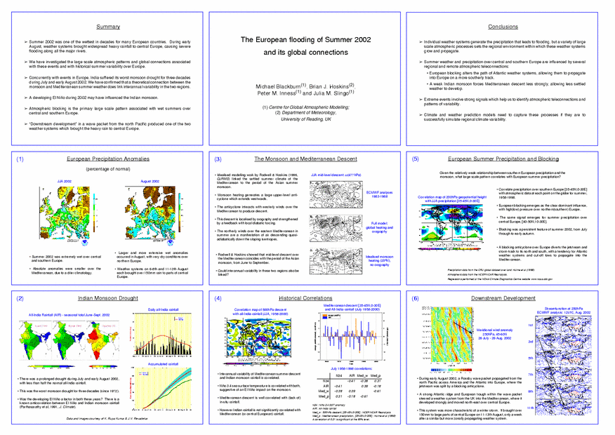
European Flooding during Summer 2002
Mike Blackburn, Brian Hoskins, Pete Inness & Julia Slingo
UGAMP Newsletter article containing preliminary results of a study into the European flooding and the Indian monsoon failure during Summer 2002
(PDF).
Article on the European flooding and monsoon drought of Summer 2002, from the latest edition of NERC's
Planet Earth publication
(PDF).
PDF version of a slide for the FREE meeting on Summer 2002.
Powerpoint presentation on 2002 European Floods, Indian Monsoon and ENSO (9.7Mbytes).
Monsoon online
UK Flooding-related links
DEFRA Flood Management information.
Environment Agency Flooding information.
Foresight: UK Government Foresight project on Flooding & Coastal Defence.
CEH water research theme.
FREE, Flood Risk from Extreme Events is a NERC directed programme.
FRMRC, Flood Risk Management Research Consortium is an EPSRC-led programme.
