 (courtesy of Mike Bench) the hail can be seen after it had been melting for about an hour; the hail caused damage to plants and glass roofs. (Jersey 22C, Avimeore 8C max, Altnaharra 1C min, Leeming 58mm, Clacton 12.3h.)
A cloudy night meant no early reports of air frost on the 2nd which dawned with bands of rain showers in many areas of the British Isles. These continued to affect all areas during the day, gradually dying out in the evening as winds gradually veered to a W or NW direction under rising pressure. Over Scotland, however, the winds remained cyclonic into the evening with MSL pressure at midnight being 977.1mb at Stornoway. Daytime temperatures of 8C or more were widespread across all the British UIsles, except at altitude. One person died, and one was severely injured when a landslide hit a beach road in Nefyn on the remote Lleyn peninsula in north Wales; The landslide reportedly swept seven cars over a steep embankment into the sea. (Guernsey 12C, Tain Bridge 0C, Tenby 18mm, Jersey 4.7h.)
Although skies cleared over most of the British Isles overnight, there was little air frost on the 3rd, due to the mainly W direction of the air flow. Cloud and showers soon developed over Ireland and W Britain by mid-morning with more general rain areas moving E later in the morning and into the afternoon. Falls were heavy in places in the Channel Islands, SW England and W Scotland; by midnight rain had spread to E parts of Britain. Gusts of 30-40kn were reported from W and S Britain. (Culdrose 11C, Redhill -1C, Lusa 30mm, Newcastle 5.1h.)
Another cloudy night meant little air frost on the 4th except in parts of Cent. and N Scotland. Rain continued to move E during the night, but it didn;t clear E England until early evening. The rain was followed by showers over S England and Wales and there a few showers over W Scotland during the day. Skies cleared a little over Ireland during the evening, while another area of rain began affecting SW and Cent. S England later in the evening. (Guernsey 12C, Loch Glascarnoch -2C, Tiree 21mm, Falmouth 6.8h.)
A complex area of low pressure centred over the British Isles resulted in a mainly cloudy day on the 5th. There was an air frost over parts of inland Ireland and N Scotland, while fog that formed around dawn over E Ireland then persisted for most of the day. There was rain overnight in the Channel Islands and parts of S England which moved E during the morning, and there were bands of rain affecting Scotland and SW Ireland at times during the day. (Herne Bay 11C, Altnaharra -4C, Guernsey 21mm, Prestatyn 4.3h.)
Following the clearance of cloud overnight, the 6th began with mainly clear skies over much of England and scotland, away from some W and SW coasts. Fog over Ireland cleared to mist overnight. Bands of light rain and showers affected most parts of the Iritish Isles during the day, although it was a very sunny day in some parts of E England and East Anglia. (Saunton Sands 12C, Aboyne -5C, Prestwick 14mm, Skegness 7.2h.)
The 7th dawned with little cloud over the S half of Britain and Ireland, with rain and showers over N England, N Ireland and parts of Scotland (where there was also an air frost in parts of the N). These conditions persisted for much of the day, with some heavy rain at times over N England, although there were also some showers over W and SW parts of England and Wales, and as far S as The Wash in the E. (Torquay 11C, Kinbrace -5C, Keswick 13mm, Clacton 7.1h.)
Despite patchy cloudy early on the 8th there was a widespread ground frost across the British Isles, away from W coastal districts. Many places had a dry day, although there were showers throughout the day and into the evening that brought rain to some areas. (Penzance 11C, Redhill -4C, Buxton (Derbys) 20mm, Falmouth 7.4h.)
There was a widespread ground frost across the British Isles on the 9th away from coastal areas, with some mist and fog patches. Any fog cleared during the morning and the day was then mainly dry in most areas, with sunny spells in N England, N Ireland and Scotland. S England and Wales tended to be rather cloudy throughout the day, and it felt cool in the E wind. There were some light showers during the day although during the evening more extensive rain spread to the Channel Islands, with E winds gusting to 30kn. (St. Marys 9C, Strathallan 0C max, Braemar -4C min, Altnaharra 1.5mm, Aspatria 4.9h.)
Clear skies over Scotland and Ireland led to a frosty start on the 10th there, while other reas had a mainly cloudy start with fresh E winds and rain along the English Channel. It remained bright over Ireland and Scotland during the day, with clearer skies spreading to N Wales and NW England later. There were a few snow showers over Cent. Scotland and Cumbria, while rain affected extreme S districts of England, and the Channel Islands, for much of the day; amounts were heaviest in Sussex and Kent. (Jersey 9C, Aviemore 1C max, Loch Luichart -7C, Hastings 13mm, Tiree 6.8h.)
Clear skies led to a sharp frost in parts of Scotland on the 11th, with air frost in parts of Ireland and N England. Over S England a fresh/strong E wind under cloudy skies made it feel cold throughout the day; rain fell over the Channel Islands throughout the day, and in parts of coastal counties of S England from time to time. At Guernsey Airport, the 24-hour rainfall total beginning 0900GMT of 35.8mm beat the record of 32.3mm for 5 January 1959; overall this was the 25th highest daily total on record. Despite sunny spells over the N half of the British Isles, temperatures remained below freezing over parts of Scotland all day. Pressure rose steadily over Scotland throughout the day, reaching 1035.8mb over the Highlands by midnight. (Guernsey 9C, Tulloch Bridge -8C, Jersey and Hastings 16mm, Tiree 6.8h.)
High pressure dominated the weather over the British Isles on the 12th, with MSL pressure reaching 1036mb over the Highlands at 0900GMT. Clear skies over N and W parts of the British Isles led to a widespread air frost here, followed by a sunny day, with the temperature only just rising above 0C in parts of Scotland. Further S and E the day was cloudier, with a fresh E wind in the extreme S continuing to make it feel cool, and with rain at times in SW England and the Channel Islands. The rain disappeared during the evening in the S, with cloud confined to parts of E England by midnight. (St. Marys 9C, Strathallan 1C max, Aviemore -9C min, Teignmouth 23mm, Bognor Regis 7.3h.)
The 13th was a mainly dry and inticyclonic day everywhere. There was a widespread ground frost overnight, with a sharp air frost in parts of N Scotland. There then followed a mainly sunny day, albeit with some rain in SW Ireland, before temperatures again started to fall during the evening with further frost developing. MSL pressure reached over 1040mb at midnight in Northumberland. (Llanbedr 10C, Tain Range -1C max, Altnaharra -9C min, Torquay 2mm, Hastings and Newquay 7.9h.)
Almost clear, anticyclonic conditions overnight meant another widespread frosty start on the 14th. There was freezing fog in parts of Yorkshire and the E Midlands, which persisted all day in parts of Yorkshire keeping the temperature below 0C. Thirty-one vehicles have been involved in a series of pile-ups in thick fog on the A1M at Doncaster; 17 people were taken to hospital to be treated for minor injuries. Elsewhwre there was very little cloud during the day, although some affected parts of E England during the evening. MSL pressure rose to 1040.5mb at Whitby at 0900GMT. (Aultbea 9C, Linton-on-Ouse -1C max, Altnaharra -11C min, Lough Fea 0.5mm, Newquay 8.2h.)
Low cloud spread W across the E half of England before dawn on the 15th, preventing temperatures here from dropping much below 0C. Elsewhere, clear skies and dry air resulted in a widespread frost away from coastal areas, while patchy fog was present for a while in NE England. Although low cloud persisted over much of England until middday, and for a while over Ireland, there was no measurable precipitation during the day, and temperatures remained below 0C in parts of E Scotland despite the sunshine. During the evening more cloud spread NE across SW England. (Torquay 9C, Perth and Kinross -1C max, Altnaharra -12C min, no measurable precipitation, Fishguard 7.6h.)
Away from S Ireland SW England (where there was patchy cloud), coastal regions and the Northern Isles, the 16th danwed with a widespread frost. There then followed another mainly dry and sunny day; cloud in the SW was accomapnied by light snow and snow grains in places, while over NE England there was some patchy cloud and fog patches. Mist and cloud spread N to affect much of Ireland by the evening, and temperatures remained close to freezing in many parts of Britain despite the sunshine. (Falmouth 8C, Drumalbin -2C, Altnaharra -12C, Isle of Portland 1mm, Hunstanton 7.1h.)
Another mainly clear night led to further widespread air frost away from the coasts on the 17th, while parts of SW England, S Wales and S Ireland began with cloud and sleet. This precipitation band pushed very slowly NE before fragmenting during the afternoon, while still over SW England, after a heavy thunderstorm in S Cornwall. In Penzance, after a night with brief but sharp showers, there was an intense thunderstorm which dropped in excess of 35mm between 0615 and 0815GMT. The bulk of this probably fell within 1 hour. This storm was quite large in area. Many roads were flooded, the main A30 just west of Penzance was impassable for a time, and there was floodwater near Newlyn. There was also significant flooding at Hayle. There was some freezing fog during the day in the E Midlands; at Keyworth today was a second day with the countryside coated in thick rime after freezing fog and minima down to -6.2C and -6.3C respectively - the lowest readings since January 1997. Elsewhere, the day was mainly dry and sunny, apart from some cloud in E coast areas of England and Scotland. (St Marys 10C, Altnaharra -4C max, Altnaharra -14C min, Penzance 40mm, Hunstanton 7.4h.)
The 18th dawned with low cloud along E coast areas of Britain, low cloud in parts of S England, a widespread frost away from the coasts and freezing fog patches in the E Midlands and Cent. S England. Overnight light snow over the Highlands continued during the day, with falls in E Scotland and the Northern Isles also. There were also reports of rain in SW England during the morning (this being heavy and continuous for a while in S Devon), while light snow also fell in the Midland, Yorkshire and the Pennines. (St. Marys 9C, Altnaharra -1C max, Altnaharra -12C min, Torquay 6mm, Fishguard 7.5h.)
It was cloudy overnight in many E regions of Britain, with snow over Yorkshire and the Highlands before dawn on the 19th. There was also snow, and some fog, around dawn in the E Midlands, with light snow also on the high ground in Cent. S England and in the Thames Valley. It remained cloudy in the E half of Britain, with further light falls of snow in places, while over Ireland there were fog patches during the day. Other W districts had sunny spells. (Guernsey 8C, Warcop -1C max, Redhill -8C min, Scarborough 8mm, Prestatyn 7.1h.)
Low pressure over the North Sea on the 20th led to another cloudy day in E districts, with some snow again as far S as the Thames Valley, and with persistent fog during the day in parts of E England and East Anglia. Clear skies in the W half of the British Isles led to a sharp frost in parts of Scotland, followed by a mainly sunny day in these areas until cloud and rain pushed E into Ireland during the afternoon and evening. The rain spread to SW England and W Wales by midnight, with some snow over the mountains of W Wales. (St. Marys 10C, Aviemore -2C max, Aviemore -10C min, Loftus 7mm, Weymouth 7.4h.)
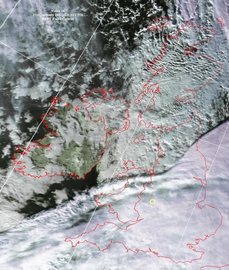
Overnight the precipitation band continued to spread E, reaching London and SW Scotland by dawn on the 21st, with snow falling along much of the leading edge over England. Fog formed in the clearing skies behing the rain over Ireland, and ahead of the snow over E England. By 1130GMT lying snow had reached a depth of 4cm at High Wycombe. By mid-afternoon the rain and snow had almost cleared E England and E Scotland, although there continued to be extensive precipitation over the English Channel until late evening. By midnight the temperature had risen to 9C over much of S Ireland, with some further rainfall there there in a moist S airflow, while fog formed across much of Cent. S and E England. The 1235GMT NOAA 16 satellite image shows a remarkable view of the rear a cloud band associated with the snowfall. (St. Marys 12C, Bingley 0C max, Aviemore -7C min, Eastbourne 25mm, Torquay 7.4h.)
Rain in the W pushed E during the night and throughout the 22nd, bringing warmer air and S winds gusting to 40kn in many areas (in N Scotland gusts to 60kn were reported). The rainfall was heavy in Northern Ireland and parts of S Scotland, and widespread cloud throughout the day meant little in the way of sunshine. Pressure fell during the day, with Belmullet reporting 973.2mb at 2100GMT. During the evening there was a partial clearance of the cloud in some W areas, as the rain gave way to showers. (Chivenor 12C, Aviemore -3C, Lough Fea 25mm, Newquay 1.7h.)
There was little frost on the 23rd, despite the rainband clearing E England before dawn and being followed by clearer skies. Rain lingered over N Scotland where winds continued to gust to 60kn before dawn. By mid-morning further rain had begun to push NE across S Ireland, Wales and SW England and this rapidly extended to affect most of Britain by the evening, by which time time rain showers had followed behind the band to cover most of Ireland. Winds gusted to 60kn across the British Isles accompanying the rain. As the showers spread across England during the evening they turned thundery in Cent. S England and the Midlands. With a low centre moving across Northern Ireland and Scotland during the day, MSL pressure fell to 958.6mb at Belmullet at 1500GMT. (Torquay 12C, Redesdale and Cranwell -3C, Shap Fell 23mm, Skegness 2.0h.)
The 24th was another mild day, with sunny spells over much of England and Wales, but with bands of rain and showers affecting W and N parts of the British Isles.Some of these showers were heavy, and there were reports of hail from W Ireland. Winds gusting to 30kn were quite widespread, with gusts to 50kn in Scotland and W Ireland. At Dun Laoghaire the sea temperature dropped below 6C for the first time for a number of years. (Penzance 12C, Altnaharra 0C, Shap Fell 20mm, London Weather Centre 7.6h.)
Rain and showers affected many W and N parts of the British Isles on the 25th, with rain also in S England before dawn. In between the showers (which were of hail and snow in N and Cent. Scotland), most areas had long, sunny spells. Winds were quite gusty during many of the showers, with gusts to 50kn in N Scotland. Over W Ireland, the hail showers also occurred, with some thunderstorms during the late morning and early afternoon. Heavy hail was also reported from Southend, and with watertables still high after the autumn rains, there were reports of localised flooding in parts of S England after recent rains. (Falmouth 11mm, Loch Lucihart -2C, Capel Curig 16mm, Oxford 7.3h.)
A W airflow meant that 26th began with relatively mild conditions everywhere, with rain and showers in W districts. Some of these showers were of hail and snow. The showers persisted throughout the day, with sunny spells in most E areas, and more general frontal rain and snow over Scotland. By midday another area of rain had pushed NE into SW England; this moved NE during the afternoon and evening, turning to snow in Oxfordshire, Berkshire and areas N and E of here. There was also heavy snow over Dartmoor. The airport at Luton was closed because of the snow and blizzards on the M40 between Handy Cross and Watlington, Buckinghamshire, and Oxford and Wendlebury reduced visibility. The Met Office apologised for failing to correctly predict the snowfall in the south east; a spokesman said: "We decided it was going to be mainly on higher ground, but we had larger areas of heavy rain than predicted, which then turned to snow." Rainfall amounts in the S were large in many areas, leading to more localised flooding. (Guernsey 10C, Knockarevan 1C, Lusa 27mm, Colwyn Bay 7.0h.)
The rain and snow in the S cleared the E coast by about 0300GMT on the 27th, and the night was then mainly clear and dry apart from some light precipitation in Scotland. There were icy patches in the s after the recent rain, and one man died after a car skidded on ice near South Brent, Devon, in the morning. The day remained mainly dry over most of England and Wales with sunny spells. There was some light rain for a while in E England, while rain also fell over W parts of Scotland and Ireland. (Guernsey 11C, Topcliffe -2C, Hemsby 21mm, Eastbourne 8.2h.)
Clear conditions overnight led to a frosty start to the 28th away from coastal districts. Muchn of Britain and a day of sunny spells, with light rain and showers over Ireland and W Scotland. There was patchy fog over SW Scotland and NW England from time to time. (St. Marys 11C max, Baltasound 6mm, Norwich 6.9h.)
Following a mainly clear night there was a widespread air frost on the 29th away from coasts, with mist and fog in parts of N England and the Midlands that still lingered by dawn. During the morning cloud and rain spread E into W Ireland, and this moved slowly E during the remainder of the day, reaching SW Scotland, Wales and SW England by midnight. Much of scotland and E England had a sunny day, although there was patchy cloud in some parts of the S and East Anglia for a while. (Torquay 11C, Redesdale -6C, Lerwick 5mm, Scarborough 7.7h.)
Clear skies over much of Scotland led to a sharp air frost in places there on the 30th, although in S Scotland and areas to the S the night soon turned cloudy as rain spread from the W. In some E and Cent. areas of England the rain arrived around dawn with the temperature close to 0C, leading to some icy roads. Bands of rain were slow-moving throughout the day, giving most of Ireland, Wales and England a damp, dull day with mist in places. The best of any sunshine was in N Scotland, although even here there was some light rain. During the evening air frost developed again in N Scotland, with fog forming across Cent. England. (Torquay 13C, Glenlivet -6C, Mumbles 12mm, Kinloss 5.6h.)
The 31st dawned cloudy and cold over E districts of Britain, with light rain or drizzle in places, and fog from NE England to Cent. S England. There was also early fog over Ireland and cloud in other areas, except for N Scotland where there was a sharp frost in places. The fog was slow to clear in parts of Ireland and E England, and it remained mainly cloudy with a few spots of light rain across most of the British Isles during the day. An exception to this was N and E Scotland, which had a sunny day; during the evening clear skies spread S to the Midlands, leading to thick freezing fog in places by midnight by which time organised light rain had reached W Ireland from the W. (Teignmouth 12C, Altnaharra -6C, Folkestone 5mm, Lerwick 7.0h.)
Most areas began the 2nd with cloudy conditions, with light rain and drizzle in E and S parts of England and Ireland, and showers in the W. Early fog patches in Yorkshire and the Midlands soon cleared after dawn, and although it remained mainly cloudy across the British Isles precipitation became mainly confined to E areas. During the afternoon and evening, however, further rian spread e across Ireland and into W Scotland and SW England. In the Northern Isles there were snow showers and gusts to 50kn during the day. (Penzance 12C, Lerwick 3C max, Fylingdales 0C min, Wick 16mm, Penzance 5.3h.)
With low pressure over N England and SW Scotland for most of the 3rd, weather conditions in NE Britain were dominated by a strong SE wind, while in the SW lighter SW airflow occurred. Much of Britain had a damp and cloudy day, with rain and drizzle in the S and W and sunny spells over Ireland and Wales before further rain pushed Ne into Ireland during the evening. To the N of the low centres snow fell over N and E Scotland, with gusts to 50kn leading to some blowing of lying snow and temperatures close to 0C all day. At Forfar the Scottish league football match was abandoned due to snow. (Hastings 12C, Baltasound -1C max, Sella Ness -2C min, Capel Curig 21mm, Anglesey 4.3h.)
The north-south split in weather conditions continued throughout the 4th, with snow falling as far S as the Pennines and Yorkshire, and much of scotland, away from the SW, having temperatures around 0C for most of the day. Snow depths reported at 1800GMT included 27cm at Lerwick, 13cm at Eskdalemuir and 7cm at Aberdeen; at 2200GMT Copley was reporting 25cm of level snow. Snow led to the cutting of electricity supplies with over 1000 customers between Wick and Aberdeen affected. Drifting snow forced the closure of many minor roads and made a number of major A roads impassable, particularly in the Borders and grampian regions. Scotland's ski resorts were forced to close due to high winds and drifting snow. The league football match at Newcastle was cancelled due to snow, while sleet fell as far S as Norfolk during the morning. In the S, there was steady rain for many hours in several places, with gusts to 40kn in parts of S England, and a severe flood warning was issued for the River Kym in Huntingdonshire. A teenage boy also lost his life when he was swept into the North Sea as he walked along the coastline at South Gare, Co Durham, in the afternoon. The minimum temperature at Lerwick equalled their absolute minimum February temperature. (Torquay 12C, Loch Glascarnoch -2C max, Lerwick -7.3C min, Pembrey Sands 27mm, Anglesey 1.7h.)
Further snow continued to fall throughout the night across much of Scotland and N England, with falls in Northern Ireland also. Snow depths at 0600GMT on the 5th included 19cm at Eskdalemuir. Rain over much of S and W Britain during the morning moved slowly E during the day, with rising temperatures leading to a later thaw in Northern Ireland; another belt of rain pushed into SW England and S Ireland during the evening, and moved NE during the evening. Winds were again gusty over England and Scotland, with a mainly E flow over Scotland and a SW flow over England. Ice and snowdrifts of up to 6 metres left thousands of homes in Scotland and northern England without power on, and closed dozens of schools and roads. Roads were closed throughout Scoptland and many people were left without electricity after blizzards brought down power lines. The east coast and Northern Isles were badly affected, with all schools in Shetland and 65 in Grampian closed. Further south, there were 67 flood warnings in place at one point during the day; the Cam in Cambridge is higher than most people have seen in it nearly 30 years. (Torquay 13C, Lerwick -2C max, Baltasound -4c min, Morecambe 17mm, Anglesey 6.2h.)
Further snow on the 6th in N and Cent. Scotland, accompanied by strong E winds, continued to cause problems, although wamrer air pushing up from the S meant that thawing became a problem in S Scotland. Further S there were heavy showers during the day, some of these blustery and accompanied by hail. Over S and Cent. England, and S Ireland thunder was also widely reported with gusts to 50kn during the showers. A coastguard helicopter was called to airlift a five-month-old girl to hospital because the bad weather was making it impossible to take her by road; he was flown from Lochinver in Sutherland to Stornoway where she was then taken to the Western Isles hospital. A train travelling N from Inverness at about 1130 GMT on Tuesday with a locomotive snow plough on the front became stuck after it hit a wall of snow. A second train travelling in the opposite direction also became stuck as it tried to head back from Thurso to Wick after ScotRail decided to abandon the service; passengers than had to endure a six hour wait before rescue arrived. Another train was derailed in appalling conditions a mile and a half south of Blair Atholl, Perthshire. Undrifted snow depths of around 60cm were reported from near Aboyne. There are unconfirmed reports of a tornado, SE of Guildford, during the evening. The minimum temperature at Baltasound was reported to be an all-time low for Shetland. (Poole 14C, Loch Glascarnoch -1C max, Baltasound -11.9C min, Charterhall 27mm, Hunstanton 7.2h.)
There was further snow overnight in N Scotland and on high ground in Cent. Scotland, while by dawn on the 7th milder air had pushed N to bring rain and sleet to E Scotland. There was a slow-moving area of rain over S Scotland, N England and N Wales for much of the day, with sleet/snow on the N edge and over high ground, while further S there were rain showers. Snow showers continued to affect N Scotland during the day, although in the evening there was a general clearance of cloud over Scotland and much of Ireland, with widespread rain over much of S England. On Shetland the island two supermarkets were beginning to run out of food due to disruption to the ferries, and schools on the island have been closed for three days. There were no train services north of Inverness after two trains got stuck in 10ft snow drifts near Kinbrace. Around 120 schools in Grampian were closed, many for a third day. On the roads, conditions were reported to be poor in the far north of the country due to further heavy falls of snow. The river Tees flooded Croft/Hurworth Place today, while the river Swale has flooded at Morton-on-Swale, and yet again the Ouse has flooded York. (Chivenor and London 13C, Sella Ness 0C max, Altnaharra -6C min, Capel Curig 32mm, Hunstanton 7.2h.)
An area of rain was slow to clear, eastwards, S England and the Channel Islands during the morning and early afternoon of the 8th, while a second area of heavier rain affected SW England and the Channel Islands during the afternoon and evening. On the N edge of the rain, snow was observed in W Cornwall shortly after dawn. Falls of over 25mm were widespread, with Manston having 36mm between midnight and 0600GMT, almost equalling the 40mm monthly average for February. There was widespread flooding in Kent by the evening in Kent. Elsewhere, much of England had a cloudy night with light rain in the NE, with the remainder of the British Isles being largely clear of cloud (apart from a few snow showers over N Scotland) leading to a sharp frost in Cent. Scotland. This cloud distribution persisted throughout the day, with sunshine over Wales, Scotland and Ireland, and some snow showers over N Scotland. The first 8 days of the month have resulted in over 175% of the normal February monthly rainfall in parts of Kent and Sussex. (Culdrose 9C, Altnaharra 1C max, Tulloch Bridge -11C min, Folkestone 55mm, Belfast 8.4h.)
Heavy rain in the Channel Islands overnight turned to sleet around dawn on the 9th, before clearing to the E. Elsewhere, the British Isles had a mainly dry and clear night, with a sharp frost in parts of scotland and Cent Ireland. Apart from some coastal showers in W Scotland (and snow showers in parts of N Scotland), it remained mainly dry until the evening, when rain pushed E across much of Ireland. There was widespread flooding reported from both Jersey and Guernsey - fortunately most of it in unpopulated areas, but a number of houses in St Peters Valley in Jersey were been flooded. (Torquay and Lee-on-Solent 10C, Loch Glascarnoch -4C max, Loch Glascarnoch -13C min, Jersey 37mm, Torquay and Aberdeen 8.3h.)
The rain, accompanied by S winds gusting to 50kn in places, continued to push E throughout the 10th across most of the British Isles, resulting in a mainly cloudy day after dawn. There was a sharp frost in N Scotland ahead of the rain, the temperature at Altnaharra rising from -14C at 0000GMT to 0C at 0300GMT. There was some snow and sleet ahead of the rain in Scotland and N England, and a general rise in temperature everywhere. During the evening the rain gave way to drizzle and fog in S Wales and SW England. (Chivenor 13C, Altnaharra -15C, Shap Fell 27mm, Herne Bay 1.0h.)
With extensive cloud overnight, the 11th dawned mild in most places. It remained cloudy, away from N Scotland, throughout the day, with further spells of rain, especially over N England and S Ireland. Gusts of 30kn were widespread, evcen in E England where pressure was fairly high (eg. 1028.8mb at Manston at 1200GMT). During the evening the rain area edged S, allowing the cloud clearance to spread S over much of W Scotland. (Guernsey 14C, Bridge of Cally -1C, Capel Curig 41mm, Lerwick 2.9h.)
Overnight cloud in the S and mild SW air in the N meant that the 12th dawned free of frost everywhere. In fact it was an unusually mild night in the SE corner of England. At Stratfield Mortimer the 09-09GMT minimum was 10.5C, the highest February value in this area since at least 1971. By dawn there was rain falling across S Ireland, S Wales and SW England, which pushed E and SE during the day. Falls were heavy in places, laeding to localised flooding across the Midlands and S. In S Wales the River Neath has burst it's banks in Resolven and Abergarwed, with some 30mm falling at Cardiff (Llandaff). In Gloucester a total of 27.7 mm fell in a period of about 9 hours including 7.2 mm in 40 minutes. Scotland and N parts of Ireland has a sunny day, and these clear conditions extended S as the rain cleared SE England. By midnight anticyclonic conditions resulted in MSL pressure rising to 1038.3mb at Cork. (Teignmouth 13C, Aviemore 2C, Oxford 27mm, Leuchars 8.1h.)
High pressure over the British Isles on the 13th meant an almost cloud-free for some areas in the S, with MSL pressure rising to 1040mb at 0900GMT over the Welsh Marches. Despite the clear skies, air frost was mainly confined to parts of NE England and the Midlands, and these areas also saw fog during the morning. There was patchy cloud over parts of Scotland and N England for a while during the afternoon and evening, before another clearance led to some mist and fog over Cent. England by midnight. (Lee-on-Solent 13C, Topcliffe -5C, Folkestone 6mm, Weymouth 9.2h.)
Pressure remained high everywhere on the 14th, which dawned with mainly clear skies, a widespread air frost over England and Wales, and fog over much of Cent. S England, the Midlands and NE England. The fog persisted all day in parts of Yorkshire; elsewhere the day was mainly sunny with little cloud, although there was some light rain during the morning in the Shetland Islands. During the evening some frontal cloud and light precipitation affected W Ireland and W Scotland. (Trawscoed 13C, Dishforth 1C max, Dishforth -7C min, Spadeadam, Southsea, Watnall and Chivenor 0.5mm, Saunton Sands 9.8h.)
Anticylonic conditions again prevailed during the 15th across the British Isles, with MSL pressure reaching 1037mb at Valentia by the end of the day. Northern parts tended to be rather cloudy, however, as a weak front moved SE across Scotland into Wales and N England, giving patchy falls of light rain. This rain did become heavier over N Wales and Lancashire during the evening. Further S the day was mainly sunny, once early widespread fog over SE England and East Anglia had cleared; the fog did linger for much of the day in parts of Lincolnshire. (Watnall 13C, Wainfleet 4C max, Shawbury -5C, Lusa 2mm, Hastings 9.1h.)
High pressure again dominated the weather on the 16th, although a weak cold front crossed SE through England and Wales during the day. After a frosty start in many areas, with fog across parts of S England, rain over N England and Wales moved SE, finally clearing E England by early evening. Pressure rose, and skies cleared to the rear of the front, and many areas had a sunny day. During the evening cloud and light rain affected N Scotland, although pressure rose to 1043mb at Dublin by midnight. (Falmouth 13C, Redhill -5C, Lerwick 4mm, Falmouth 9.2h.)
The 17th dawned mainly clear, with s widespread air frost. There was extensive thick fog from Lancashire to Dorset, with some light rain and drizzle over N Scotland. MSL pressure rose to 1046.2mb over Wales during the day, the highest reading for February since 1979. Although cloud was patchy in places, many areas had a sunny day, and the rain in the N soon cleared. Fog reformed over the Midlands in the evening. (Falmouth 13C, Lisburn -6C, Barra 2mm, Hunstanton 9.4h.)
The 18th was a largely dry day everywhere, as high pressure maintained its hold. Early fog again affected many parts of the Midlands, parts of N England and Cent. S England, and where it lingered for much of the day temperatures remained low. Most areas had a sunny day after the clearance of the fog, although cloud spread from the W to affect much of Scotland and Ireland during the day. (Guernsey 10C, Sennybridge -6C, Little Rissington 0.5mm, Newcastle 7.5h.)
There was again widespread fog over Cent. and S parts of England by dawn on the 19th, while early cloud over Scotland and Ireland was accompanied by light rain and drizzle. The fog was slow to clear from S England, and much of the British Isles then had a cloudy day despite the persisting high pressure, with drizzle spreading to N England and Wales during the day. (Penzance 11C, Redhill -6C, Lusa 7mm, Torquay 9.2h.)
The 20th was a mainly cloudy day, with early fog in parts of the Midlands and S England. There were falls of light rain and drizzle over Scotland and Ireland, which spread SE to Wales, the Midlands and SW England during the afternoon and evening. (Tain Range 12C, Topcliffe -3C, Loch Glascarnoch 2mm, Isle of Wight 7.8h.)
Early rain and drizzle over Scotland, Ireland, N England and Wales spread slowly S on the 21st, with showers of rain, hail and snow falling in the colder air over Scotland during the day. Early fog over S Wales and SW England was slow to clear in places, while much of the S half of the British Isles (except for SW England) had a rather cloudy day. Even in SW England there were some notable local variations in the weather: in Mount's Bay, with very little wind and unbroken sunshine from 0930GMT the temperature rose to 14.4C; on the north coast of Cornwall (only 4-5 miles away), there was a good deal of low cloud and temperature near 9C. (Penzance 15C, Lerwick 5C max, Redhill -1C min, Altnaharra 3mm, Teignmouth 9.1h.)
Light rain and drizzle, preceded by early fog patches in Cent. S England, pushed S across S England and S Wales during the morning of the 22nd, while another area of light precipitation, initially over Northern Ireland, made progress S and E during the day, reaching S districts by midnight. Much of the British Isles had a cloudy day as a result of the rain areas, with the best of any sunshine over Scotland. where showers of hail, sleet and snow were also widespread. (Cardiff 13C, Baltasound 1C max, Baltasound and Lerwick -1C min, Wick 10mm, Leuchars 7.6h.)
Wintry showers continued to fall over N Scotland before dawn on the 23rd, while an area of light rain and drizzle, followed by rain showers, affected S England, S Wales and Ireland into the morning and afternoon. Showers of hail and snow fell as far S and N Wales during the day and although skies cleared in most parts of the British Isles during the evening, it remained cloudy over E England with snow falling over Yorkshire and Lincolnshire, and gusts to 50kn recorded. Snow showers were also reported in the evening from Surrey and Powys, while thunder accompanied snow showers in Stoke in the afternoon. In S Wales, showers of hail/rain/sleet turned to snow over the A465 above 300m asl with a thin covering over some of the hills near Merthyr and Aberdare. (Culdrose 10C, Fylingdales -4C, Colwyn Bay 6mm, Hunstanton 9.4h.)
The snow in NE England cleared overnight (leaving depths of up to 10cm in places), but snow showers continued over Scotland during the early hours of the 24th. Wintry showers also fell before dawn and into the morning in Surrey and Essex. There were widespread wintry showers, with blowing snow, over N Scotland during the day which led to the cancellation of some Scottish League football fixtures. Widespread snow also fell over N England, N Wales and in parts of the Midlands, these spreading to high ground in Cent. S England during the evening. Away from the showers, it was a sunny day. Light snow flurries were observed on Jersey during the evening. Snow fell in Cirencester between 2200 and 2240Gmt settling to a depth of 1cm. (Newquay 9C, Tulloch Bridge -8C, Lerwick 6mm, Weymouth 10.0h.)
There were widespread falls of light snow across S England before dawn on the 25th with more falls in N Scotland. Snow continued to fall across N Scotland throughout the day while an area of cloud and rain pushed into Northern Ireland early in the morning, later spreading E and S. After a bright, cold, start to the day, it turned cloudy over most of Britain during the day. (Scilly 7C, Sennybridge -8.8C, Wick 4mm, Littlehampton 9.8h.)
Despite the generally cloudy start to the 26th there were some very cold spots over Scotland. Rain over Ireland continued to push across England and Wales during the day, followed by showers in the W. Ahead of the rain there was some snow over E England and Norfolk, and in N Wales, while sleet and snow was also seen on some high ground in S Wales and S England as the rain passed. During the evening rain turned to sleet and then snow over Northern Ireland. Over Scotland rain in the W before dawn soon turned to snow as it spread E with heavy falls over Cent. and S areas, and drifting in a strong NE wind gusting to 40kn. Showers of hail and snow fell later in W Scotland. As the snow over Ireland spread S during the evening, it was accompanied by thunder and lightning around Dublin, while around Cork power lines came down due to high winds with 500 homes affected. Snow caused all 24 schools in the Western Isles and on Orkney to be shut and heavy snow led to the closure of many northern airports. Conditions on many roads were described as treacherous, with up to 15cm of snow falling overnight in the Northern Isles. In Aberdeenshire a handful of schools were closed as a result of the weather. By the afternoon snow depths included 19cm at Kirkwall and 12cm at Aberdeen Airport. (Scilly 9C, Altnaharra -1C max, Glenlivet -9C min, Ronaldsway 16mm, Herne Bay 6.6h.)
Heavy snow and high winds brought many parts of Scotland to a halt by morning on the 27th, with the severe conditions also spreading to Northern Ireland, N England and parts of E Eire. The Met Office issued an emergency flash warning of "exceptionally severe weather" during the morning. Heavy snow in S Scotland was accompanied by NE gusts to 60kn. Wintry showers and blowing snow affected N Scotland. Across Cent. and S England precipitation amounts were small, with showers rain and hail, and snow fell over some of the higher ground here. Sleet and snow fell over much of N England, N wales and in parts of the N Midlands, with thunder reported in the Manchester area. Snow was reported as far S as the Channel Islands. Virtually all areas of Scotland were affected by snow and the problems on the roads were compounded by severe drifting. As many as 100,000 homes were reported to be without power after winds brought down power lines. All 150 schools in Edinburgh are closed, affecting 50,000 pupils. Every single road in the Borders was closed by snowfall. Both the east and west coast main railway lines were closed by snow. After 31 hours of non stop snowfall near Motherwell accumulated depths were approximately 50cm, with 3m drifts in places, by midday; in the early hours conditions were very severe with visibility down to 50m in heavy falling snow and blowing snow. The M8, Scotland's busiest motorway, was blocked completely for more than 10 hours, with hundreds of motorists stranded in their cars. More than 300 people spent several hours in the evening and into Wednesday stuck in snow on the M74 motorway between Abington and Crawford, in South Lanarkshire, as rescuers struggled to get to them. In Yorkshire, Trans-Pennine routes were badly affected, with the Snake Pass and Woodhead Pass forced to close. Edinburgh and Dublin airports were closed for much of the day. Snow depths by the evening amounted to to 1cm at Dun Laoghaire and 10cm inland of Dublin. Other reports included 20cm at Copley (2200GMT). During the evening skies cleared over much of Scotland and Ireland, and temperatures fell. (Penzance 9C, Eskdalemuir -1C max, Lerwick -4C min, Eskdalemuir 27mm, Saunton Sands 7.5h.)
The 28th dawned mainly clear over Scotland and Ireland, with a sharp frost in places. Snow and sleet fell in N England and N Wales overnight, with some falls as far S as Sussex. Boltshope Park (Durham) had 33 cm of snow lying at 0900GMT. Thousands of homes in NE England were without power overnight, while supplies were also affected in Northern Ireland, where about 15,000 houses were still waiting to be reconnected. Cloud soon developed ovre Ireland and Scotland, and many areas of the British Isles had another day of snow and hail showers, with more persistent rain falling in S England; however, even here the rain turned to sleet or snow for a while in many areas. On the North Downs there were accumulations of 3cm. During the evening thunderstorms occurred in Scilly and SW Cornwall. (Jersey 8C, Drumalbin -1C, Loch Glascarnoch -13C, Clacton 14mm, Belfast 9.0h.)
The 2nd dawned with a widespread air frost and very low temperatures in N and Cent. Scotland. At Pitroddie -9.5C was the lowest for any month during the previous 10 years. At Dun Laoghaire -4.2C was the lowest reading in March for 15 years. Early cloud over E England was accompanied by snow showers in places - these continued during the day and affected parts of the Midlands, Cent. S England and Wales. Snow showers also fell across Scotland and in Northern Ireland. Away from the showers, there were widespread sunny spells. Homes in S Scotland remained without power after the recent heavy snows there. (Jersey 7C, Altnaharra -2C max, Aviemore -18.5C min, Holbeach 14mm, Weymouth 10.1h.)
There was further overnight snow across S England and in W parts of Scotland and Ireland before dawn on the 3rd, which dawned with temperatures down to -21C in NW Scotland and a generally widespread frost. This was the lowest temperature in the UK in March since 1965. Thunder was reported from Lerwick around 0600GMT. There weere further falls of snow over N Ireland and Scotland during the day with some drifting in the Highlands. Most other areas had a sunny day, although during the afternoon rain spread N into SW England and the Channel Islands, later turning to sleet and snow. (Scilly 6C, Altnaharra -1C max, Altnaharra -20.6C min, Lerwick 29mm, Isle of Man 10.3h.)
Rain and sleet affected the Channel Islands during the morning of the 4th, along with snow flurries across S England; it ramained rather cloudy in these areas until the afternoon when brighter conditions moved in the from the W. Elsewhere there was another widespread air frost by dawn with very low temperatures in N Scotland and snow in Cent. Scotland. Snow depths at 0600GMt included 15cm at Aviemore and Aberdeen. Wintry showers continued to affect N Ireland and Scotland during the morning while more general rain, and warmer air, preceded by sleet and snow, pushed across N and W Scotland during the afternoon and evening. It was again another sunny day across much of Ireland, S Scotland, Wales, the Midlands and N England. (Cardiff 8C, Redesdale -1C max, Altnaharra -16C min, Jersey 13mm, Anglesey 10.1h.)
Clear skies over all but Scotland early on the 5th led to another widespread air frost, with -7.0C at Stratfield Mortimer being the lowest in the area during since 1965. Much of England, Wales and Ireland then had a sunny day although during the afternoon cloud pushed E from SW England to SE England. Over Scotland rain (and sleet in the Northern Isles) pushed NE during the day, to be followed by clearing skies in the afternoon and evening. (Bangor Harbour 11C, Eskdalemuir 4C max, Redesdale -10C min, Stornoway 15mm, Scarborough 10.1h.)
Clear skies for a while overnight led to a sharp air frost in some N areas, but by dawn on the 6th cloud, rain and warmer air had extended NE across much of Ireland and into SW England. There was some early sunshine in many E areas of the UK, but the rain spread NE during the day and into the evening, affecting SW scotland and much of England by midnight. During the morning and afternoon there were gales in exposed Sw areas, with gusts to 50kn over S Ireland, S Wales and SW England. At Dun Laoghaire 25.6mm of rain fell in 3 hours in the evening. (Jersey 15C, Redesdale -9C, St. Marys 16mm, Folkestone 8.7h.)
A mild S airflow over the entire British Isles meant an absence of air frost on the 7th; rain continued to push NE over E districts before dawn to be followed by rain showers ovre the rest of the UK. There were early fog patches over parts of NE England and SE Scotland during the early morning. Over Ireland, and also Wales, it was much drier with sunny spells although there some showers over S Ireland during the late afternoon. (Cardiff 16C, Spadeadam 2C, Redesdale 37mm, Colwyn Bay 9.3h.)
Despite clearing skies in places there was again a lack of air frost on the 8th. There were light falls of rain overnight in parts of Scotland, with showers in the Channel Islands, but by dawn more extensive rain had pushed N into SE England with another area affecting SW Ireland. The former area moved slowly N during the day, affecting SE England and East Anglia before moving over the North Sea. The rain over Ireland was part of a N-S lying band that moved E to affect Ireland and W and Cent. parts of Britain during the day. E Scotland had a mainly dry and bright day. (Saunton Sands 15C, Charterhall 1C, Hastings 17mm, Anglesey 8.4h.)
Another mainly mild night was followed in the 9th by bands of rain and showers that affected the whole of the British Isles. These were accompanied in the S by winds gusting to 30kn. Sunshine amounts were generally low, due to extensive cloud cover.(Herne Bay 14C, Redesdale 1C, Charterhall 33mm, Tiree 4.4h.)
The 10th brought another day of rain and showers across the British Isles. Again, even away from the rain it remained rather cloudy, with the best of any sunshine in parts of E scotland and W Ireland. (Northolt 16C, Fair Isle 0C, Capel Curig 23mm, Aberdeen 5.1h.)
The 11th dawned with no reported air frost, and with rain pushing across SW England and into S Ireland and S Wales. The rain was heavy in places, and during the day moved NE acrossS Ireland, the Midlands and S England. Another area of rain spread across N parts of Ireland and then across Cent. Scotland, with colder air then being drawn across W Scotland and Ireland as skies cleared in its wake during the evening. (Hawarden 14C, Castlederg 2C, Hillsborough 18mm, Stornoway 7.3h.)
Overnight rain in Cent. and N Scotland moved very slowly E during the 12th, almost clearing the E coast by midnight, but not before it had turned to snow, giving some moderate to0 heavy falls in Cent. Scotland. Further S skies cleared in most parts by dawn, but showers soon developed, spreading E across Ireland, Wales and England during the day. Some of these showers were heavy, falling as hail, and with thunder reported to the W of London during the afternoon and in Sussex in the evening. (Weston-super-Mare 13C, Castlederg -2C, Lossiemouth 43mm, Folkestone 9.3h.)
Although overnight rain cleared East Anglia around dawn on the 13th, it remained rather cloudy in S parts until midday, with showers being accompanied by thunder in S Wales. Further N clear skies overnight led to an air frost in places, followed by sunny spells over much of England and Wales. There were showers over Scotland during the day, wintry over high ground, and rain showers over Ireland. (Penzance 13C, Drumburgh -4C, Weston-super-Mare 18mm, Anglesey 10.7h.)
Clearing ckies overnight led to an air frots in Cent. and n areas by dawn on the 14th; in the S, however, cloud advanced from the SW with rain in S Ireland and SW England by dawn. There were also a few rain showers overnight in Scotland. These showers continued throughout the day, later falling as snow on high ground in Cent. Scotland. The rain in the S pushed slowly E during the day, but with lingering drizzle in parts of SW England and the Channel Islands where the visibility dropped below 1000m in the evening. Remaining parts of the British Isles had a mainly dry and sunny day. (Great Malvern 13C, West Freugh -3C, Jersey 13mm, Belfast 10.5h.)
Much of the British Isles dawned clear on the 15th, with a sharp air frost in parts of Scotland. Further S, there was cloud, light precipitation and poor visibility over S England, S Wales and S Ireland by dawn; this moved slowly N and E throughout the day, affecting most areas apart from Scotland by midnight, and with a cyclonic circulation setting in around a low to the SW of the UK. Over Scotland the day was mainly dry with sunny spells, but with some snow showers over high ground and in the far N. (Guernsey 14C, Loch Glascarnoch -6C, Baltasound 11mm, Tiree 10.6h.)
Much of Scotland had a frosty start to the 16th under clear skies, while further S extensive cloud overnight persisted throughout the day, with widespread rain and drizzle and poor visibility. Gusts to 50kn were observed in SW England. During the evening there was a clearance over parts of Northern Ireland and N England, as the generally clear conditions over Scotland pushed S. Despite the clearer skies over Scotland, some showers occurred there during the day, falling as snow in the Highlands. During the evening the rain turned heavy in parts of S England, with thunder heard in places from London to the Channel islands. (Jersey 14C, Altnaharra -6C, Camborne 7mm, Leuchars 10.5h.)
The north-south split continued into the 17th. Scotland had another generally frosty start, along with parts of N Ireland and N England, followed by showers which were widespread, and wintry over Scotland. Over S districts there was widespread rain during the night, with thunder at first in the extreme SE, and sleet over high ground in the S Midlands which turned to snow in the Midlands and Wales as a precipitation area extended N. It remained dull and damp across much of the S with temperatures struggling to rise above 4C in many areas in a cool E flow. By contrast, 12-13C was recorded in the extreme SW corner of England and in the Channel Islands. (Penzance (unofficial station) 13C, Sennybridge 0C max, Altnaharra -6C min, Torquay 32mm, Tiree 10.3h.)
Clear skies led to another widespread air frost across Scotland and the N half of Ireland by dawn on the 18th, as the rain area further S moved generally E. Ireland then had a mainly dry and sunny day, while hail and snow showers continued to affect Scotland. Over England and Wales the precipitation area moved steadily E during the day, weakening all the while and turning showery; there were falls of snow over the Midlands and NE England, and over some high ground in SE England, before clearer skies developed over Wales and W England in the evening. (Castlederg and Guernsey 8C, Shap Fell -5C, Hayling Island 14mm, Isle of Man 11.0h.)
Clear skies overnight in N and W britain led to a widespread air frost by dawn on the 19th, although snow showers continued to fall over N Scoptland; there were also some reports of sleet in Cent. S England. During the morning cloud and rain spread NE into S Ireland, SW England and the Channel Islands; this subsequently extended E along the English Channel, rapidly fading in intensity. Wintry showers continued over parts of N and E Scotland, although most areas of Britain had a dry day in the E airflow. During the evening gales in SW England were accompanied by gusts to 40kn. (Lusa and Guernsey 10C, Loch Glascarnoch -8C, Scilly 7mm, Tiree 11.1h.)
Although Scotland, N England and the N half of Ireland had a mainly clear night leading to a widespread air frost on the 20th, cloud and rain moving from the S affected S Ireland, S Wales and SW England by dawn. As this precipitation extended E and N, it turned to snow, with moderate accumulations over S Wales and then over the moors of SW England. Snowfall was continuous in most areas, but generally light in the blustery E wind, which gusted to 40kn across much of S England and 50kn in the SW. During the evening, the snow/sleet turned back to rain in the S, while snow fell over the Midlands and mid-Wales. In S Wales at least one school closed due to the snow and workers were sent home from the Ebbw Vale steelworks as conditions on the roads deteriorated. Cardiff Airport closed for an hour. Some roads in Devon, where over 10cm of snow fell, were impassable. Rough seas caused Irish Ferries to cancel its Swift catamaran services between Holyhead and Dublin. Over Scotland the day was mainly dry and bright, although there were a few rain or snow showers in the E, while further S it became progressively cloudier during the day. (Jersey 13C, Sennybridge 1C max, Altnaharra -8C min, Jersey 30mm, Tiree 10.8h.)
The snow area continued moving N early on the 21st, in a band from East Anglia to Cent. Ireland. E winds, gusting to 50kn over Wales led to severe drifting in places. On the S edge of the snow a band of rain also moved slowly N, introducing warmer temperatures across SW, and then S England - these were accompanied by a change in the wind direction to the S. Over Scotland, there were a few snow showers overnight in the E, and another widespread air frost in N and Cent. areas. Heavy snow brought parts of Wales to a standhill. High winds blew the roof off a house in Aberystwyth, and many schools in Wales were closed for the day. In Nottinghamshire five hours of heavy snow fell during the morning, with a depth of 4cm measured at Keyworth at 1300GMT. Luton Airport was closed for a short while in the morning. The precipitation bands continued moving N throughout the day, with the snow extending into S Scotland by midnight, while over S parts of Britain and Ireland the change to rain was accompanied by poor visibility and fog patches. Winds gradually eased during the day, although gusts to 50kn were reported from many areas bordering the Irish Sea. On the Isle of Wight, A 6,000-tonne landslide crashed through the back wall and on to the dance floor of the Shanklin Beach Hotel on the 2130GMT, possibly the result of recent rains. In the first three weeks of March, 138h of sunshine were recorded at Tiree. (Guernsey 16C, Buxton (Derbys) 0C max, Aboyne -5C min, Teignmouth 25mm, Tiree 7.8h.)
Extensive overnight cloud meant very little air frost by dawn on the 22nd. There was snow and sleet overnight in S Scotland, with snow showers further N; these wintry showers continued over the Northern Isles during the day, along with light snow over Cent. Scotland, while in S Scotland the snow turned to sleet and rain. Over England, Ireland and Wales there was widespread low cloud and patchy rain throughout the day, as warm air initially over S counties pushed N during the day to reach Manchester and Dublin by midnight. During the evening, another area of extensive rain moved N to affect SW England and the Channel Islands. (Poole 16C, Shap Fell 2C max, Lusa -1C min, Jersey 20mm, Falmouth 7.3h.)
Cloud and low pressure over the British Isles resulted in the 23rd being another rather cloudy day. There was early fog over Cent. Ireland, NE England, the Midlands and Cent. S England, and some snow over the Highlands. Overnight rain in S England truned to drizzle later in the day, and rain also fell over parts of N England and Scotland. There were hail reports from the Northern Isles during the day, while the best of the sunshine was observed under rising pressure in the Channel Islands. (Jersey 15C, Baltasound -1C, Teignmouth 27mm, Guernsey 8.7h.)
Overnight cloud and mist in many areas resulted in air frost being confined to parts of N Scotland on the 24th, with overnight snow in the Highlands. Despite the widespread cloud during the day, rain was mainly confined to S England and parts of Northern Ireland, N England and S Scotland. Inland areas Ireland were rather misty throughout the day, while the afternoon and evening saw a gradual clearance of the cloud in N and NW parts of Scotland. (Jersey 14C, Baltasound -2C, Falmouth 10mm, Lerwick 7.5h.)
There was an air frost in N scotland under largely clear skies on the 25th. Elsewhere, light precipitation became confined mainly to E parts of England and Scotland overnight, except for snow showers over high ground in Cent. Scotland. It remained cloudy and cool over Ireland, England and Wales where an E airflow persisted throughout the day. Clearing skies over much of Scotland, resulted in the best of the sunshine being in the N, although there were snow showers during the day in Cent. and S Scotland. (Milford Haven and Torquay 12C, Altnaharra -7C, Redesdale 4mm, Lerwick 9.6h.)
Clear skies overnight led to a widespread air frost over Scotland on the 26th, while further s light rain pushed into the Channel Islands and SW England by dawn. It remained bright and sunny across Scotland throughout the day, while the rain in the SW was slow-moving, although it did affect S Ireland by late-morning, and into the afternoon. By the evening light precipitation had also started to affect Northern Ireland, N Wales and the London area, while snow and hail fell in the evening over E Scotland. It remained cloudy across most other areas. (St. Marys 11C, Buxton (Derbys) 3C max, Aviemore -7C min, Penzance 9mm, Stornoway 12.0h.)
With low pressure to the W of the British Isles, cloud spread E overnight resulting in very little air frost on the 27th. The rain over Ireland and W parts of England and Wales spread spread across S Scotland (where it was preceded by some wet snow) and into E areas of England during the morning. Wind gusts to 40kn accompaijned the rain in places, which turned showery over Ireland and SW England later in the day (accompanied by hail and thunder in places). Scotland remained rather cloudy, with some light rain and showers. (Guernsey 13C, Ballypatrick Forest 3C max, Emley Moor -1C min, Milford Haven 27mm, Stornoway 4.8h.)
An overnight clearance of cloudy in S Ireland led to an air frost there by dawn on the 28th, but this clearance3 soon dissipated as convection began during the morning. Elsewhere saw a mainly cloudy start to the day, and most areas saw rain and showers at some time during the day; some of this rain was heavy in S England. Showers during the afternoon and evening over S Ireland and around London were accompanied by thunder. (Torquay 13C, Lough Fea 1C, Thorney Island 22mm, Anglesey 7.2h.)
Overnight rain gradually became confined to N and E Scotland but by dawn on the 29th showers were starting to break out in W districts of Britain and Ireland. Clearing skies were followed by ground frost in some areas of England and Scotland, with fog patches in some parts of E and Cent. S England. Shwoers affected many areas during the day, these being heavy in places. Thunderstorms during the morning in SW England were followed by further outbreaks in Cent. S and SE England during the afternoon and evening. Thunderstorms in Kent in the late afternoon were accompanied by 10mm diameter hail. (Pembrey Sands 13C, Topcliffe -3C, Aberdeen 19mm, Eastbourne 7.7h.)
A weak ridge led to a temporary clearance of cloud in the W but by dawn on the 30th light rain was again spreading E into S Ireland. Light rin in E Scotland generally cleared during the morning, and cloud cleared temporarily over most of Britain before the rain over S Ireland extended N and E to affect much of W England and Scotland by midnight. There were some heavy falls in places in S Wales. (London 14C, Spadeadam -1C, Buxton (Derbyshire) 7mm, Oxford 10.4h.)
Cloud and rain continued to push E across England and Scotland on the 31st; its clearance from N Scotland was accompanied by gusts to 60kn during the late morning. The wind weakened in strangth in the N during the afternoon and evening, while the rain was slow to clear S England. During the evening there were some thundery showers over N and NW Scotland. (Guernsey 17C, Fylingdales 3C, Loch Glascarnoch 27mm, Kinloss 8.3h.)
There was rain overnight across SAcotland and Ireland, while partially clear skies over England and Wales led to some fog formation by dawn on the 2nd in E England. Cloud in SW England gave way to rain, which spread N and E during the day, giving heavy falls in places and introducing cooler air from the W. To the rear of the rain area gusts of up to 50kn were reported across Ireland and (later) Scotland - where values of 60kn were reported. During the evening there were reports of thunder over SE England and East Anglia. (London 21C, Tain Range 2C, Plymouth 13mm, Clacton 11.5h.)
Cloud and rain in the E of Britain overnight cleared most areas by dawn on the 3rd, to be followed by a ground frost in many inland areas. However, by mid-morning rain showers affecting SW England and S Wales, and these spread to many parts of the British Isles during the day. During the afternoon an area of more extensive rain spread NE into SW England, spreading to affect much of England and Wales by midnight, with some heavy falls in places. Over N Scotland, showers were accompanied by gusts to 50kn, while sferics indicated the possibility of thunder over parts of Ireland late in the afternoon. (Southend 16C, Glenane 1C, Loch Glascarnoch 20mm, Folkestone 10.4h.)
Cloud and rain was slow to clear E districts on the 4th, the rain turning to sleet and snow over high ground in Buckinghamshire and NE England during the morning for a while. Once the rain cleared and the wind veered to the NW, the British Isles had a showery day, the showers being heavy and with hail and thunder in places. At Hope, near Hawarden, hail up to 8mm in diameter fell in a thunderstorm around 0815GMT. During the evening there was a general clearance of the cloud and showers across the British Isles. (Guernsey 13C, Aboyne -2C, Tenby 29mm, Falmouth 10.3h.)
The clearance was shortlived, as an area of rain pushed NE to affect much of SW England, S Wales and S Ireland by dawn on the 5th. As the rain pushed further N and E sleet fell for a while over parts of Northern Ireland, Lancashire, Lincolnshire and NE England. By midnight rain was falling as far N as Tiree and Fife, while clearer, showery conditions were prevailing over much of Ireland. The rain was accompanied by gusts to 40kn in many areas, while N scotland had showers of rain and hail throughout the day. (Exmouth 15C, Fylingdales -1C, Capel Curig 41mm, Aberdeen 9.6h.)
Low pressure over the British Isles on the 6th led to a rather cloudy day in most areas, with precipitation affecting most areas with the exception of N Scotland. It was also cooler here, with a generally E airflow in the N while England, Wales and Ireland had a day with milder SW winds. Later in the day there were showers in W areas, these being thundery in the Bristol area around lunchtime, the thunder later occurring over the East Midlands. (Great Malvern 16C, Altnaharra -3C, Capel Curig 30mm, Stornoway 8.6h.)
As the low pressure migrated E on the 7th, winds turned to a more N direction during the day. Rain overnight was confined to N England, and to Cent. and S parts of Scotland; elsewhere it was a mainly clear night although by dawn bands of rain were affecting S Ireland and SW England. These two areas of rain and cloud enlarged over S Britain during ther day and became slow-moving. By midnight rain was cdonfined to the E half of England, with clearer, N airflow over Wales, Ireland and across Scotland. (Falmouth 14C, Altnaharra -3C, Boulmer 33mm, Clacton 9.6h.)
Although the rain over England had cleared to the E by dawn, the following clear ridge of high pressure was short-lived, as cloud and rain spread across most of Ireland by 0900GMT on the 8th. Scotland had a bright and sunny day, while the cloud and rain continued to spread E across Wales and England, affecting most of the S half of the British Isles by midnight, by which time cloud had also spread from the W across most of Scotland. (Poole 13C, Topcliffe -2C, Capel Curig 14mm, Kinloss 11.2h.)
Low pressure to the W of Ireland moved E to NE Scotland during the 9th, and much of the British Isles had another rather cloudy day. Precipitation spread E during the morning, becoming confined mainly to E parts of England and Scotland. In the W there were sunny spells and some showers durring the afternoon, with warm conditions in S England. However, in many W areas a gusty wind (to 40kn in places) kept it feeling cool. (Southsea and London 18C, Spadeadam -2C, Eastbourne 23mm, Torquay 8.0h.)
With low pressure steadily moving E on the 10th, combined with a developing ridge and a NW airflow this meant that E Britain had the cloudier conditions during the day, while to the W there were long sunny spells in places. These sunny spells were accompanied by rain showers, especially across England and Wales. By midnight most areas except E England and parts of Cent. and E Scotland were cloudless, and pressure had risen to 1031.6mb at Belmullet. The (Southsea 15C, Lossiemouth 1C, Aspatria 10mm, Tiree 11.0h.)
Clear skies overnight in the W half of the British Isles led to an air frost in places there before dawn on the 11th; further E the day started rather cloudy. This west-east split remianed during the day over Britain, although it turned cloudy over Ireland during the morning. Any precipitation that fell during the day in the cloudier areas was of the form of light rain showers, although in the evening an area of light rain and drizzle started to push into SW Ireland. During the evening the aurora was seen from many areas (eg. Shetland, Skye, Anglesey, Durham and Devon). (Falmouth 15C, Saughall -3C, Birmingham 3mm, Tiree 12.5h.)
MSL pressure reached 1033mb in the Channel Islands before dawn on the 12th, before falling again as a ridge to the S of the British Isles gave way to further frontal rain from the W over ireland in the morning. Rain affected much of Ireland and S Britain during the day. Over Scotland light snow fell over high ground in the Highlands, despite rising pressure due to an anticyclone over Faroes - MSL pressure rose to 1035mb over Shetland by midnight. This high pressure gave much of Scotland a sunny day. (Poole 14C, Lybster -4C, Dromore 3mm, Kinloss 10.4h.)
High pressure in the N slipped S during nthe 13th, linking later with the high pressure S of the British Isles. There was a frosty start to the day across Scotland; further S, cloud and rain kept temperatures above freezing across England, Wales and Ireland. This rain was mainly light, however, and gradually dissipated during the day as pressure rose again. During the afternoon and evening, however, another area of cloud and rain spread E across Scotland, N parts of Ireland and N England. With lingering cloud over SW Britain, the best of the sunshine was in E areas. (Culdrose 12C, Altnaharra -4C, Lusa 3mm, Scarborough 11.1h.)
Most areas had a rather cloudy night, and the 14th saw rain over Scotland clearing to the E and S during the day, introducing a showery airflow over N districts by midnight behind a weak cold front. (Hawarden and Leuchars 15C, Redhill -2C, Sella Ness 20mm, Aberdeen 6.0h.)
The cold front pushed S during the 15th, clearing much of S england around midday. Gusts to 30kn accompanied the showers that then affected the British Isles; these showers were heavy in places, with falls of hail reported. In St Ives, Cambridgeshire, hail settled everywhere, even blocking up house guttering, and lay on the ground for over an hour after the showers ended. The N airflow resulted in a cool feel to the day, despite the sunny spells in W parts of the Britain and across Ireland. (Poole 16C, Loch Glascarnoch 2C, Buxton (Derbys) 11mm, Cardiff 8.4h.)
Cloud died away in many areas overnight, but developed again on the 16th to give further blustery showers in places. Dew points in the N airflow were quite low in places, eg. generally below 0C across Scotland at 1200GMT despite temperatures of 6 to 9C there. During the afternoon, the showers across some E parts of England were again of hail and heavy rain in places, with gusts to 30kn. Over Ireland and W Britain it was mainly dry. (Torquay 14C, Prestwick -1C, Clacton 5mm, Anglesey 11.1h.)
The 17th started with mainly clear skies across the British Isles, although by dawn cloud had spread SE to cover many areas, as bands of rain over Scotland pushed slowly S. This precipitation extended across much of S England and the Midlands by late evening, with colder air to the N producing clearer skies over Scotland and Ireland, and snow showers over Cent. and E Scotland. (Guernsey 14C, Benson -3C, Altnaharra 8mm, Bognor Regis 9.4h.)
The frontal cloud and rain cleared S England around dawn on the 18th, followed by a general clearance in the cloud cover. Further N, clearer skies over Scxotland and n England led to an air frost in some places. These clearer skies, which then affected all of the British Isles during the day, were associated with a fresh N airflow, which produced extensive showery activity. These showers were of snow over Scotland and N England at first, the snow later spreading as far S as East Anglia. Showers of rain and hail were widespread as far S as S England, and the showers were accompanied by gusts to 40kn in places. (Falmouth 11C, Saughall and Biggar -3C, Marham 9mm, Southport and Weymouth 10.3h.)
The 19th dawned with a widespread inland air over over the UK, although temperatures across Ireland remained slightly above freezing. Snow showers continued overnight across Cent. and E Scotland; during the day as showery activity spread to most areas, there were reports of snow and hail showers from all parts of the British Isles - including the Channel Islands. Away from the showers the relative humidity was quite low, with dew points hovering around, or just below, 0C. Some of the showers were thunderyb during the afternoon over E parts of England. During the evenining the showery activity became gradually confined mainly to E parts of England and Scotland. (Great Malvern 13C, Scarborough and Loftus 5C max, Sennybridge -4C min, Scarborough 13mm, Tenby 12.6h.)
Anticyclonic conditions led to mainly clear skies overnight and a widespread ground frost by dawn on the 20th; some patchy cloud was associated with snow showers over the Highlands and light rain in E England. During the morning cloud then spread W across much of England associated with a trough over Europe. Frontal cloud and light rain spread E across Ireland and into W Scotland during the afternoon and evening, at which time the cloud over England cleared eastwards. (Bishopton 13C, Loch Glascarnoch -6C, Wattisham 8mm, Bishopton 13.1h.)
Clear skies overnight in England and Wales led to an air frost in sheltered inland parts on the 21st, while temperatures remeianed above freezing over Ireland and Scotland under persistent frontal cloud. This cloud was slow-moving during the day, with light falls of rain over Ireland later pushing into Scotland, Wales and SW England. (Lossiemouth 14C, Shawbury -4C, Barra 8mm, Southend 12.0h.)
Clear skies persisted over parts of East Anglia overnight, but elsewhere the 22nd dawned mainly cloudy, as a band of rain moved E across W districts. The rain was followed by a clearance in the cloud over Ireland during the morning - the clearance was accompanied by rain showers in places. The general eastward movement continued throughout the day, with rain extending down much of E Britain by midnight, and clear skies in SW England and over most of Ireland at the same time. At Penzance (unofficial site) between 2100GMT on 21st and 0930GMT on 22nd 36mm of rain fell, much of this in a period around dawn - this makes April is the 10th consecutive wet month there. (Port Glenone 13C, Norwich -1C, Capel Curig and Plymouth 32mm, Lowestoft 10.0h.)
Clear conditions over Ireland led to an air frost in some sheltered areas by dawn on the 23rd, with some fog patches. Elsewhere, the rain over E Britain continued to move slowly E during the day, finally clearing the E coast by late afternoon and early evening. The clearance after the rain resulted in bright sunshine in many central areas in the afternoon, but further cloud and rain spread across Ireland during the afternoon. Warm temperatures in S Cornwall were accompanied by exceptional visibility in places. (Poole 16C, Castlederg -1C, Oxford 19mm, Tenby 11.9h.)
Patchy overnight cloud across the British Isles early on the 24th was accompanied by rain in S districts of England and Wales, and over E Scotland. Parts of E England had a misty start, before cloud and rain in the S spread N to affect most of England, Wales and Ireland. During the afternoon the rain gave way to showers and clearer skies in S Wales, S England and the Midlands. At Yate (South Glos) a thunderstorm around 1730GMT resulted in a complete ground cover of hail. Most of Scotland had a day with sunny spells. (Guernsey 15C, Shap Fell -3C, Plymouth 17mm, Lerwick 13.0h.)
Cloud and rain was slow-moving over N parts of Ireland and England early on the 25th, and by dawn an area of showery activity had become widespread over S England. The rain area in the N spread to affect E scotland during the day, with the areas of showers extending n to cover most oof Ireland, Wales and England by evening. The showers were heavy in places, with reports of hail and thunder. Thunderstorms over S Nottinghamshire around 1800 to 1915GMT were particularly heavy, with small hail and 20mm of precipitation in 30 minutes at Ruddington. Thunderstorms in the Sheffield area led to localised flooding. (Leeds 15C, Loch Glascarnoch -2C, Cromer 19mm, Eastbourne 12.0h.)
The 26th dawned with an air frost over N Scotland, fog patches in parts of Cent. S England and patchy cloud over Britain giving light rain across the Scottish Borders. This rain area cleared by mid-afternoon, while rain and showers spread across the Channel Islands and S England as the day progressed, leading to moderate falls in the SW and the Channel Islands. The Northern Isles also had a wet day, elsewhere sunny spells were widespread, especially across Ireland. Later in the afternoon and early evening there were reports of thunder from the London area and into East Anglia. (Lowestoft 16C, Altnaharra -4C, Culdrose 12mm, Fishguard 11.6h.)
The 27th began with an air frost in parts of N Scotland, and a ground frost over many parts of Ireland and Cent. England. Short-lived fog patches formed in Cent. S England during the early morning; it turned cloudy across most of the British Isles during the morning as rain pushed E across Ireland and W Scotland by midday, later reaching E Scotland and Cent. England. As the rain moved E it was followed by a clearance over Ireland, although there some showers here for a while in the late afternoon and evening. Thunderstorms were reported from N England during the early afternoon. (Torquay 17C, Loch Glascarnoch -3C, Barra 11mm, Aberdeen 10.9h.)
The rain pushed rapidly E overnight, followed by showers in W Britain by dawn on the 28th. These showers fell as sleet and snow over high ground in Wales and the Highlands; during the day bands of heavy showers spread E across many areas of the British Isles, these fell as hail in places. Thunder was also heard across parts of E Ireland, Wales, the Midlands and East Anglia during the day. More general rain continued falling in the Northern Isles throughout most of the day. (Margate 16C, Castlederg 1C, Capel Curig 20mm, Isle of Wight 10.5h.)
Showers continued falling overnight, and the 29th dawned rather cloudy everywhere. There were reports of sferics across parts of SE England around dawn, and sleet fell in Northern Ireland around the same time. There were also reports of snow early in the morning from W Cumbria, with sleet over high groung in NE England. It continued unsettled throughout the day, with shower bands moving around an area of low pressure centred across the British Isles. These showers were wintry over high ground in Scotland. Rain was more extensive and slow-moving over N England and S Scotland during the later morning onwards, leading to some heavy falls in places, while in some of those areas not affected by the showers there were some long, sunny spells. (Falmouth 16C, Tulloch Bridge -3C, St Bees Head 19mm, Tiree 13.6h.)
There was a general clearance of the cloud and shwoers overnight, and the 30th saw reports of air frost in parts of Wales and Cent. Ireland. During the day, showers were less frequent than in recent days, and confined mainly to Scotland, Ireland and to a few areas bordering the English Channel. Some more general rain fell later in the day over the Channel Islands and East Anglia. (Falmouth 16C, Sennybridge -4C, Wick 10mm, Tiree 13.8h.)
The 2nd started cloudy in SE England and NW Scotland (where there was light rain and gusts to 35kn); elsewhere clear skies after midnight were shortlived as cloud spread NW across England and SE over N Scotland by mid-morning. There was rain, mainly light during the day over N Scotland and S England - with rain later in the day over N England and East Anglia. In Watford 10.2mm fell between 1000 and 1300GMT, with distant thunder being heard. (Aberdeen 20C, Eskdalemuir -1C, Kenley 11mm, Newcastle 14.2h.)
Clearing skies over Scotland and Ireland overnight were shortlived on the 3rd with showers developing during the morning. These fell as hail over the Northern Isles, and while diminishing over Ireland during the afternoon the showers persisted over Scotland. Much of England had a rather cloudy day with light rain in N areas before the brighter air over scotland moved S to Wales and the Midlands in the evening. (Solent 19C, Tulloch Bridge -1C, Lusa 7mm, Tiree 13.2h.)
The 4th began with clear skies in most W parts of the British Isles, and cloud and light precipitation in parts of E England and E Scotland. While this precipitation soon cleared during the morning, cloud spread rapidly from the W, accompanied by light rain over Ireland. Most areas stayed dry and sunny, however, although a N airflow tended to keep temperatures low. (Great Malvern 16C, Kinbrace -2C, Aboyne 7mm, Tenby 13.9h.)
There was little cloud overnight as air pressure rose gradually early on the 5th, resulting in a ground frost across Scotland and E England. Patchy cloud formed during the morning although precipitation totals were very small, and rain/drizzle was mainly confined to W and N Scotland. It was again a generally cool day in a N/NE flow, while MSL pressure rose to 1030.8mb at Belmullet by midnight. (Saunton Sands 17C, Loch Glascarnoch -2C, Ringway 1mm, Fishguard 13.7h.)
The 6th was another generally dry day with MSL pressure rising to 1033.9mb at Fair Isle by 2100GMT. Despite the high pressure it was a mainly cloudy day over much of England and Ireland, but there were sunny spells over Wales and Scotland. NE winds again led to it feeling cool over England and Wales, and in areas bordering the North Sea. Low humidities were reported over S and Cent. Scotland, eg. Eskdalemuir reported temperature 13C, dew point -6C at 1200GMT. Coastal fog patches formed during the late afternoon and evening over W Scotland and the N coast of Northern Ireland. (Tulloch Bridge 18C, Shap Fell -2C, Linton-on-Ouse 1mm, Anglesey 14.0h.)
Overnight cloud gradually became confined to only a few areas by dawn on the 7th. with an early ground frost in parts of inland Ireland, S Scotland and N England. MSL pressure remained high everywhere (1034mb at Fair Isle at 1100GMT) and most areas had a sunny day, although patchy cloud did occur over S England and in Scotland for a while in the afternoon. Coastal fog patches over W Scotland lingered rfor most of the day in a few places. (East Kilbride 21C, Shap Fell -4C, no measureable rain, Gogarbank 15.4h.)
The 8th dawned with patchy cloud over Scotland and fog patches around the Northern Isles. The latter soon cleared and the British Isles had another generally dry and sunny day, although the early cloud over Scotland tended to shift S during the day, with small amounts of light rain and drizzle in Cent. England during the evening, which later spread to Cent. S England. A land devil (sic) was reported near Ruspidge (Forest of Dean) at 1125GMT; the track length was about 100m, width about 50cm, and visible height was no more than 2.5m. A thick covering of dust was left on vehicales that it passed. (Tulloch Bridge 19C, Katesbridge -3C, Leeds 0.5mm, Saunton Sands 14.1h.)
Overnight rainfall in S England spread to S Wales by dawn on the 9th, while becoming more showery in nature. Cloud persisted for much of the night along the E coast of Scotland and England (there was fog in parts of E and NE England), while further W there was a ground frost in places. Another burst of rain over Cent. S England during the early afternoon moved NW during the remainder of the day, while an area of thunderstorms that moved into Sussex in the early evening moved NW before midnight, to affect Gloucestershire by midnight. Over Scotland and Ireland it was a generally dry and mainly sunny day, apart from some early showers in S Ireland. (Hastings 19C, Shap Fell -3C, Tenby 35mm, Belfast 14.4h.)
Thunderstorms continued moving NW before dawn on the 10th, reaching Shropshire by dawn, with sferics reported later over the Isle of Man and Northern Ireland. N England and Scotland had a mainly clear start to the day, with ground frost in places. In south Nottinghamshire several very active storm cells affected the area from 0100GMT; lightning was frequent and there were bursts of torrential rain and some very loud thunder. Heavy thunderstorm, with heavy precipitation affected Worcester from 0120 to 0300GMT. Several houses were damaged during the heavy storms, with a terraced house in Oakham, Rutland receiving a direct lightning strike; the force of the strike blew the walls outwards. More than 30,000 homes in Kent, Sussex and Surrey were left without power, while rail commuters in Kent faced delays when signalling equipment in Ashford was struck by lightning. It remained mainly clear and sunny over N and E England and much of Scotland throughout the day, although there were fog patches and light drizzle in the Northern Isles for a while. The remainder of the British Isles had a rather cloudy day, with hazy sunshine over England and Wales. There were further thunderstorms and showers over Cent. S England in the later afternoon and into the evening, the precipitation moving W to Wales in the evening. (Hastings 24C, Lerwick 11C max, Aviemore -1C min, Eastbourne 14mm, Stornoway 15.0h.)
The 11th began with patchy cloud over the British Isles, mainly in the SW, with light precipitation over S Wales largely clearing overnight. The light rain showers that affected the Bublin area early in the morning left a significant dust deposition. Following the clearance of fog patches in NE England and parts of E Scotland, most of Scotland and E England had a mainly dry and sunny day with temperatures reaching 25C in several places. Coastal fog persisted for much of the day around Cornwall, and there were rain showers over Ireland during the afternoon.,During the afternoon thunderstorms broke out over the Berkshire-Surrey area and moved NW during the evening, affecting the W Midlands and Wales by midnight; pea-sized hail was reported from Surrey. (Northolt 27C, Altnaharra 1C, Reading 20mm, Scarborough 15.2h.)
There was some rain over areas bordering the N half of the Irish Sea in the early hours of the 12th, but most areas of the British Isles dawned almost cloudless. There was some early fog in some coastal areas, and fog was slow to clear from some inland parts of Ireland; however for most areas it remained very sunny all day. A noticeable exception was N Scotland where there was some light rain during the late afternoon and evening. Temperatures at unofficial stations included 27.3C at Bristol, 27.8C at Taunton. (Southampton 27C, Wick 1C, Colwyn Bay 6mm, Aberdeen 15.4h.)
Cloud and rain lingered overnight across N Scotland early on the 13th, and high cloud spread across into SW parts of Britain and Ireland by dawn; elsewhere, the days dawned clear and sunny. The cloud in the S thickened and spread N, giving showers in the late morning and into the afternoon that turned thundery across Wales and W parts of Britain, before moving slowly E and NE into Northern Ireland and S parts of N England by midnight. (London 27C, Fair Isle 8C max, Redesdale 3C, Shawbury 22mm, Leeds 14.8h.)
Early cloud was widespread on the 14th across E and N parts of the British Isles, with rain and showers over N England and Northern Ireland. This rain was slow moving. Elsewhere, it was mainly dry with almost clear skies in SW parts, although cloud soon developed here, with outbreaks of rain and showers in places. During the evening the rain became widespread across N and E England, leading to heavy falls in places. The long spell of dry weather has made grass and heathland tinder dry in parts of Scotland and 40 firefighters struggled to contain a heath and forest fire at Bogie (Sutherland); the 12-mile wide blaze destroyed over 18 square miles of trees and moorland. Helicopters were used to drop water on the blaze and police imposed traffic restrictions on the road between Thurso and Wick as smoke was reducing visibility. (Poole 21C, Bastreet 1C, Shrewsbury 27mm, Torquay 13.5h.)
Generally cloud conditions persisted over much of the British Isles during the night, the 15th beginning with rain over N England, S Scotland and Northern Ireland. 47mm of precipitation fell in Manchester in the 36 hours ending 0600GMT, while at Weston Coyney (near Stoke) 57.2mm fell in less than 36 hours from 2000h on the 13th to 0330h today. Cloud was widespread throughout the day, apart from a few breaks across areas of SW England and S Wales; the rain in the N became concentrated over SW Scotland and Northern Ireland as the day progressed, while further rain reached SW England and the Channel Islands around midday. This latter area pushed NE during the afternoon and evening, with reports of thunder across S parts of England, Wales and East Anglia in the late afternoon and evening. Thunderstorm at Brookmans Park, nr Potters Bar ended at 1840h; 23mm of rain fell in 40 minutes, with local flooding. In Pitroddie, near Perth, today was the 15th consecutive day without measurable rain. (London 21C, Bournemouth 3C, Manchester 33mm, Weymouth 12.3h.)
The early hours of the 16th were cloudy everywhere, with areas of rain across many parts of the British Isles, and with no low temperatures away from mountain tops. It remained cloudy in most areas all day, with spells of rain and showers, some with heavy falls. During the afternoon and evening, a widespread area of rain over Ireland moved steadily E into S Wales and SW England, with poor visibility and fog patches in places. Showers during the afternoon and evening over Cent. and E England were accompanied by thunder in places. A funnel cloud was seen N of Aldershot at 1455h, with a thunderstorm associated with the cloud producing 8.6mm of rain in about 30 minutes. (Leeds 19C, Sella Ness 4C, Andrewsfield 32mm, Falmouth 10.0h.)
With low pressure moving E across the British Isles on the 17th (MSL pressure was down to 994.7mb over SW Scotland at 0000GMT), it was a rather cloudy day in most places. The main area of rain moved from Ireland into Wales and Cent. England by mid-morning, before moving SE across S England during the afternoon. Other areas were affected by lesser areas of rain during the day (including thundery rain over parts of N England during the afternoon), while over Ireland the cloud cleared partially in the late morning as a showery NW airflow was introduced there. This NW airflow had spread to most areas by midnight as pressure rose across the British Isles. The rainfall over the Midlands led to the issuing of 13 flood warnings, while in parts of S England temperatures remained below 9C (with a fresh breeze) throughout the day. There were also reports of sleet and snow about 500m in parts of S Wales, amd on the Wickow Hills in Ireland. (Bishopton 17C, Sennybridge 2C, Trawscoed 30mm, Guernsey 12.2h.)
The 18th bagan with rain over parts of S Scotland and N England, rfalling from a weak E-moving front. Clearer conditions in the W pushed E during the day, ahaed of further frontal cloud and rain that moved rapidly across Ireland and N parts of Britain during the day. S England remained mainly dry with sunny periods, under the influence of high pressure to the SW and S. Cloud cleared in most areas of the UK during the evening. (Bognor Regis and Lee-on-Solent 17C, Aviemore 2C, Keswick 14mm, Jersey 13.4h.)
Pressure rose during the 19th as an anticyclone transferred NE to SW Ireland during the day, with MSL pressure reaching 1028.1mb at Valentia by midnight. Although the day was bright and sunny in the Channel Islands, most of the British Isles had a rather cloudy day, with falls of light rain over Scotland. (Poole 18C, Redhill 1C, Wick 2mm, Guernsey 12.0h.)
Clearing skies over Ireland and parts of Scotland before dawn on the 20th were short-lived as cloud soon bubbled up again in these areas. There was some light rain over W and N parts of Scotland during the day, but most of the British isles remained dry under high pressure. Low cloud was, however, extensive in many areas during the day although a general clearance occurred over S Britain during the evening. (Cardiff 21C, Eskdalemuir 1C, Sella Ness 3mm, Falmouth 14.0h.)
High presure over the British Isles dominated the weather on the 21st, with MSL pressure reaching around 1028mb at dawn in S Scotland. There was some light rain in N Scotland at times during the day; elsewhere it remained dry with sunny spells across, with temperatures generally higher in the W duie to the effects of an E wind blowing off a cool North Sea. (Cardiff 23C, Eskdalemuir 2C, Sella Ness 3mm, Folkestone 14.8h.)
There was some patchy cloud before dawn on the 22nd over parts of Scotland and NE England; these partially cleared during the morning and the whole of the British Isles (except for the Northern Isles) then had a mainly sunny day with only small amounts of high cloud. With pressure over Britain being generally highest over SE Scotland (1025mb early in the day), E winds blowing off the North Sea kept temperatures lower than in parts of Ireland and Scotland where a SW wind prevailed. (Aboyne 24C, Biggar 3C, South Uist trace, Falmouth 15.5h.)
With high pressure persisting to extend across the British Isles, early cloud on the 23rd was mostly high. During the afternoon Lerwick reportd some drizzle and fog patches, but most remaining parts of the British Isles had a dry and sunny day with only patchy high cloud. Away from the coasts and N Scotland, temperatures were widely above 20C, while MSL pressure recahed 1026mb in E England during the morning. (Strathallan and Bristol 25C, West Freugh 4C, small rainfall amounts in Shetland, Leuchars 15.6h.)
High pressure meant that the 24th was another dry and sunny day, with little cloud, in most parts of the British Isles. Exceptions to this were parts of the Shetlands, where there was some frontal cloud producing very bsmall amounts of drizzle. During the afternoon and evening this cloud spread S to affect most of the E coast of Britain by midnight. S and W parts of Ireland were also affected by some low cloud and fog patches during the afternoon and evening. (Saunton Sands 25C, Baltasound 1C, small rainfall amounts in Shetland, Tiree 15.6h.)
The British Isles began the 25th sandwiched between 2 lines of cloud, over E counties and over W Ireland respectively. While the cloud in the E soon dissipated under high pressure, the frontal cloud in the W pushed E, accompanied by light rain and drizzle, to affect W wales and W Scotland by midnight, Much of E England had a sunny day after the clearance of the early cloud. (Jersey 23C, Shap Fell 3C, Tulloch Bridge 3mm, Manchester 12.9h.)
E-moving cloud extended across all of Britain, apart from East Anglia, by dawn on the 26th, with minimum temperatures remaining above 10C across much of England, Wales and Ireland. There was scattered rain across Scotland, Wales and SW England overnight, which petered out before further rain pushed across Ireland and into W Britain during the afternoon and evening. SE Scotland and SE England had a mainly sunny day. In SW England some coastal areas, and ares bordering S Wales, remained foggy for a large part of the day. (London 24C, Castlederg 6C, Machrihanish 4mm, Hunstanton 14.0h.)
Low pressure to the W of Britain, and associated slow-moving frontal systems, resulted in the 27th being a rather cloudy day in most areas. Low cloud accompanied light falls of rain and drizzle across most parts of Engkand, wales and Ireland, although there were sunny spells in E Scotland. Overnight minimum temperatures were above 13C across much of the British isles, away from N Scotland; some places in East Anglia had minima of 15 to 16C. However, persistent cloud during the day meant that daytime temperatures were lower than in recent days. (Gravesend 22C, Aboyne 8C, Capel Curig 14mm, Aberdeen 7.0h.)
Persistent overnight cloud across the British Isles meant another wartm night, with minimum temperature on the 28th including Brize Norton 15.6C, Waddington 15.7C, Wittering and Wattisham 15.9C, Marham 16.7C, Weybourne 17C and Coltishall 17.3C. There was further extensive fog around the Bristol Channel and SW England during the day, with scattered light rain and drizzle over Ireland, Wales and parts of England during the morning. During the afternoon this precipitation became mainly confined to N England, while another area of rain pushed NE across Scotland during the afternoon and evening. Clearing cloud over SE England led to warm, sunny conditions there during the afternoon. At Dun Laoghaire it was the third warmest May day in the last 25 years, with 22.4C in the warm sector; however, SW winds gusted to 40kn at Dublin Airport during the afternoon. At Prestatyn strong winds (55mph gusts) led to blowing sand. (London 25C, Fair Isle 9C, Capel Curig 22mm, Jersey 10.9h.)
There was light rain overnight across parts of Scotland while drizzle and fog affected the Channel Islands early on the 29th; elsewhere the day dawned mainly dry with patchy cloud. Much of England, Wales and S Ireland then had a dry and sunny day. However, cloudier conditions over N Ireland and Scotland were accompanied by bands of rain and showers that moved NE across the area throughout the day. The Channel Islands remained rather cloudy until the evening although the fog generally lifted by mid-morning. (London 23C, Loch Glascarnoch 8C, Loch Glascarnoch 14mm, Cleethorpes 15.3h.)
Cloud over N and W parts of the British Isles early on the 30th was accompanied by rain in places, which became heavy around dawn over Northern Ireland. This rain moved across N Wales and N England, Cent and E Scotland, followed by showers as the wind veered to the NW. Showers fell as hail over parts of N Yorkshire. Further S, there were showers during the day over Ireland, while remaining parts of England and Wales were generally dry with sunny spells. (London 24C, Aboyne 5C, Aldergrove and Ballypatrick Forest 15mm, Cromer 14.6h.)
There was patchy cloud overnight across the British Isles with some rain showers over Scotland and Ireland before dawn on the 31st. After a mainly bright morning in many areas there were increasing amounts of cloud across Ireland and W Scotland during the afternoon, followed by light rain in the evening which pushed slowly E in these areas. There were scattered showers during the day over Ireland, while most of England had a mainly dry day with varying amounts of sunshine. Some rain and showers were reported from NE England. (Lee-on-Solent 21C, Sennybridge 5C, Hunstanton 8mm, Jersey 14.7h.)
It remained generally cloudy overnight, while the cold front cleared S England during the afternoon of the 2nd. Again, rainfall amounts were generally light in the S, while in the N airflow behind the front there were some heavy showers of rain and hail over N Scotland. These showers spread S along the E coast, where there were also gusts to 40kn at times during the day. During the evening there was a general clearance of the cloud in most areas. (Lee-on-Solent 19C, Lerwick 5C, Capel Curig 14mm, Lerwick 11.3h.)
Clear skies and a lessenign wind led to a ground frost in some places on the 3rd. While there was some cloud in E and N areas, with some light rqain over N Scotland, many places in the S had a bright and sunny day. (Torquay 19C, Shap Fell -1C, Coleshill 4mm, Torquay 14.8h.)
Cloud spread S during the morning of the 4th, although SW England remained mainly clear. Before the cloud arrived some quite low temperatures for early June were reported from S England; at Stratfield Mortimer the temperature fell to 3.3 C, the lowest in June in the area since 1991 when 1.7C was recorded nearby. Away from the Shetland Isles much of the British Isles then had a mainly dry day, with sunny spells in S and SW England spreading NE during the afternoon and evening with little cloud by midnight over most of England, Wales and S Scotland. (Poole 21C, Redhill 1C, Lerwick 3mm, Bournemouth 15.6h.)
The light rain over N Scotland continued overnight, spreading to parts of cent. Scotland by dawn on the 5th. Further bands of rain progressed across the area during the remainder of the day, affecting Northern Ireland by midnight. Another area of rain moved NE to affect SW England and the Channel Islands from mid-morning onwards. Some of the rain was heavy and thundery, although the heavier falls were quite localised; 51mm fell in 4 hours at Newquay, while 46.6mm fell at St Mawgan in the period 1200-1500GMT (more than the monthly average). Much of coastal cornwall remained relatively dry however. Most other parts of the British Isles had a dry day, albeit with a tendency towards increasing cloud amounts as the day progressed. (Gravesend 23C, Topcliffe 2C, Newquay 54mm, Littlehampton 14.3h.)
A large area of rain moved E on the 6th from Northern Ireland, across N england and into the North sea during the morning and afternoon. To the N Scotland had a day of sunshine and showers. To the S a cold front trailed SE behind the main rain area, cross SE England during the evening, introducing cooler air in its wake. NW winds gusted to 40kn in places during some of the showers that fell behind the front. (Poole 20C, Loch Glascarnoch 3C, Ronaldsway 17mm, Stornoway 11.5h.)
The 7th was a day of widespread showers, particularly over Ireland and N and W parts of Britain. These fell as sleet and snow overnight, and during the evening, in the Highlands, and were accompanied by gussts of 30-40kn in some areas. The showers were accompanied by thunder during the late morning and early afternoon over E and NE England, and SE Scotland; thunder and hail were also reported from Kent in the early evening, During the morning and into the afternoon an area of more general rain moved E along the English Channel, affecting coastal counties of S England and the Channel Islands. Some areas of inland Britain did remain dry throughout the day, and the level of showery activity decreased during the evening. (Heathrow 18C, Loch Glascarnoch 1C, Loftus 18mm, Lerwick 14.7h.)
Clear skies overnight across much of Britain led to low air temperatures early on the 8th, while cloud in N Scotland continued to give rain and showers overnight. Cloud soon developed across most areas, and although it remained generally dry and sunny in the S, there were showers across N parts of England and Ireland, and across Scotland throughout the day; these fell as hail in places in Cent. Scotland. During the late afternoon and into the evening another area of general rain moved E across the N half of Scotland, leading to some heavy falls in places. A funnel cloud was sighted at about 0600BST of the north coast of Devon. (Torquay 18C, Fylingdales 0C, Loch Glascarnoch 16mm, Morecambe 15.2h.)
Rain (and snow in places) over N Scotland moved S to Northern Ireland and N England overnight with cloud spreading S to the Midlands and S Ireland; in SE England clear skies meant that the 9th began with an unseasonal air frost in places. At Stratfield Mortimer (S of Reading) the minimum of -0.1C was the first June air frost in the area for at least 30 years. In Faversham (Kent) it was reported that runner beans on one allotment had been turned black by frost, while in other parts of SE England potatoes were similarly affected. Around Kyle in Sutherland the day dawned with a good covering of snow down to about 600m and a minimum temperature of 1.8C. Cloud and rain soon spread S to affect most of Britain during the morning, while a clearance spread into NW Scotland. However, rainfall amounts were generally slight and became increasing showery in nature in a blustery and fresh W to NW airflow. There were reports of thunder from NE England; at Newton Aycliffe hail that fell during a thunderstorm was so intense there was about an inch of ice on the path under the water. By midnight most of SW England, Ireland, Scotland and NW England were clear of cloud, with a grouhnd frost in parts of inland Scotland. (Poole 19C, Redhill -1.8C, Spadeadam 23mm, Newquay 14.5h.)
Overnight cloud and rain lingereed over E England during the morning of the 10th; elsewhere there was a mainly bright start to the day with ground frost in parts of Scotland. While cloud spread E across Ireland, and it remained cloudy in much of E and SE England for most of the day, remaining areas of the British Isles had a mainly sunny day. There were scattered showers along W-facing coastal areas of Ireland and Scotland throughout the day, while the cloud over E England cleared during the evening. (Torquay 20C, Aviemore 0C, Bridlington 15mm, Leuchars 15.2h.)
Clear skies led to another early ground frost in parts of England on the 11th, although W and N parts of the British Isles were mostly cloudy by dawn with light rain or showers in places. During the day this cloudy area gradually slipped SE to affect all of the British Isles; precipitation was mainly confined to showers over Ireland and Scotland, and amounts were mainly slight. (Southampton 20C, Redhill 0C, Clacton 5mm, Jersey 15.3h.)
The 12th was a generally dry but cloudy day across the British Isles. With a slack pressure gradient across the area, winds were mainly light to moderate away from the coasts. A funnel cloud was seen at 0845GMT to the W of Porthcawl, while regional television carried reports of another one sighted at St Helens in the morning. During the afternoon there was some light rain over Ireland, which lingered into the evening in places, while rain also fell in Shetland during the evening. (Torquay 20C, Eskdalemuir 2C, Tiree 1mm, Hastings 11.2h.)
The 13th began with cloudy conditions across much of the British Isles and with light rain in some N and W parts of both Scotland and Ireland. It remained cloudy in many areas throughout the day, but there was a clearance opf the cloud during the afternoon over S parts of England and Wales, and across Ireland. Light rain continued across N scotland for much of the day, while late in the evening an extensive area of cloud and rain pushed into W Ireland. (Northolt 22C, Dalmally 4C, Baltasound 3mm, Clacton 10.1h.)
Rain over SW Ireland early on the 14th moved N and E throughout the day, affecting all but N and cent. Scotland by midnight. Fall were heavy in places, particularly in SW England and S Ireland during the morning and early afternoon. MSLO pressure fell slowly in most areas throughouut the day, with Valentia reporting 998.7mb by midnight. Thunderstorms broke out during the early evening over Lancashire and Yorkshire as the rain area arrived there. During a heavy thunderstorm at Rawtenstall (Lancashire) in the evening 21.8mm fell in 18mins. Two planes were struck by lightning when approaching Leeds and Bradford airport in the late afternoon; one eye witness reported lightning hitting left hand side wing, with blinding flash and much turbulence. Scotland had a mainly dry by cloudy day, before the rain reached S parts. (London 23C, Capel Curig and Sennybridge 4C, Torquay 13mm, Hastings 14.6h.)
A drepression to the SW of British Isles moved towards SW Cornwall on the 15th, driving a series of fronts and troughs across the British Isles suring the day. MSL pressure fell to 998.7mb at Scilly at 1800GMT. During the late morning and into the early afternoon a broad area of thunderstorms moved E from E Ireland and Wales across the Midlands and N England the NE England and East Anglia. This thundery activity lingered until the evening in the E and some heavy falls of rain were reported; at Leeming 51mm fell during three hours. In N Luton, hail up to 3cm in diameter fell in a thunderstorm. In this photograph, (courtesy of Mike Bench) the hail can be seen after it had been melting for about an hour; the hail caused damage to plants and glass roofs. (Jersey 22C, Avimeore 8C max, Altnaharra 1C min, Leeming 58mm, Clacton 12.3h.)
During the 16th the depression moved E through S England to towards the Dutch coast, accompanied by further falls of heavy rain. In parts of S England over 25mm fell in places, while thundery rain again broke out over the Midlands later in the morning. At Bablake, 34.8mm fell between 1100 and 1200GMT. Most areas of the British Isles remained cloudy throughout the day. (Gravesend 21C, Lerwick 5C, High Wycombe 47mm, Clacton 8.1h.)
Rainfall decreased overnight and skies cleared over W Scotland and W Ireland before dawn on the 17th in the N airflow. Some rain lingered in E Britain by mid-morning but this had ceased by mid-afternoon as the clearance in the W spread gradually SE. There were a few showery outbreaks in places, but by midnight cloud was confined to the extreme E of England and to W Ireland, where another area of rain was pushing E. (Teignmouth 18C, Kinbrace 5C, Norwich 53mm (this needs to be confirmed), Stornoway 12.2h.)
While skies cleared overnight in E parts of Britain, by dawn on the 18th cloud and rain ahd spread E across most of Ireland. There was a moderate air frost in sheltered parts of NW Scotland for a while before dawn. Although it clouded over across most of Britain during the day, the rain over Ireland remained slow-moving, reaching SW Scotland and Wales during the afternoon and decreasing over Ireland in the evening. (Cardiff 21C, Altnaharra -3C, Lowestoft 1mm, Scarborough 12.4h.)
The 19th dawned cloudy in most areas away from SE England. Rain affected most of Scotland by dawn, with cyclonic winds gusting to 50kn over W coasts of Scotland and Ireland. During the day rain spread SE across Scotland and Ireland; there were some heavy falls over high ground in W Scotland, although the intensity became less as the rain edged into NW wales and N England late in the evening. Skies cleared over much of Cent. and S England during the day to give sunny conditions here. N and W areas remained cloudy throughout the day. (Jersey 23C, Sella Ness 6C, Lusa 41mm, Jersey 14.2h.)
Rain over Ireland and N Britain early on the 20th moved S during the day, before fading out over SW and Cent. England. Showers affected N Scotland during the afternoon, while other parts of S England had a dry and sunny day, although it clouded over here during the afternoon ahead of the fading cold front. (Herne Bay 27C, Redhill 6C, Lusa 23mm, Folkestone 15.3h.)
While most the British Isles dawned on the 21st with little cloud, there were overnight showers across N and Cent. Scotland. During the morning cloud developed over Ireland, N and E England. Most areas were dry after dawn, although there was light rain and drizzle in the Northern Isles. During the evening, under the influence of high pressure, cloud cleared from much of Ireland, Wales and SW England. (Southampton 23C, Leeming 5C, Baltasound 9mm, Bournemouth 15.3h)
A weak ridge of high pressure brought mainly dry conditions on the 22nd, a notable exception being the Shetlands and parts of N Scotland which had a rather dull day with light drizzle. In other areas the day dawned mainly clear, apart from some cloud in E England; in the E Midlands temperatures fell as low as 4C in places. Cloud developed over Ireland during the morning and produced some rain over W Ireland in the evening. Elsewhere, it was a day of sunny spells. (Jersey 24C, Tulloch Bridge 2C, Wick 0.2mm, Exmouth 15.6h.)
High pressure persisted over E Britain throughout the 23rd; there was some early fog in coastal areas of Yorkshire and early light drizzle by dawn in W Ireland and in the Shetlands. The patchy rain in the Shetlands mainly cleared in the morning, although in W Ireland drizzle fell throughout the day in places. Elsewhere, there was a mixture of patchy cloud and sunny spells. (Jersey 24C, Redesdale 3C, Tiree under 1mm, Hastings 15.8h.)
Ireland, W Scotland and W wales had a rather cloudy start to the 24th; light showers over Ireland and SW Scotland spread N during the day to give light falls across many areas of N Scotland. It remained rather cloudy over Ireland, but elsewhere cloud was rather patchy and generally high, resulting in sunny spells, and high temperatures over inland areas of England. 27C was reported from Totterdown (Bristol) and in parts of the Thames Valley; 28.9C was recorded at Crowthorne (unofficial site). (London 28C, Leconfield 6C, Loch Glascarnoch 5mm, Torquay 15.3h.)
Despite mainly clear skies in S England the 25th began warm there. Further N and W there was patchy cloud with some overnight light rain in Scotland. Cloud developed in/spread to most parts during the day, although in S England the cloud was mostly high, and temperatures reached 28C and above across a wide, inland area of S England. The hot conditions led to one ballgirl fainting, and 50 spectators needing first aid, at the Wimbledon tennis championships. Fog developed around dawn in the Northern Isles, and persisted for much of the day with visibility below 100m at times; there was also mist and fog around parts of the Isle of Man for mjuch of the day. During the late evening an area of thunderstorms moved NE from 200km W of Scilly into SW Wales with lightning seen in S Ireland. (Jersey 30.5C, Sennybridge 7C, Altnaharra 7mm, Poole 15.2h.)
Despite generally clear skies over S England, minimum temperatures here on the 26th were high; 21C was reported from Southampton and 20C from Bristol - the latter was the warmest June night on record. This heralded another hot day over S and Cent. parts of England. (Temperatures and dew points at 1300GMT can be seen on this
chart, courtesey of Phil Layton). Maxima during the afternoon included 32.3C at Bristol (unofficial), 32.2C at Northolt and 32C at Malvern. At Maidenhead 32.1C was the highest reading since August 1995, and only three Junes since 1953 have had hotter days. Over Ireland, thunderstorms during the night moved NE to affect areas bordering the Irish Sea, Northern Ireland and S Scotland by dawn, with heavy falls of rain reported from S and E Scotland during the morning. A mainly cloudy day followed over Scotland and Ireland with widespread rain and showers. Conditions were much cooler here, with fog for much of the day around the Northern Isles keeping readings down to 11 to 14C. There was more thundery activity during the evening over Ireland and S Scotland, while another area of thunderstorms pushed N into Kent, Sussex and East Anglia. Storms in Kent produced hail about 20mm diameter at about midnight ( but also chunks of ice up to 40mm x 10mm diameter) in South Darenth, near Dartford. (Barbourne 33C, Fair Isle 11C max, Loch Glascarnoch 7C min, Leuchars 17mm, Clacton 14.9h.)
With the night being warm across the British Isles, minimum temperatures on the 27th ranged from 10-17C. At Coventry (Bablake) the minimum of 17.0C was the highest in June since 18C in 1987. Thunderstorms moved N during the night and morning across East Anglia, before spreading during the late morning and afternoon into E and N Scotland. Thunderstorms were also reported during the morning over Ireland. The day dawned cloudy in many areas and many areas remained cloudy throughout the day, with dew points of up to 15C in parts of England making it feel humid. During the evening showery rain spread across Ireland and into parts of W Wales and SW England. (Gravesend 25C, Fair Isle 10C, Kirkwall 12mm, Guernsey 13.8h.)
Minimum temperatures remained generally high on the 28th; overnight, light rain spread NE to affect parts of Ireland, S Wales and S England, while there were some thunderstorms over N Scotland. In the Northern Isles fog accompanying light rain and drizzle throughout the night and day kept the diurnal temperatures range to between 10 and 11C at Fair Isle. As the showery rain pushed NE during the morning, most areas of England and Wales turned cloudy although there were sunny spells over E Scotland and NE England in the afternoon. During the afternoon and into the evening another area of more general rain pushed NE across N parts of Ireland and into W Scotland. (Skegness 24C, Fair Isle 11C, Barra 9mm, Cromer 13.7h.)
Rain and drizzle, light in many areas, affected Ireland and W Britain overnight and into the morning of the 29th. It pushed E across S England (weakening here all the time) and across Scotland and N England (where a more showery weather type then followed). During the late afternoon and early evening there were thundery outbreaks over E areas of Ireland and in parts of N England. (Cranwell 25C, Aboyne 6C, Lusa 28mm, Margate 12.3h)
A rather cloudy night mean relatively high minimum temperatures in most ares on the 30th. The day continued with a mixture of cloudy and sunny spells across the British Isles, with showery outbreaks in the W. Sea fog affected the Northern Isles for much of the day, while Ireland was generally cloudy with showers. (Herne Bay 25C, Lerwick 9C, Pershore 12mm, Colwyn Bay 11.8h.)
The 2nd dawned with generally high minimum temperatures across the British Isles, and with some light precipitation in N and W Scotland. Humid conditions and light winds resulted in coastal fog around the Channel Islands and on some Irish Sea coastlines around dawn, while in the Northern Isles there was fog associated with low cloud and drizzle. The fog cleared during the morning, and it turned hot over much of inland England. There was light rain and drizzle over W Ireland during the day, while showers over N Scotland turned thundery in places in the evening. (Great Malvern 28C, Fair Isle 9C, South Uist Range 11mm, Exmouth 15.3h.)
Another warm night followed with light rain early on the 3rd over Ireland and in N Scotland. The minimum temperature at Keyworth (Notts) was 19C, the highest on record in July, while East Midlands Airport was reporting 20C at 0420GMT. The rain moved E during the morning, with thunderstorms in SW England during the morning. At Penzance there was non-stop thunder from 0750BST to 0830BST but no rain; the thunder continued for much of the morning but only 0.8mm fell. The thundery activirty spread N through Wales in the afternoon and evening later affecting SW and S parts of Scotland. There were also thundery outbreaks over the Northern Isles in the evening. Falls of rain were heavy over Wales. Most of Cent. and E England remained dry, however, with high temperatures and humid conditions; dew points rose to 17C in parts of S England. (Jersey 32C, Dumfries 10C, Pembrey Sands 20mm, Eastbourne 15.4h.)
While the thundery activity died out in the early hours over Scotland, and N England, it persisted throughout the morning in S Wales and SW England on the 4th. Thunderstorms at Uplyme gave 37mm of rain between 0130 and 0700BST. At Pembroke Dock the rainfall in 24 hours ending 0600GMT amounted to 74.1mm, of which 55mm fell from 0130GMT to 0430GMT. In Aberystwyth thunder endind shortly after 1200BST, after about 20 hours of thundery activity. Following heavy rain in Cardiff every major road into the city centre was flooded, with traffic at a complete standstill. Roads going under bridges were under 2-5 feet of water, and cars were stranded with water at windscreen level. Thunderstorms around Portsmouth during late morning resulted in flooding around Chichester. A man needed hospital treatment after his house was hit by lightning in south Wales and a church may have to be demolished after lightning started a fire in the building's roof near Portsmouth. 45000 people in mid and south Wales and 20000 in SW England were without power. In Wales pensioners had to be evacuated after water poured into their homes in Llandudno and there was widespread damage to roads and property around Colwyn Bay and the Conwy Valley. Much of Scotland and Ireland had a rather cloudy day with light rain or drizzle across Ireland. There were more thunderstorms in Cent. S England early in the afternoon, while much of E and N England had a sunny day. Away from the SW, inland England was again hot. 27C in Sheffield, 28C in Bolton and 29C in Wigan were the highest readings so far this year in these places. (Northolt 29C, Fair Isle 11C, Cardiff 67mm, Southend 15.3h.)
It was cloudy overnight across much of Scotland, Ireland and S England, but E and many N parts of England began the 5th with mainly clear skies. There was early fog around the Northern Isles, and in places bordering the Irish Sea. Thunderstorms occurred during the morning in SW England, with some heavy falls in places, while light rain and drizzle fell over parts of W Scotland and in Ireland. The cloud distribution changed little during the day, and it was again warm and humid across much of England (away from the SW), with dew points over 16C. During the evening thunderstorms affected an area from Sussex, through berkshire to S Wales, while poor visibility and fog was reported from many areas of SW and Cent. S England. In the Northern Isles, fog persisted for most of the day, while parts of Yorkshire remained misty all day. (Heathrow 31C, Redesdale 6C, Culdrose 67mm, Norwich 15.8h.)
Low pressure and associated fronts led to a rather cloudy day in many areas on the 6th. There were early mist and fog patches across NE England, Cent. S Engkand and in parts of E Ireland. In the Northern Isles early fog was reluctant to clear in some places. Many areas of Scotland, and S and E England had light rain during the morning - these turned heavy in parts of Cornwall during the afternoon while in the eveing there were reports of thunderstorms over the Northern Isles. In Gloucester, 44mm fell in the 24 hours beginning at 0900h. (London WC 27C, Wick 9C, St Mawgan 20mm, Isle of Man 13.6h.)
Low pressure to the E of England on the 7th, again resulted in a rather cloudy day in many areas. Early coastal fog off Yorkshire gave way to thunderstorms around dawn - these affected many E coastal counties of England early in the day. There was rain and drizzle over many parts of Ireland and Scotland during the day, while visibility remained misty over much of England. In the afternoon and evening, thunderstorms affected Cent. S England, the Midlands and NW England. In Dunblane 32.5mm of rain fell between 0000GMT and 1900GMT, while 24.4mm fell in 60 mins ending 2035GMT at Warstock (where 38.9mm fell in the 24 hours beginning 0900GMT). At Stratfield Mortimer 31.6 mm fell in the 24 hours beginning 0900GMT, the second wettest July day in the Mortimer area since 1971. There were reports of funnel clouds in Powys and at Coleshill during the afternoon, while an unofficial station in Cheltenham recorded 70.5mm of precipitation. (Bournemouth 26C, Waterstein 10C, Shoreham 34mm, Tiree 11.9h.)
The 8th again started cloudy, and remained so for most of the day in many areas under the influence of a slow-moving low to the E of England. Many areas saw rain or drizzle at times during the day, with some heavy falls in places. A torrential downpour/thunderstorm in Newton Aycliffe (Durham) resulted in 15mm falling between 0220BST and 0240BST. (Ross-on-Wye 24C, Lerwick 10C, Prestwick 28mm, Newquay 8.8h.)
Although skies cleared temporarily overnight in Ireland, the 9th dawned cloudy over Britain and with increasing cloud over Ireland. Rain in Cornwall spread into S Wales and Cent. S England during the morning, persisting for much of the day. In parts of Cornwall this frontal rain was followed by a day of warm sector mist and drizzle. Another band of rain spread E across Ireland during the afternoon, and affected W scotland in the evening. Other areas were generally dry. (Jersey 24C, Islay Port Ellen 7C, Cardinham 17mm, Jersey 12.0h.)
Skies cleared before dawn over much of Ireland and NW England, but elsewhere the 10th began cloudy with light rain and drizzle in S England and rain in SW Scotland and Northern Ireland. Falling pressure heralded a complex area of low pressure that was slow moving over Ireland and Scotland - pressure fell to 989mb over NE Scotland by midnight. Cloud developed rapidly in most areas during the morning, and bands of rain pushed across Ireland, Scptland and N England during the day, with some blustery showers further S. Some of these showers were of violent intensity; one at Wokingham resulted in 500m visibility and a peak rainfall rate of 115mm/h. Gusts to 50kn were reported during the evening across Ireland and around some Irish Sea coasts. During the evening there were some reports of sferics across N England. (Scampton 22C, Redesdale 5C, Aultbea 24mm, Scarborough 8.3h.)
MSL pressure continued to fall over NE Scotland early on the 11th, reaching 988.3mb at Wick by 0600GMT. Rain continued to move across Scotland overnight and throughout the day - by late evening there were only faklls over the Northern Isles. Other parts of the British Isles had blustery showers during the day, particularly over W districts. Winds gusted to 50kn in places, particularly over Lancashire and S Wales during the day, although speedes decreased gradually during the late afternoon and evening. At Wokingham the maximum gust of 45mph at 1011GMT was the strongest In July during the past 14 years. (Poole and Bournemouth 21C, Port Glenone 6C, Lossiemouth 31mm, St Peter Port 14.5h.)
Rain over N Scotland had mainly cleared by midday on the 12th, and the regions joined the remainder of the British Isles in a day of sunshine and blustery showers. Some of these showers were thundery over East Anglia and the East Midlands during the afternoon. (Gravesend and Broadness 21C, Dumfries and Drungans 7C, Tulloch Bridge 16mm, Tenby 12.5h.)
Low pressure resulted in a cloudy beginning to the 13th, with rain over Scotland. Further S, there were overnight showers, which became more widespread during the morning as cloud developed. Precipitation over Scotland turned showery during the day in the N, while there were heavy falls over parts of S Scotland. During the late afternoon and into the evening there were reports of thunderstorms across S Ireland, S Wales and in East Anglia. (Heathrow 22C, Loch Glascarnoch 6C, Lanark 17mm, Eastbourne 13.2h.)
Low pressure continued to affect the British Isles on the 14th. Overnight thunderstorms across S Ireland, S wales and parts of SW England spread E to affect S and SE England later in the morning. In S Scotland and NW England rain fell for much of the day, while remaining areas of the British Isles had a mixture of sunshine and showers. These showers turned thundery over East Anglia in the evening. Later in the evening there was a general clearance of cloud across much of England, Wales, S England and the Midlands. (Bognor Regis 21C, Hindley Green 3C, Spadeadam and Berry Hill 26mm, Newquay 13.2h.)
Clear skies in the S, and showers over N Britain, heralded the 15th. Rain and showers gradually became to confined to a few coastal areas of E England, E Scotland and Ireland as the day progressed, while the evenign saw a clearance of cloud from most areas away from E Britain. (Torquay 21C, Katesbridge 2C, Warcop 17mm, Eastbourne 11.5h.)
A small area of high pressure temporarily covered the British Isles on the 16th. A clearance of the cloud in the W and S overnight led to low temperatures in many areas. 4C at Yate (S Gloucestershire) was the lowest July reading since at least 1976, while 4.6C at Bradninch (Devon) was also the lowest on record there. Other low values included 1.6C at Tulloch Bridge, 3.2C at Shawbury and 3.3C at Eskdalemuir. During the morning pressure began to fall, and cloud began to spread E, across Ireland. There were thundery showers over East Anglia in the late afternoon, with sferics over E Scotland, while rain spread into S Ireland and SW England as the cloud continued to spread E across England and Wales. (Heathrow 22C, Sennybridge 0.2C, Honington 15mm, Morecambe 15.4h.)
Low pressure and associated fronts were slow-moving over S Ireland, and later S England, on the 17th. Wet weather in S Ireland resulted in 62mm falling at Cork in the 24 hours to 1800GMT. This rain was accompanied by winds to gale force over neaigbouring sea areas, with gusts to 50kn over land in S Ireland; gusts to 40kn occurred in many other parts of England and Wales during the day. Rain moved E during the day across Wales and Cent. England, with heavy falls over the Midland during the afternoon and evening. There were sferics off Kent shortly before midnight.,Further N, Scotland had a much drier day, with just a few showers. (Herne Bay 23C, Aviemore 2C, Hurn 34mm, Lerwick 15.2h.)
The rain cleared Ireland shortly after dawn on the 18th, accompanied by gales. Rosslare reported a gust to 51kn at 0600GMT. Heavy rainfall totals included 68mm at Dudley in 24 hours ending 0900h (the heaviest daily total since records started in 1968), 86.3mm at Keyworth in 18 hours ending 0900GMT (96.3mm fell in a 24-hour period), 78mm at Pennerley, 74.8mm at Shepshed, 56.7mm at Clunbury, 46.5mm at Timberhonger. 33mm at Epping was the wettest July day since at least 1979. In the Keyworth area serious local flooding resulted with water forcing it's way up through drains and tarmac. Roads that have never flooded before were underwater and several schools were closed. Worst hit for flooding were the villages in the Vale of Belvoir westwards to S Nottinghamshire and N Leicestershire. There was also severe flooding in the Cromer - Sheringham area; every track and road had been turned into a river, the water was flowing across the fields from the hills behind Cromer and through the main car park and into Cromer High Street where it entered several shops. East Runton further along the coast was even worse affected. Rain continued to move E/SE across England during the day, with light falls still being reported in the E by midnight. To the N, Scotland had a showery day, while Ireland had a mainly dry day in the N airflow. (Herne Bay 23mm, Altnaharra 5C, Weybourne 78mm, Tiree 14.6h.)
Cloud and rain continued to move E across E England and E Scotland early on the 19th, before lingering for much of the day over East Anglia, Lincolnshire and E Yorkshire. To the W the day was much drier, with sunny spells and a few showers over Ireland, Wales, W England and W Scotland, while Cent. England had a rather cloudy day. While cloud cleared from most W areas during the evening, frontal cloud pushed NE into S Ireland during this time. (Lee-on-Solent 22C, Saughall 3C, Bridlington 21mm, Belfast 15.2h.)
The 20th dawned with cloud and rain in E England and SW Ireland, cloud over other parts of Ireland and N Scotland, and mainly clear elsewhere. Cloud in the W pushed E during the day, with bands of rain reaching parts of E Scotland, NE England and SE England by midnight. Rainfall amounts were generally light, and before the rain reached the E parts of E and SE England had a period of sunshine that lasted until the evening. The wet spell in Norfolk ended today; at Upper Sheringham 24-hour rainfall totals ending at 0800BST included 60mm read on the 18th, 56mm on the 19th and 19mm on the 20th; most of the earlier 116mm fell in the 15-hours ending 1100BST on the 18th. (Gravesend 22C, Katesbridge 1C, Norwich 21mm, Littlehampton 12.0h.)
A cloudy start to the 21st acropss the British Isles resulted in generally high minimum temperatures everywhere. Most places then had a mainly cloudy day with bands of light rain and showers, circulating around a depression NW of Ireland, crossing ther British Isles from W to E. There was little precipitation across S England, and some coastal areas here had a sunny day. (Gravesend 24C, Kirkwall 7C, Tenby 12mm, Bournemouth 10.3h.)
The 22nd dawned cloudy in most areas, and remained generally cloudy throughout the day. There were a few falls of rain in places, although amounts were generally small. Later in the afternoon there was a breakup of the cloud over S Wales and the SW corner of England, and later over E Ireland as pressure rose there. (Poole 24C, Wick 9C, Wick 23mm, Newquay 9.6h.)
Clear skies around dawn led to some fog patches in SW and Cent. S England early on the 23rd. Early cloud in E England cleared during the morning, while rain pushed SE into W Scotland and NW Ireland. While many areas of S England had a bright and sunny afternoon, cloud ahead of the rain moved into SW England in the afternoon and into the Midlands by evening. By midnight rain was falling across much of Scotland and in Anglesey, although as the rain moved SE it became lighter in intensity. (London Weather Centre 26C, Aboyne 5C, Barra 14mm, Weymouth 14.4h.)
Cloud and rain in N and W parts of Britain continued to move slowly SE before dawn on the 24th, while much of S England and Wales had a clear start to the day. By midday the rain was light and scattered across S Ireland and N parts of England and Wales; it later died out across N England in the evening. Meanwhile, clearing skies in W Ireland during the morning were short-lived, as further rain pushed into Ireland in the evening. (Gravesend 25C, Aviemore 7C, Stornoway 11mm, Folkestone 14.9h.)
Rain spread across Ireland and into Scotland by dawn on the 25th; the rain then gradually confined to Scotland and Northern Ireland during the remainder of the day, although falls were generally light. Some rain did, however, fall in N England and as a result much of Ireland and N England had a mainly cloudy day. Over S and Cent. England early cloud (and fog patches in places) thinned during the late morning and into the afternoon, and it truned into a warm day in parts of SE and cent. S England, away from the coasts. During the evening, further rain spread E into W Ireland. (London 27C, Redesdale 5C, Port Ellen Islay 9mm, Falmouth 13.0h.)
N and W parts of the British Isles dawned cloudy with some light rain on the 26th, while much of Cent., S and E England had a fine start (apart from a few fog patches in the S Midlands. Rain over NW areas moved slowly NE across Scotland, weakening all the time; light drizzle was still widely reported by midnight, however, in Scotland. The day remained generally cloudy over Ireland, while England and Wales had a day of sunny spells, with temperatures widely reaching 25C over England, away from the coasts. (London 29C, Altnaharra 6C, Barra 12mm, Bournemouth 14.4h.)
Pressure gradients were slack across the British Isles on the 27th, with frontas over N and W Scotland. The day dawned with cloud in many areas, fog patches in East Anglia and light rain and drizzle in W and N Scotland and N parts of Northern Ireland. Light, scattered precipitation gradually became confined to N Scotland (with fog for much of the day in parts of the Northern Isles), while S Scotland, Ireland, Wales and england saw cloud generally clearing during the morning. With light winds, temperature rose above 25C in many parts of England and Wales, away from the coasts. (Poole 30C, Hawarden 9C, Aboyne 9mm, Bognor Regis 14.5h.)
Slack pressure gradients again led to little wind on the 28th; N Britain dawned cloudy with fog in Northern Ireland and S Scotland. The Northern isles had a cloudy day with light rain and fog patches; in S Britain the day dawned with little cloud, allowing temperatures to rise above 30C in parts of the S, although coastal areas were somewhat cooler. 28.1C at Penzance was the highest reading there since August 1995. Cloud in the N gradually spread S across E Britain, with light falls of rain in N and W Scotland during the afternoon and evening. (Heathrow 31.6C, Loch Glascarnoch 8C, Baltasound 1mm, Folkestone 14.2h.)
The 29th dawned mainly cloudy across the British Isles, with light rain and drizzle across W Scotland and W Ireland. In Coventry the minimum of 18.3C made it one of the warmest nights on record. Cloud in much of S and E Britain soon cleared and temperatures again rose to 30C in parts of the E Midlands, east Anglia and SE England; in Ireland, 27C was recorded at Kilkenny. The light rain over Ireland during the morning gradually faded with only light falls in a few locations around the Irish Sea during the afternoon. The remnants of cloud that brought this rain spread across S Britain during the evening. (Heathrow 31.9C, Lerwick 15C max, Fair Isle 12C min, Lerwick 3mm, Torquay 14.9h.)
Patchy overnight cloud spread across many parts of N Scotland, Ireland and S Britain by dawn on the 30th, with light rain in parts of W Ireland and the Shetlands. It was another warm night, with 18C at Gravesend and Jersey, 18.1C at Heathrow, 18.3C at Langdon Bay and 19C at Southend Airport being some of the highest minima. The cloud cleared temporarily during the morning over much of E England, before redeveloping in places during the afternoon as the rain over Ireland spread E across S Scotland and N England during the afternoon and evening. Cent. and S England, away from the SW and the coasts, had another warm day. (London Weather Centre 29.5C, Eskdalemuir 6C, Castlederg 11mm, Eastbourne 13.6h.) There was rain over Ireland, S Scotland and N England early on the 31st, and by mid-morning this was mainly confined to SE Ireland, and some W parts of England and Wales. The rain pushed SE during the day, rapidly weakening so that much of SE England saw only an increasing cloud cover and remained dry. To the rear of the rain there were clearing skies and suuny spells in N and W parts of the British Isles. However, there were showers and thicker cloud over N and NE Scotland during the afternoon and evening; cloud and rain affected W scotland later in the evening. (Southampton 27C, Saughall 5C, Leuchars 10mm, Eastbourne 14.3h.)
Most areas of the British Isles saw rain falling during the 2nd. Falls were generally light over Scotland, but further S there were some pulses of heavy rain moving generally SW to NE across England. These were thundery at times; thunderstorms were reported during the late morning and early afternoon over SW England S wales, and in the extreme SE of England during ther evening. Late afternoon saw thunder over S Ireland with sferics over parts of Scotland a few hours earlier. In Penzance the temperature rose rapidly to an unexpected maximum of 23.1C around noon before fresh NW winds set in and introduced low cloud and lower temperatures. The rapid temperature rise sparked off a brief intense thunderstorm in Falmouth at around 1015BST giving torrential rain; the intense rain only lasted around 10 minutes, but in that time the town centre shops were flooded to a depth of 2-3 feet. (Manchester 24C, Cranwell 9C, Falmouth 28mm, Colwyn Bay 13.8h.)
Fronts and troughs moved E across the British Isles on the 3rd, leading to heavy falls of rain in places. The rain turned showery across much of Britain during the morning. An area of thunderstorms affected N Wales during the morning, before moving E across N England and parts of East Anglia during the afternoon and evening. The showers gradually dies down in all the some W coastal areas during the evening. (Gravesend 25C, Loch Glascarnoch 5C, Manchester 28mm, Stornoway 12.4h.)
A weaak ridge of high pressure led to clearing skies across parts of the British Isles early on the 4th, with a light ground frost in sheltered areas of S Scotland. The day saw showers in some W and N parts of Britain, while more general rain pushed into S Ireland and SW England late in the morning, before moving E and giving heavy falls in some places. Thunderstorms were quite widespread over much of England and Wales, E Ireland and S Scotland during the afternoon and into the evening, before cloud again cleared from much of Ireland, wales and W England later in the evening. A funnel cloud was seen near Lisburn, Northern Ireland, around 1400BST, while a waterspout was seen at Deal around 2000 to 2030BST. (Skegness 24C, Eskdalemuir 3C, St. Athan 24mm, Morecambe 12.2h.)
Clear skies led to a ground frost in some sheltered N areas on the 5th, while in S England early fog patches resulted from the recent damp conditions. Showers again developed in some N parts of Scotland, during the morning, while cloud and rain spread E during the afternoon across Ireland and into S Wales, with frontal cloud extending ahead of the rain across much of S Britain by midnight. (Poole 23C, Redesdale 3C, Manston 15mm, Morecambe 13.6h.)
Rain spread across Wales, S and Cent. England during the morning of the 6th, with short but heavy bursts of rain in many places. It was followed by widespread showers, that turned heavy and thundery over the E Midlands and East Anglia in the later afternnon and evening, with heavy falls of rain here. Further N, Scotland had a mainly bright day with a few light showers (mainly in the N), while over Ireland there was light rain and drizzle until early evening. (Heathrow 25C, Glasgow 5C, Norwich 26mm, Leuchars 11.7h.)
Low pressure crosing the British Isles on the 7th led to an unsettled day in most areas, as bands of rain and showers pushed NE. MSL pressure fell to 994mb over NE England by midnight, and S to SW winds gusted to 40kn in some S coastal areas. Some of the showers were heavy during the day, while in the late afternoon and evening they became thundery in the Lancashire-Yorkshire area. There were reports of local flooding in Scarborough. In Chester a torrential downpour lifted manhole covers. (Shobden 23C, Altnaharra 5C, Bingley 23mm, Stornoway 8.7h.)
Rain affected N England and S Scotland early on the 8th, with rainshowers in many other areas. This rain moved E during the morning, while further rain pushed into N Ireland before moving slowly E during the day. Elsewhere, rain showers were widespread, these turning heavy and thundery across S England during the late morning and into the afternoon. Thunderstorms were also reported from N parts of Ireland in the afternoon. Hail was also reported from the Midlands during the showery bursts. (Poole 23C, Tulloch Bridge 6C, Newcastle 36mm, Newquay 11.7h.)
Cloud cleared a little over parts of Ireland and Cent. Scotland, but most other areas had a cloudy start to the 9th. During the day there were showers of rain over Scotland and Ireland, which lessened over Ireland during the late afternoon and evening as brighter conditions spread E into Irekand, Wales, and w England. A large area of rain moved E across S England during the day, giving very heavy falls over short periods in many places, and also accompanied by thunder and hail. Two people were hurt and caravans damaged after a small tornado hit the Kingfisher Caravan Park (Stokes Bay, Gosport) just after 0900BST. Three tornadoes were also reported later in the day from Slough. Waterspouts were also reported off the coast of Southwold (Suffolk). A small tornado was also reported near Dunstable. In London three Underground stations were closed due to flooding. At Benson 30mm fell in six hours (the monthly mean is 55mm). In Portsmouth part of a shopping complex was closed due to floods. Flood warnings were issued for East Anglia. (Torquay 21C, Sennybridge 4C, Northolt 54mm, Falmouth 12.7h.)
A weak ridge brought drier conditions to many areas on the 10th. Rain cleared E Britain in the small hours of the morning, followed by clear skies from the W which led to a touch of ground frost in some sheltered, N areas. Patchy cloud developed in many areas during the day, with some showers over Scotland, while further frontal cloud and rain pushed E into Ireland during the afternoon before extending across much of Ireland by midnight. Over Britain, skies again cleared in many areas during the evening. (Poole 22C, Castlederg 4C, Margate 11mm, Newquay 14.0h.)
Warm sector drizzle and fog patches prevailed across much of Ireland before dawn on the 11th; the front pushed E across most of Britain (apart from SE England by midday, while the associated trailing cold front cleared NW Ireland much of Scotland by midnight. There were some heavy falls of rain over scotland during the day, while amounts over England and Wales were much less as the front was quite weak in the S. It was a cloudy day over most of the British Isles, although there was little cloud in the Channel Islands. (Gravesend 23C, Aboyne 5C, Lower Breakish 28mm, Jersey 13.2h.)
The 12th dawned cloudy and mild in most areas, with fog around some SW coasts of Ireland and rain across Ireland, Wales and W England. Bands of rain pushed E across Britain (excluding N Scotland), with some heavy falls noted in S Wales. Winds gusted to 50kn in S Wales during the morning. By midnight most of the rain had cleared E Britain, although areas of drizzle persisted over Ireland. N Scotland had a rather cloudy day, following a mild night, with some patchy rain at times during the day. (Jersey 23C, Lerwick 11C, Cardiff (Llandaff) 44mm, Jersey 11.5h.)
Another warm night saw temperatures in lowland areas staying above 10C on the 13th. Moist warm sector air resulted in early fog around SW England, S wales and around other coastal areas of S Ireland and the Irish Sea. In some places this fog lingered all day, with visibilities not rising above 500m, despite gusts to 30kn being recorded in S Wales. Away from the Channel islands it was a rather cloudy day generally, until the evening when cloud cleared from E and Cent. England. There was some light rain and drizzle in some S parts of England and Wales during the morning; elsewhere bands of rain affected W and N parts of Ireland, and Scotland - this rain was thundery over NW Ireland and SW Scotland during the early morning. Dew points across most of S England and wales, and Cent. England were around 17-18C in the afternoon. 25.5C at Dun Laoghaire made it the warmest August day there for six years. (Central London 26C, Lerwick 11C, Glasgow 22mm, Jersey 7.5h.)
A slow-moving front on the 14th brought a day of rain to Ireland and W Scotland, although there was a clearance of the cloud in the extreme W as the front nudged SE in the evening. The heaviest rain was confined to SW Scotland and Ireland (28mm at Cork to 1800GMT). Elsewhere the day dawned warm, with fog in many coastal areas around the Irish Sea and English Channel, with fog inland over some S and E areas too. The fog lingered all day in some parts of the English Channel, being responsible for the collision of two small boats off Beachy Head. Most of England, Wales and SE Scotland had a warm and humid day with dew points around 16-18C during the afternoon across much of England; 30C occurred on Jersey, while temperatures across Ireland at 1500GMT were nearer to 16-17C behind the front. During the evening, thunderstorms pushed in into the Channel Islands, while fog thickened around SW coastal areas. (Jersey 30C, Altnaharra 11C, Drumalbin 34mm, Jersey 12.8h.)
The front pushing the cooler air across the British Isles continued to move SE durring the 15th. Pulses of rain on the front brought spells of heavy rain at times. Ahead of the front many places in England reported minima above 17C; cloud then gradually thickened during the day and, as the front moved from a line Cent. Scotland to SE Ireland at 0000GMT to Cent. England by 2359GMT, clearer and cooler conditions prevailed in the W. At 1500GMT temperatures varied from 31C in Norfolk and 28C around Birmingham, to 16C in thick fog at Aberporth, 19C in Cent. Ireland and 18C across much of mainland Scotland. Dew points at this time were over 20C in some E parts. The rain was accompanied by locally heavy thunderstorms (some accompanied by hail) which moved NE during the day, affecting many parts of Wales, England and SE Scotland. In the 24 hours ending 0600GMT 52mm fell at Cork. In Newton Aycliffe about 9mm fell in 5 minutes during a thunderstorm, while at Edgmond 14mm fell in 8 minutes in heavy rain, with a gust to 44mph . (Wainfleet 32C and Marham 31.6C, Redesdale 8C, Pembrey Sands 26mm, Folkestone 12.8h.)
The following notes were kindly provided in my absence by Bernard Burton:
A waving cold front was lying Fraserburgh to Isle of Wight at 0000GMT on the 16th, with the associated lines of showery rain. Thunderstorms were moving north over eastern Essex. To the west, scattered showers were affecting western Ireland and the SW approaches. During the night and morning, pulses of rain, some heavy, associated with the slow moving front, ran NNE, while thunderstorms ran northwards close to the east coast of England. By the afternoon, the main area of rain became confined to eastern Scotland, as the front accelerated eastwards in the south, allowing showers to develop widely, heaviest in the N and W. Showers died out inland in the evening, but scattered ones continued over the sea in the SW, and a more organised band of showery rain moved east over W Scotland and N Ireland, associated with a trough. (Gravesend 24C, Loch Glascarnoch 6C, Buxton (Derbys) 29mm, Isle of Wight 13.3h.)
Largely clear skies in the south on the 17th led to a few short-lived fog patches inland. Scattered showers continued to affect windward coasts and hills in Wales and NW England, with more isolated ones over SW England. A showery trough over Scotland moved east, affecting most places for a time before dawn. The morning and afternoon saw sunny intervals almost everywhere, with showers, most widespread and heaviest over N Scotland and N England, while the isolated showers over Wales and SW England tended to die away. A quite deep depression to the SW of Ireland pushed rain into SW Ireland and the Scilly Isles by midday, moving NE in dissipating bands, only reaching as far as Shannon to Plymouth 6 hours later, the rain light and patchy over Cornwall. (Gravesend 25C, West Freugh 6C, Capel Curig 15mm, Scarborough 13.8h.)
After a mainly fine night in the north, though with high cloud encroaching from the south, and a few fog patches inland around dawn, cloud gradually thickened on the 18th, bringing rain into southern Scotland by the end of the afternoon, although NE England remained dry until late in the day. After a dry but cloudy start in the SE, rain spread across from the west, reaching a line Lincoln to Harwich by the end of the afternoon. The SW had rain overnight and into the morning, with a clearance to showers spreading NE, reaching Bristol to Littlehampton by early evening. Some showers developed during the evening, giving thunderstorms over Devon and south Wales. Ireland had an overcast day with rain on and off throughout. The culprit for the poor conditions were the fronts associated with an Atlantic low moving slowly east, located just west of Brest by 1800GMT. (Herne Bay 26C, Altnahara 1C, St Marys, Is of Scilly 54mm, Stornoway 12.5h)
It was showery from the word go on the 19th in southern parts of Great Britain as a filling low tracked from NW France towards the Wash overnight and during the morning. Some of the showers were heavy and many places in the east had thunder. Further north an extensive area of rain associated with an embryo low remained almost stationary over Scotland, while early rain over northern England turned showery and thundery later. In Ireland, the northeast caught the edge of the rain area for much of the day, while there were scattered showers further south. (Church Lawford 21C, Baltasound 11C, Yeovilton 34 mm, Tenby 7.8h.)
A developing low moving northwest lay over Scotland at midnight on the 20th. The associated cloud and precipitation shield covered all of central and eastern Scotland at that time, and receded northwards, clearing Shetland around midday. In the clearer air to the south, showers occurred widely overland in western Scotland though few made it across the highlands in the westerly flow. Over England and Wales, a shallow upper trough crossing west to east overnight gave a band of altocumulus and cirrus and patchy light rain, which had virtually died out completely by midday. Otherwise it was mainly fine with mostly well broken cumulus, clearing to give a fine evening. Over Ireland there were a few mainly light showers the north and west before midday, but thickening cloud from an Atlantic frontal system brought rain into western parts by early evening, and the rest of the north of Ireland by midnight, some southern parts remaining dry. (Herne Bay 24C, Katesbridge 8C, Kinloss 23mm, Hunstanton 11.7h.)
England and Wales had a fine radiation night with patchy high cloud, allowing fog patches around dawn on the 21st in a few places in the south and east. Rain already across Ireland at midnight spread to the Irish Sea and western Scotland by morning, accompanied by strong southerly winds, with gusts over 55 mph on exposed western coasts and hills. The rainband and associated cold front moved steadily east with pulses of heavy rain moving north along it, at the same time narrowing and dwindling in the south. Behind the front a clearance to scattered showers had crossed Ireland and southwest Scotland by early evening, and across the rest of Scotland, northwest England, Wales and southwest England during the evening. (Jersey 26C, Redesdale 5C, South Uist 18mm, Hastings 13.6h)
The weakening upper remains of a now split cold front, moving east, gave a little rain overnight in some places in the south and east of England, while the lower part of the front became stalled over central and southern England, giving a little drizzle here on the 22nd. After the upper cloud receded from the southeast, and the lower cloud largely burnt off, all parts of the UK had a fine and dry day, and it became warm, especially in the southeast. An exception to the dry theme was western Ireland, which had one or two showers. During the evening patchy rain moving up from the southwest reached Cornwall, otherwise it was a dry evening generally with mostly just high cloud. London 27C, Aboyne 4C, Mumbles 3mm, Southend 11.3h)
The night was fine almost everywhere, but with increasing high cloud. Scattered showers affected the far west of Ireland, and there was patchy light rain in Cornwall. By dawn on the 23rd, an extensive area of medium cloud associated with an area of strong diffluence aloft had spread across southern England and Wales from the southwest, bringing outbreaks of light rain to many placed before midday, and even as far north as the Scottish border by late afternoon. By the same time, rain had cleared from most southern parts. Scotland had a fine, sunny day, though fog tended to drift onto eastern coasts, and encroached onto the northern Isles by midday. Showers continued to affect western Ireland, and there were isolated showers in the western Isles after noon, otherwise Ireland had a generally dry but cloudy day. Winds everywhere were light. (Fair Isle 12C, Aviemore 3C, Pembrey Sands 4mm, Kinloss 10.8h)
Apart from the odd showers in northwest Ireland, all places started the 24th dry. Many parts were cloudy, though there were some breaks, especially in Scotland and eastern England. During the night, an area of rain reached southwest England and spread north and east throughout the day, to affect SW England, Wales, northern England and eastern Ireland. Although mostly light, there were some moderate bursts, especially in NW England. To the SE of the rain area, it was fine and sunny with just small amounts of cloud. To the NW it was generally cloudy, and there were showers in NW Ireland and the western Isles. Fog affected Shetland throughout, also there were fog banks in the western English Channel and adjacent coasts. (London 30C, Aviemore 4C, Manchester 7mm, Eastbourne 11.3h)
After a clear night in the southeast, mist and fog formed in many places around dawn on the 25th and cleared soon after. A small cluster of med-level thundery showers developed suddenly mid-Channel near 06 GMT, and became more extensive as they moved quickly north, affecting southern England during the morning. After the showers passed it became sunny and very humid and hot (the hottest August day in Wokingham since 1995). In the early PM the remnants of the showers activity developed into a large thunderstorm cluster over Lincolnshire, which moved off over the North Sea during the evening. A cold front with waves remained quasi-stationary from the south Irish Sea to NE England, giving a cloudy day with outbreaks of rain. Over the majority of Ireland and Scotland it was a day of sunny intervals and showers, these mainly in the west, and which became more frequent and heavier during the evening in western Scotland. By this time pulses of thundery rain moving up from Biscay were crossing the western Channel. (London 32C Glenlivet 5C, Coningsby 11mm, Bournemouth 13.3h)
Many parts of Scotland had showers overnight as an upper trough crossed from the west. After a brief lull during the morning of the 26th, showers developed widely, becoming confined to the far north by evening. Ireland, Wales and England except the south had broken cloud overnight, leading to temporary mist, fog and stratus around dawn. The day was then fine and mostly dry, with just isolated showers in the north. The south of England began the night with broken cloud, becoming overcast by dawn. Outbreaks of thundery rain spread from the SW, and a significant Cb complex developed in the Thames Estuary early PM before moving away ENE. During the evening the remaining rain in the southeast contracted towards the east, and cloud began to break up from the west. (Southeast 25C, Katesbridge 3C, Coningsby 20mm, Leuchars 11.6h)
Most parts had a clear night with just isolated fog patches around dawn on the 27th, though it was cloudy in the southeast at first, and there were showers in the far north. The whole country except Scotland had a fine, sunny and dry day, but cloud bubbled up over Scotland and produced scattered showers mainly in the northeast, though these died out by evening. High cloud spread across Scotland during the evening. (Bournemouth 24C, Katesbridge 1C, Wick 3mm, Tenby 13.5h)
At the start of the night Scotland was mainly overcast, and rain had just reached the Western Isles. By morning of the 28th this had spread across central and northern parts, and further pulses followed the same path during the day, the rain heaviest in the west. The cloud spilled south across the northern part of Ireland during the afternoon, with a little rain in the evening. The rest of Britain had a fine dry day with plenty of sunshine after a clear and cool night, with a few isolated fog patches around dawn. (Cardiff, Bristol, Jersey 24C, Redesdale 2C, Barra 7mm, Eastbourne 14.0h)
A quasi-stationary front lay almost west-east over central Scotland at the start of the night, giving outbreaks of rain. Elsewhere in Scotland and the north of Ireland it was cloudy. As the night progressed the front gradually rotated southwest-northeast, and rain reached northwest Ireland. During the 29th the rainband progressed eastwards across Ireland with scattered showers following, but remained quasi-stationary across Scotland, the orientation becoming almost south-north by early evening. The rest of Great Britain had a radiation night, with a few mist and fog patches around dawn. It continued fine in most places, but cloud increased from the south across southern England during the afternoon, bringing patchy mainly light rain by evening. (Bristol 25C, Redhill 3C, Tiree 20mm, Tenby 12.5h)
Most of Great Britain had a cloudy night. A band of rain associated with an eastward moving cold front lay up the Irish Sea and western Scotland at midnight, and had progressed into central Wales, northwest England and central Scotland by the end of the night. Bands of showers followed across Ireland on the 30th. Ahead of the front there was patchy, mainly light rain. During the morning the rainband narrowed in the south as it crossed England, and the clearance to showers had reached central Scotland to the Pennines. Further south the frontal rainband died out, leaving cloudy skies. Showers became more widespread and heavier over Ireland, and became organised into a north-south band across the West Country. By late afternoon the rainband had cleared all of the mainland, but showers continued and some became thundery by evening, especially over central south and southeast England, while they died out over southern Ireland and the West Country. There were reports of a funnel cloud around 1800GMT near Twyford (Berkshire), with very heavy rain at Aldershot around the dame time. (Great Malvern 22C, Redesdale 7C, Stornoway 20mm, Falmouth 10.8h)
Showers or bands of showers affected parts of Great Britain during the night, especially the northwest of England where there was thunder too. There were also some drier zones where cloud cleared for long enough for the odd mist patch, and sea fog enveloped the Northern Isles. During the morning of the 31st the showers became more widespread over England and Wales, and thunderstorms developed in southern England. However, the showers in Scotland and Ireland died out, though it remained quite cloudy. The afternoon and evening saw the main showers activity, still with some thunderstorms, gradually recede southwards, with good cloud breaks developing to the north in England and Wales, while at the same time high cloud spread into Scotland and Ireland ahead of an Atlantic frontal system. Rain reached northwest Ireland early in the evening, spreading eastwards across Ireland while fragmenting. (Thorney Island 21C, Shap Fell 6C, Shrewsbury 21mm, Glasgow 9.4h)
The whole of Great Britain had a cloudy or overcast start to the night, with rain in places. By the end of the night more broken cloud with showers had spread across Scotland, Ireland and northern England. During the morning of the 2nd, occasional rain and drizzle in the south gave way to bands of showery rain orientated WSW-ENE. While showers continued to affect all parts in the afternoon, they tended to die out in the north in the evening, at the same time the bands of showery rain in the south intensified. (Southampton 23C, Drumalbin 11C, Sennybridge 13mm, Leuchars 7.1h)
Back to my own notes from here-on:
Rain, heavy in places, spread E across S England before dawn on the 3rd; elsewhere the night was generally cloudy with a light to moderate W to NW breeze and a few spots of light rain in places. Later in the morning further rain crossed E over the Channel Islands. Most of the British Isles then had a dry day, although there were a few showers on W-facing coasts. The exception to this was N and E Scotland, as an area of rain and drizzle pushed S here during the day, reaching NE England around midnight. (Lee-on-Solent 22C, Dumfries 6C, Kenley 20mm, Leuchars 7.6h.)
The 4th began with cloud and rain over the SE corner of the British Isles, gradually clearing to the S and E. Some of the rain around dawn in SE England, parts of S Wales and the NW Midlands was thundery. To the N and W skies were largely clear of cloud, with a ground frost in some sheltered areas. By late morning patchy cloud had spread to most areas of the British Isles with showers in some W areas in the NW airflow. After a days with sunny spells in most areas, further cloud and rain spread E to W Scotland and Ireland by midnight. (Bournemouth 21C, Ayr 2C, Odiham 9mm, Falmouth 10.5h.)
The rain in the W early on the 5th spread SE across Ireland, Wales and England during the day. Ahead of this rain movement there were sunny spells in E England, while to the rear of the rain it remained rather cloudy with some showers. During the evening there was a partial clearance of the cloud over parts of Ireland. There were unconfirmed that a tornado at Kent Cricket Ground (Canterbury) had ripped off numbers from the score board during the day. (Pershore 22C, Topcliffe 3C, Crosby 9mm, Jersey 10.3h.)
Overnight cloud and rain across much of England moved SE early on the 6th, and by mid-morning had cleared the SE, with clearer skies following from the NW. Much of Scotland remained cloudy throughout the day, with rain and drizzle in most areas. Cloud spread to Ireland, Wales and England later in the morning, with drizzle fallking across W Ireland during the evening. (Torquay 20C, Spadeadam 5C, Wattisham 18mm, Torquay 11.0h.)
Low pressure to the N of Scotland on the 7th meant a cloudy day in manby places with spells of rain. As the low tracked towards Denmark, a trailing cold front introduced a cool, N airflow across the N half of the British Isles by midnight. This airflow was showery over w coasts during the evening. It truned quite windy across N Britain and Ireland, with gusts of 40-50kn across parts of N England and S Scotland, while 90mph gusts was reported on Cairngorm. In Penzance, once misty low cloud had cleared from Mount's Bay by 1000GMT, it felt like a pleasant summer day with high humidity and 21.2C; only 4.8mm of rain has fallen over the last 2 weeks. (Bournemouth and Poole 23C, Wick 7C, Loch Glascarnoch 25mm, Torquay 9.9h.)
The cold front continued moving S throughout the 8th, clearing S parts of the British Isles early in the afternoon. Clearing skies led to a cold start in some places over Scotland, while the rain on the cold front moved S, giving light falls in most areas. Blustery showers over Scotland included gusts to 50kn in some areas, and although showers became widespreac in N areas cloud had largely cleared everywhere (except N Scotland) by midnight. (Bournemouth 22C, Saughall 4C, Loch Glascarnoch 19mm, Eskdalemuir 9.7h.)
The 9th started cool in all areas, although temperatures were higher around the coasts than inland. Showers became widespread over N Scotland, and were rather scattered elsewhere. England and Wales had a mainly bright day, although some more extensive cloud affected E parts of England later in the day. It was again windy over N Scotland, with gusts to 40kn. (Bournemouth 19C, Saughall 3C, Weybourne 8C, Weymouth 11.6h.)
The 10th began with clear skies under high pressure over much of Ireland, Wales and W England, and cloud elsewhere. This cloud was accompanied by light rain in parts of Scotland, which spread to N Ireloand during the morning. Elsewhere, cloud developed during the day and there were rain showers over East Anglia. Later in the evening light rain and drizzle also fell over parts of N England and N Wales. (Lee-on-Solent 19C, Biggar 2C, Norwich 5mm, Cardiff 10.6h.)
Pressure fell during a mainly cloudy night across the British Isles, ahead of a low that moved towards N Scotland during the 11th. There were light amount of rain across Wales and Ireland overnight and these affected parts of England during the day. It remained generally cloudy across the British Isles throughout the day, with mist and fog patches around the Northern Isles, while shortly before midnight frontal rain spread E into N and NW areas of Scotland. (Penzance 21C, Redhill 3C, Glenanne 8mm, Newquay 11.2h.)
Pressure fell generally across the British Isles during the 12th, down to 987.3mb at Stornoway by midnight. A band of rain and showers spread SE across the British isles during the day, giving heavy falls in places. Clear skies over S Scotland and Ireland during the late afternoon and evening before another area of rain began to affect N and W Scotland, becoming slow-moving by midnight. Some sferics were reported from NW Scotland shortly before midnight, (Herne Bay 20C, Redesdale 7C, Morecambe 19mm, Jersey 8.7h.)
Rain over N Scotland around midnight on the 13th pushed steadily SE across Britain as the low centre transferred towards the North Sea. This movement was also accompanied by gusts to 50kn over N Britain during the morning ahead of the low, and by gusts to 40kn over S Britain later in the day. The rain was heavy in places, and accompanied by thunder over the Midlands and S England during the afternoon and evening. As pressure rose in the N behind the low, skies cleared over Scotland during the afternoon, this clearance extending to N England, N Ireland and Wales during the evening. (Penzance 19C, Kirkwall 7C, Buxton (Derbys) 28mm, Lerwick 8.5h.)
The 14th began with generally clear skies across the British Isles as an area of showers cleared SE England. In sheltered parts of Scotland there was a ground frost. By dawn cloud had spread into W parts of Ireland and Scotland; this heralded an area of frontal rain and showers that crossed Scotland in the afternoon - breaking up as it moved down through England and Wales in the evening. Further showers affected W areas behind this rain. (Torquay 21C, Biggar 1C, Andrewsfield 7mm, Weymouth 10.8h.)
The 15th brought a day of sunny spells to much of the British Isles as a ridge of high pressure spread across from the W. By midnight, pressure had risen to 1024mb in SW Ireland. Although cloud developed in many areas during the morning, showers fell mainly around coastal areas in NW Britain, and from a trough that pushed SE across Britain during the afternoon - falls in S Britain were small, however. Around midday, there were sferics reported over SW Scotland. (Falmouth 19C, Leuchars 6C, Loch Glascarnoch 18mm, Hastings 10.3h.)
After a clear start to the 16th across much of England, cloud soon developed and early showers in W districts and over E Scotland became more widespread. Showers developed over counties bordering the North Sea during the morning, later spreading inland to affect many E counties of Britain in the afternoon and early evening. One organised band of rain and showers spread W to affect N Wales by midnight. Most of Ireland had a mainly dry day, with sunny spells. (Bournemouth 19C, Biggar 3C, Loch Glascarnoch 13mm, Newquay 10.3h.)
Clear, anticyclonic skies over W parts of the British Isles led to localised ground frosts around dawn on the 17th. Despite the high pressure (1030.2mb at Stornoway at 0900GMT) much of E Britain had a cloudy day, with some light rain and showers along the E coast of England and Scotland; this rain also penetrated W to the Midlands and parts of cent. S England. However, most of Walees, Ireland and W Scotland had a day of sunny spells. (Culdrose 18C, Strathallan 1C, Manston 5mm, Bishopton 11.3h.)
Weather across the British Isles on the 18th produced an east-west divide throughout the day. W Scotland, W England (apart from the SW), Wales and Ireland had a generally bright day with little cloud; parts of Scotland and Ireland had a ground frost and air temperatures dipped close to 0C in places. All other areas had a cloudy day, with falls of rain and drizzle throughout the day. Wind gust to 40kn were reported from East Anglia and NE England, where low cloud and mist kept visibility poor all day in places. (Plymouth 20C, Strathallan 0C, Lowestoft 23mm, Tiree 11.6h.)
Much of Ireland, W Scotland and Wales had a mainly bright day on the 19th, although in the afternoon some cloud did puch W into Wales. Clear skies overnight led to some low temperatures in inland parts of Ireland; E and S parts of britain had a mainly cloudy day with spells of rain - these were heavy in parts of East Anglia. Temperatures were kept down to below 17C across SE England under the cloud, while reaching 20C in parts of Ireland and W Scotland in the warmer, clearer air. Gusts to 35kn were widespread across counties of E England during the day. (Sloy 22C, Tyndrum 1C, Clacton 30mm, Tiree 11.3h.)
The 20th dawned rather cloud across most of the British Isles, cloud having spread W into Ireland overnight. Despite the cloud, which became broken across much of England at some time during the day, rainfall amounts were mainly small, although there were some heavy falls in parts of E and N Scotland. (Plymouth 21C, Tulloch Bridge 5C, Dyce 11mm, Falmouth 11.0h.)
The 21st began with generally cloudy conditions over the E half of the British Isles and with fog patches over parts of W England, wales and E Ireland. These soon cleared, and after a bright morning in parts of Wales and W England there was an increase in cloud cover in many areas; some light rain and drizzle fell over Ireland. Rain spread S over S Scotland and across parts of N England but amounts here were also small; there was further light rain in parts of Britain during the day, while in the Shetlands rain and drizzle was accompanied by fog and poor visibility from time to time. (Saunton Sands 22C, Sennybridge 4C, Eskdalemuir 6mm, Hayling Island 12.0h.)
Mainly cloud conditions overnight mean that minimum temperatures on the 22nd were on the mild side in most areas, although the day did begin with fog patches in parts of E England, Cent. S England and in parts of S Scotland. The fog soon cleared and most places then had a dry day, although there was some light rain in parts of N England and the N Midlands. (Falmouth 21C, Redhill 3C, Leeds 2mm, Isle of Wight 10.4h.)
The 23rd saw mainly clear skies over NW, later W, Scotland which resulted in sunny spells during the day. Most other parts of the British Isles had a cloudy day (after a bright start over W Wales and SW England). There was some light rain and drizzle over E and SE England during the day, with light thundery showers in the afternoon over parts of East Anglia. Light rain and drizzle also fell in parts of E Scotland during the afternoon and evening. In Penzance only 4.9mm has fallen so far this month; together with often sunny and breezy conditions has led to a high fire risk on the moors - there have already been a couple of small fires. (Falmouth 20C, Kinbrace 0C, Manston 5mm, Tiree 10.1h.)
Low pressure to the E meant that a N airflow still domintaed the weather on the 24th. Overnight there were some clear skies over W Scotland and in parts of Ireland and W Wales, and mist and fog patches formed in a few areas of England and Ireland. However, early rain and showers over E Britain soon spread W and SW to affect much of the British Isles - apart from NW Ireland and NW Scotland where it remained mainly dry with sunny spells. Some of these showers turned thundery during the afternoon over the Midlands, East Anglia and parts of SE England. (Chivenor 19C, Castlederg 4C, Weybourne 16mm, Stornoway 10.3h.)
Clear skies led to some low air temperatures in parts of S England around dawn on the 25th, with fog patches forming in parts of Cent. S England and SE England; these took until late morning to clear in places. Elsewhere, there was some overnight rain in N England, and in S and E Scotland. The rain and drizzle persisted for most of the day around parts of Cumbria and the Scottish Borders, with 24mm falling during the day at Newton Aycliffe (unofficial station). With the wind turning to a S direction over much of the British Isles during the day, many E areas had a brighter day than of late, although cloud and rain spread to S Ireland during the afternoon and SW England in the evening. A terrific thunderstorm affected North Norfolk between 1500 and 1600GMT, with 65mm of rain falling at Oulton (unofficial site 25km N of Norwich) in just over an hour and 40mm or more at several surrounding farms. There was much hail and 15cm was still lying by the roadside 48 hours later.The National Trust site at "Blicking Hall" was flooded to a depth of 1.5m as flood water swept into it from this fall; 5 fire engines spent a day pumping it out. Another downpour affected Guist (Norfolk); to quote from the Eastern Daily Press "The torrent which sped through Guist, near Fakenham, on Tuesday night, flooding 3 homes and demolishing a barn, was both frightening and spectacular. Estimates of total rainfall ranged from an inch in 10 minutes at Stibbard, to 2 inches over 50 minutes at North Elmham". (Torquay 20C, Bournemouth 4C, Aspatria 21mm, Clacton, Folkestone and Newquay 9.5h.)
Fog was widespread across much of England on the 26th during the early morning, with visibility down to 200m and below in places; in Scotland clear skies resulted in a ground frost in some sheltered areas. Rain in S Ireland and SW England overnight, pushed E across S England during the morning, later spreading N and affecting much of England and Wales by midnight. Much of Scotland remained dry during the day, although a few scattered showers were reported. (Jersey 20C, Glenlivet 1C, Jersey 11mm, Clacton 8.8h.)
The 27th began with rain across parts of Ireland, Wales and England, and with low tempeeratures in parts of NW Scotland. By late morning the main area extended across Northern Ireland, the Scottish Borders and N England, with lesser amounts further S; during the afternoon and evening the rain area moved slowly E, with heavy falls in some places near the English-Scottish border. Much of the British Isles, apart from Scotland, consequently had a rather cloudy day after the clearance of early fog patches across parts of the Midlands. N and Cent. scotland had sunny spells during the day. (Guernsey 21C, Altnaharra 1C, Walney Island 52mm, Stornoway 10.8h.)
The 28th began cloudy in most parts of the British Isles away from Esst Anglia and Kent. This clear area extended W to the Midlands and Cent. S England by dawn, with some fog patches forming in these areas. Rain across N England and S Scotland finally lifted during late morning, as further rain spread W across Ireland, reaching Wales and SW England by midnight. Light rain and drizzle fell in E Scotland during the afternoon and evening. The clearance in the SE corner of Britain spread to much of England and wales during the afternoon, with temperatures up to 20C in many areas. During the evening, thunder accompanying showers were reported around SW Wales and the Channel Islands. (Northolt 24C, Aviemore 4C, Claremorris 17mm, Herne Bay 9.5h.)
The 29th began with thunderstorms moving N across W Wales before dawn, with an area of rain and showers (heavy in places) pushing E across S and Cent. parts of England during the remainder of the morning. Rain continued to affect E Scotland until mid-afternoon. Clearer skies followed behind the rain in England and Wales during the afternoon, and later across W Scotland. However, during the evening another area of rain spread E into S and W Ireland, and into W Scotland by midnight. A thunderstorm was reported from SW London in the late afternoon. (Barnstaple 23C, Baltasound 8C, Isle of Wight 25mm, Tenby 9.5h.)
The 30th began bright in E parts of Britain, and cloudy in the W with rain over W Ireland and W Scotland. This spread rapidly E during the morning, clearing much of E Britain by midday, to be following by another (broader) belt of rain that swung NE across the British Isles. This rain was heavy over the mountain of Wales, and across N England and Scotland. Behind the main rain area there were some thundery showers over W and S Ireland during the evening. The rain wqas accompanied by S winds that gusted to 50kn across Scotland, with the MSL pressure falling to 973.2mb at Stornoway by midnight. (Saunton Sands 20C, Redesdale 5C, Lusa 13mm, Belfast 4.5h.)
There were overnight showers across Scotland early on the 2nd, while most other areas of the British Isles had a mainly dry night. The exception was S England, as an area of rain (heavy in places) pushed E to affect East Anglia by dawn. The rain had largely cleared by midday, being the result of a rapidly-moving shallow low that crossed S districts, and led to local flood warning in Kent. Elsewhere, conditions were the result of a S airflow around a low NW of Scotland - MSL pressure rose at Lerwick to 977mb by midnight. This meant a day of showers in W areas, especially over W Scotland, with gusts to 50kn in N areas. (Hastings 19C, Camborne 10C, Lusa 46mm, Anglesey 8.6h.)
SW Scotland saw overnight rain, although other areas dawned dry on the 3rd, apart from parts of W Scotland and W Ireland where rain showers developed later in the night. Much of the SE corner of England dawned clear although clouds soon developed during the morning. Showers then affected many W areas of the British Isles, with falls as far E as Norfolk also. In Castlederg 18mm fell. Most places saw some sunshine during the day, while gusts to 30kn or more occurred in most areas also. During the evening, much of Cent. and SE England saw cloud rapidly clearing again. (Falmouth 21C, Redhill 7C, Prestwick 20mm, Falmouth 9.4h.)
The 4th dawned after patchy overnight rain in parts of N England and Scotland, with cloud developing rapidly across Ireland, Walers and England during the morning. By midday showers had affected many parts of the British Isles, while more general rain pushed across Ireland from the W in the afternoon, before affecting W Scotland, Wales and W parts of England by midnight. (Guernsey 19C, Aboyne 3C, Sloy 19mm, Clacton 8.0h)
The 5th was a cloudy day over most of the British Isles, although there was a temporary clearance over E parts of England during the afternoon. Over Ireland and W Britain frontal cloud persisted for most of the day; this later pushed E with accompanying precipitation to affect E Scotland and the E Midlands by midnight. Minimum temperatures were as high as 13-14C over S England in a mild S airflow. As the frontal area pushed E in the evening, there was a clearance of the cloud and rain over Ireland. MSL pressure fell to 984mb over W Ireland by the evening. (London 21C, Lerwick 7C, Cork 31mm, Folkestone 9.1h.)
The 6th dawned with clear skies across much of the British Isles, the exceptions being a rainy area across N Scotland and E-advancing cloud and rain across W Ireland. Bands of rain and showers crossed most parts of the British Isles during the day, with the showers being heavy in places and accompanied by thunder at times over Ireland, Wales and England. Hail was reported from London during the morning, with 7mm diameter hail in Leicestershire. With low pressure persisting W of Ireland (Belmullet reported MSL pressure down to 977mb at 1200GMT), these showers were also accompanied by gusts to 50kn in some W areas. A tornado lasting for 15 seconds created a column of debris half a mile high as it swept across the Norfolk Broads in Potter Heigham; holiday homes were badly damaged, and electricity poles and telephone lines were brought down. (Jersey St. Louis 20C, Loch Glascarnoch 8C, Connaught 21mm, Falmouth 8.6h.)
Although much of the cloud cleared temporarily overnight, the 7th dawned with a few showers (thundery around S parts of the Irish Sea) and further cloud spreading from the SW. This was associated with a deepening low that tracked from SW of Scilly at 0600GMT to SW Scotland by 2359GMT, accompanied by mean winds over 50kn in exposed places and gusts over 65kn. MSL pressure fell to 972mb at Rosslare at 1500GMT (with a tendency of -9.8mb/3 hours). A widespread area of rain, heavy in parts, pushed N from the SW to Cent. Scotland by midnight. During the early afternoon 28.6mm fell in one hour at Hurn. A gust of 73kn was measured at Alderney at 1350GMT, when the mean speed was 60kn. Other gusts included 66kn at Aberporth, 65kn at Langdon Bay and 63kn at Pembrey Sands. In S Ireland 42mm of rain fell at Rosslare in the 24h ending 1800GMT. During the evening, over 900 homes in W Wales lost power after lines were brought down. The strong gales also halted ferries travelling from Swansea to Cork in the evening. At Dun Laoghaire, 42mm fell between 1600 to 2100GMT, the greatest fall for nearly a year. (Southend 17C, Saughall 7C, Hurn 51mm, Aberdeen 7.4h.)
Overnight and into the morning of the 8th an area of rain over Wales, N England and Scotland weakened as it made progress N, but not before some heavy falls had occurred over the mountains of Wales and N England. Overnight, Flood warnings were announced for many rivers across Wales. Drivers were also being urged to be cautious following a landslip on the A44 road between Llangurig and Aberystwyth and flooding on the A470 near Dolwen. To the S, heavy showers fell throughout the day, particularly over S England. Flood alerts were placed on rivers in Kent and Sussex. In the Kent village of Ickham, shops in the high street were flooded. (Falmouth 18C, Drumalbin 7C, Keswick 45mm, Colwyn Bay 8.0h.)
Skies largely cleared overnight in several parts of Britain leading to a chilly start to the 9th in places. However, there were still outbreaks of rain before dawn across parts of Scotland, Ireland and the Midlands; the rain was accompanied by thunder in Sussex and SE Kent. The early rain generally died down during the morning and most parts of England and Wales then had a mainly dry day - although some showers cropped up from time to time in places. Ireland and Scotland remained rather cloudy with further rain pushing into W areas during the evening. (Swanage 19C, Topcliffe 6C, Hstings 38mm, Weymouth 9.5h.)
An area of cloud and rain across Ireland and Scotland overnight spread slowly S and E during the 10th, and by midnight was affecting E and S parts of England, and the extreme S of Wales. Ahead of the rain clear skies led to a ground frost in parts of SE England, while the Channel Islands had a mainly warm and sunny day before the rain arrived. Although the rain had cleared much of Scotland by midday, a further band of cloud and rain pushed E into W Ireland during the evening, and gave Scotland a cloudy afternoon. (Guernsey 19C, Redhill 2C, Shap Fell 29mm, Jersey 9.0h.)
The 11th dawned with light rain and drizzle pushing N across S England and S Wales, and with rian over N and W Scxotland. The latter area moved slowly N throughout the day, while rain in the S moved N, becoming laghter and scattered but affecting parts of N England by midnight. In between these two rain areas sunny skies brought temperatures above 20C to parts of E England. Aided by a fohn effect, Dun Laoghaire had its warmest October day since 1995, the temperature reaching 21.3C. (Holbeach, Bridlington, Marham and Skegness 21C, Fylingdales 6C, Lusa 36mm, Jersey 9.4h.)
While Ireland, and S parts of Scotland began the 12th with light rain and drizzle, clear skies over much of Wales and England led to the formation of fog in parts of the Midlands and S England. In S Ireland minimum temperatures were above 14C in places, with similar reading in parts of NW and SW England. This cleared by midday, with clear skies giving sunny spells and warm temperatures for mid-October. Light rain continued to affect Ireland and areas of Scotland throughout the day, while further S it was mainly clear and warm. (Central London 25C, Hurn 7C, Lusa 16mm, Leeds 9.5h.)
The band of light rain and drizzle weakened overnight across Ireland and Scotland; N Scotland and S England and Wales dawned clear on the 13th, although there were fog patches around dawn across the Midlands and S England. Minimum temperatures remained above 13C in many areas; 16.7C was the lowest recorded at Guernsey. These cleared mid-morning to give a sunny morning before cloud spread from the S to S areas. Further N, although the rain and drizzle died out it remained a dull day in many areas. The day was very warm across the Midlands, E and S England with temperatures widely reaching 22C. During the evening cloud spread to most parts of the British Isles. (Herne Bay 25C, Loch Luichart 5C, Port Ellen 4mm, Folkestone 8.0h.)
The 14th was a generally cloudy day across the British Isles. Minimum temperatures of 14C and above were reported across S England. There were early fog patches across S England and the Midlands before rain spread to SW England and E across Ireland during the morning. During the afternoon the rain spread to E England. The rain brought falls of orange dust to Anglesey, W Wales, the Wirral, the N Pennines and parts of Yorkshire. (Manchester 21C, Tain Range 6C, Kilkenny 15mm, Lerwick 2.0h.)
The 15th began with cloudy skies and mild air across the British Isles, and with bands of rain across many areas. These bands moved gradually E during the day, with clearer and showery conditions following behind. The rain bands finally cleared E parts of Britain late in the evening - some observers noted a partial clearance before the final rainband, which produced squally conditions as it passed. Showers over Ireland contained hail in places, and were accompanied by gusts to 50kn. while thunder was heard on Teeside in the afternoon and over the Midland counties of England in the evening; small hail fell in Nottinghamshire. In South Notts the trough came through with darkness, a squall line with roll cloud, torrential rain, hail and lightning and thunder. By midnight, skies had cleared in most areas, although light rain was still falling at Lerwick. (Gravesend 21C, Spadeadam 11C, Wick 27mm, Anglesey 5.3h.)
Showers continued to fall over W coast of the British Isles overnight, these being heavy in places and accompanied by thunder in W Ireland. Elsewhere, the clear skies early on the 16th soon clouded over from the W as showers became more widespread over Ireland and spread to some W parts of England and Wales. The showers continued to be thundery throughout the morning over W Ireland, and some showers were accompanied by SE or S gusts to 40kn. During the evening the cloud cleared over parts of E England. (Jersey 18C, Loch Luichart 0C, Cork 14mm, Lerwick 8.4h.)
Low cloud spread back across E England in the early hours of the 17th, which dawned generally cloudy and with rain and showers in W and SW parts of the British Isles. Minimum temperatures in S Ireland were as high as 14C. There were patches of mist and fog around dawn in East Anglia, which cleared by mid-morning. Showers continued to affect W coast of Ireland and Britain during the day, with gusts to 60kn over W Ireland. In the afternoon, an area of more general rain pushed NE into W Ireland, also accompanied by gales and gusts to 50kn, spreading to W Wales and SW Scotland by midnight. During the early evening there were reports of thundery activity in the Avon-Wiltshire-London area, with thunder in Nottinghamshire around 2000GMT. In Chippenham (Wiltshire) immediately after a lightning strike an observer saw 'a smallish 'ball of fire', about 200 feet up, directly where the strike had been. This ball fell very slowly downwards for 3 or 4 seconds before disappearing.' Thunder was also reported from the W Midlands and SW Wales. (Valley 20C, Redesdale 7C, Tulloch Bridge 11mm, Hunstanton 7.4h.)
The 18th saw a cloudy start in most areas, with minimum temperatures consequently no being too low anywhere. There was rain over much of England before dawn (some of it thundery over S England) and some heavy rain in parts of S Scotland. The rain are pushed NE during the morning, later affecting N and E Scotland, while showers fell over W districts of Britain and over S Ireland. There was a temporary clearance of the cloud over much of Wales, England and E Scotland during the afternoon and evening, with fog forming over E Scotland and in East Anglia by midnight. (Central London 19C, Loch Luichart 8C, Mumbles 26mm, Guernsey 9.5h.)
In the early hours of the 19th fog spread to parts of East Anglia and E England, with mist in many central areas of England. It soon turned cloudy in the S as rain spread N during the morning into S Ireland and S Britain, with heavy falls in places. Strong, gusty winds accompanied the rain in Wales and W England. The cloud and rain spread N and E during the afternoon and into the evening, reaching the highlands by midnight, with clearance of the cloud over Ireland in the evening. The rain before dawn in SW England was also accompanied by thunder. A thunderstorm at Penzance, around 0530GMT gave quite a lot of lightning. The Penzance observer also noted 'There has been a very large swell recently, resulting in the main railway line at Dawlish being shut this morning. Also a fisherman was washed off rocks at Porthleven (on the Lizard peninsula) early today, and drowned.' Thunderstorms were also reported from the Dorset are in the evening. (Guernsey 19C, Aviemore 0C, Cardinham 16mm, Stornoway 8.3h.)
Rain spread rapidly N through W Britain and E Ireland during the morning of the 20th, associated with a shallow low. Falls were heavy in parts of Wales and W England; at Bristol (Totterdown), 40.5mm fell in the 24 hours ending 0900GMT, while in Longwell Green (Bristol) 68.4 mm fell in the same period. The rain missed Penzance completely, which had a minimum temperature of 8.2C followed by 18.2C in the afternoon, and a very sunny day. Much of S and W Ireland also remained dry, with fog forming thst persisted until mid-morning in some areas. The E flank of the rain area also saw thunderstorms, from Cent. S and SE England before dawn to SE Scotland shortly after midday. As the rain moved N, falling mainly over Scotland during the afternnon and evening, it brightened up over Ireland, Wales and W Britain, while remaining mainly cloudy in E England. (Cardiff 20C, Culdrose 6C, Credenhill 55mm, Saunton Sands 9.6h.)
The W-E split in cloud cover overnight led to a ground frost in parts of Ireland on the 21st, while fog patches again developed over Ireland around dawn; these persisted into the afternoon in some areas. Cloud thickened over E England as another N-moving area of heavy rain spread N across Cent. and E England, with very heavy falls in some parts of Kent and East Anglia that led to widespread flooding. In Essex 200 roads were affected by floodwaters. At Herne Bay 34mm fell in 3 hours, while at Sible Hedingham 30.1mm fell from midnight to 0645GMT, with 36mm rain from 0645 to 1445GMT. Transport in East Anglia was severely disrupted. Floodwater on the River Cam inundated parts of backs of Cambridge University, particularly around Kings College. Much of scotland had a dull day, with early fog in the E being followed by rain during the late morning and into the afternoon. In Wales, S Ireland and SW England it was a mainly dry day. In Penzance, there was almost unbroken sunshine on the coast; a temperature of 17.6C and little wind helped lead to busy beaches. In contrast, maximum temperatures in many SE parts of England were in the range 10-12C. (Belmullet and Cardiff 17C, Ballykelly 9C max, Katesbridge 0C min, Cambridge Guildhall 90mm, Falmouth 9.2h.)
Skies cleared over across S Ireland, SW England and S wales to give a tocuh of ground frost in places on the 22nd, with widespread fog across Cent. S England and the Midlands. There was rain across Scotland and NE England overnight, which then spread N during the day. In S England the fog lingered until late morning in places, before cloud spread N across England, Wales and Ireland, bringing another spell of rain across most of W and Cent. England, Wales and S Ireland by midnight. The rain was heavy and thundery over Ireland in the evening. Much of E England and Scotland had a mainly cloudy day after the early rain, with the best of any sunshine being in N Wales. Flooding continued over East Anglia, especially around Cambridge and Basildon. (Saunton Sands 18C, Hurn 2C, Bingley 21mm, Colwyn Bay 8.2h.)
A mainly cloud night saw rain moving NE early on the 23rd, to reach NE Scotland by mid-morning. The general clearance behind the rain was accompanied by showers, where were heavy over parts of S Wales. During the evening another area of rain, heavy in places, began to affect SW England and S Ireland, while the cloud over much of the rest of England and Wales cleared temporarily. With less rain over East Anglia today, the flood warnings there were downgraded during the day. (Gravesend 19C, Leconfield 7C, Cardiff and Kilrenny 26mm, Morecambe 7.8h.)
There were outbreaks of heavy rain in Wales and SW England early on the 24th, while Scotland and N England had rain in places by dawn also. Cloud soon increased in most parts of the British isles, and a band of heavy showers with thunder in places moved along the English Channel and S England in the afternoon. Gusts to 35 kn accompanied the showers, and at 1300GMT large hail fell in Wokingham. Cloud cleared from most inland areas of Britain during the evening after a generally mild day - 12C was the lowest absolute maximum near sea level, at Lerwick. (London 18C, Loch Glascarnoch 7C, Sennybridge 26mm, Shrewsbury 7.8h.)
Cloud in W Ireland during ther early hours of the 25th spread rapidly E with frontal rain then crossing much of Ireland during the morning, reaching W Wales and SW England by midnight. Gusts to 60kn were reported from the NW coats of Ireland during the morning. In E England a clear start to the day was accompanied by fog patches over Yorkshire around dawn. E areas soon clouded over as the frontal rain spread E across Britain during the afternoon, followed at the same time by a trough over Ireland and W Scotland, that brought thunderstorms to NW Scotland shortly before midnight. Gusts to 50kn continued in w Scotland and Ireland throughout the day. The rain was slow-moving over SW England in the evening, turning heavy in places. Four flood warnings remained in force across Essex, Cambridgeshire and Leicestershire. (Guernsey 18C, Aboyne 3C, Llanbedr 16mm, Guernsey 5.4h.)
Frontal rain was slow-moving across S and Cent. England on the 26th, finally clearing the SE in the late afternoon. While N Britain and Ireland dawned mainly clear, cloud soon spread from the W as active troughts brought rain and showers to these areas during the day. Some of this precipitationn was heavy in places, and accompanied by thunder at various times during the day in W Ireland, W Scotland adn around the Isle of Man. Low pressure resulted in strong winds and gusts to 50kn in NW Scotland during the morning. During the evening, there was a general clearance of the cloud across the British isles. (Jersey 18C, Loch Luichart 4C, Sennybridge 36mm, Aviemore 7.2h.)
There were showers across Scotland on the 27th, circulating around a low that moved away during the day. In S England cloud developed after dawn but it remained generally dry throughout the day. There were some showers around SW England during the morning, although in the late and afternoon and evening a thickening of the cloud was accompanied by in many S areas as a front moved N across the English Channel. Many areas of S Scotland, N England, N Wales and N Ireland had a mainly sunny day. (Torquay 18C, Katesbridge 3C, Loch Glascarnoch 18mm, Isle of Man 8.3h.)
The cloud lingered in SW England throughout the 28th, although as the front weakened the rain finished by mid-morning. In SE England the cloud cleared during the afternoon, allowing the sunny conditions that had prevailed over much of Ireland, Wales and Cent. and N England to extend to this region. After a bright start in SE Scotland, most of Scotland had a rather cloudy day with rain across N Scotland during the morning and afternoon; this rain became more widespread during the late afternoon and evening. It became increasingly windy in N and NW Scotland in the evening, with gusts to 50kn in Shetland. At 1526GMT the largest earth tremor for 250 years hit the East Midlands. Centered near Melton Mowbray the tremor measured 3.8 on the Richter Scale. Buildings shook in Leicester, Nottingham, Derby and Lincoln areas and the tremor was felt by most people. (Guernsey and Jersey 18C, Hillsborough 1C, Mumbles 10mm, Anglesey 8.9h.)
Cloudy conditions early on the 29th over Scotland and SW England led to a mild night in these areas, while some sheltered areas of Wales had a ground frost under clear skies. Rain continued over NW Scotland overnight, accompanied by gusts to 50kn over Shetland. Early fog patches in Cent. S England soon cleared as cloud spread across much of Britain and Ireland during the morning. The rain over N and Cent. Scotland persisted throughout the day with some heavy falls in places and and 60kn gusts in the Highlands.. Floodwaters in Inverarary were up tp 30cm deep. Light rain also fell in parts of E England Northern Ireland during the morning, while the evening brought a partial clearance of the cloud across Wales, Ireland and Cent. England. (Guernsey 18C, Trawscoed 3C, Cassley 67mm, Guernsey 5.7h.)
Rain continued to fall over N Scotland before dawn on the 30th, by which time it had extended to S Scotland also. Ireland, and other areas of Britain dawned mainly clear apart from some cloud in the SW and light rain in SW Ireland. During the morning the rain areas extended SE across most of Ireland, later reaching Wales and the N Midlands by midnight. East Anglia and the extreme SE of England remianed generally clear of cloud until the evening, while rain continued to fall over most of N Scotland throughout the day. Winds gusting to 40kn were widespread throughout the day over Scotland, veering from SW to N over N Scotland as the day progressed. It was unusually mild across S Britain and the Channel Islands. (Guernsey 21C, Wick and Lybster 8C, Tulloch bridge 54mm, Norwich 7.7h.)
Although the rain cleared E Scotland shortly after midnight on the 31st, the SE-ward moving rain (associated with a cold front) across England and Wales took until dawn to clear Kent, by which time a blustery W-NW airflow had been introduced across the British Isles. Most areas then had a breezy and bright day, with long spells of sunshine under a large area of high pressure. MSL pressure rose to 1038.5mb on Scilly by 2400GMT. Showers were mainly confined to Scotland, N coastal areas of Ireland and to W-facing coasts of N England. Gusts to 35kn were quite widespread across the British Isles throughout the day. During the evening cloud and rain spread E across N Scotland. (Guernsey 17C, Loch Glascarnoch and Aviemore 8C max, Loch Glascarnoch and Aviemore 3C min, Loch Glascarnoch 22mm, Eastbourne 9.2h.)
Although S and E parts of England dawned with very little cloud and a few fog patches, the 2nd started cloudy elsewhere with some light rain and drizzle over N and W coats of the British Isles. Although cloud extended into some E areas of England and there was a gradual brightening up over S Wales and the West Midlands, this cloud distribution remained for most of the day. Light rain and showers affected NW parts of Ireland and many N and Cent. parts of Scotland during the day; elsewhere it remained generally dry. MSL pressure rose to 1042mb in Cornwall and the Channel Islands around dawn, before slowly falling again. (Tain Range 17C, Redhill -2C, Loch Glascarnoch 9mm, Saunton Sands 9.0h.)
There was a clearance of the cloud over much of England and Wales early on the 3rd, and across much of E Scotland before dawn. In between, there was cloud and rain across S Scotland and Ireland, as a cold front progressed SE. Ahead of the front there was patchy fog in Cent. S England and the Midlands; this cleared during the morning in most areas as cloud spread SE but did linger until early afternoon in some areas. By midnight the front was breaking up although there was some light rain and drizzle across the Midlands and S Wales, while showers fell during the day over Scotland and Ireland behind the front. Gusts to 50kn were reported across NW Scotland. (Hawarden 16C, Redhill -1C, Tulloch Bridge 5mm, Falmouth 9.0h.)
There was some light rain and drizzle over S parts of England and wales during the morning of the 4th, as the cold front cleared the SE. Behind the front there was a clearance of the cloud, but showers affected many N and W areas of Scotland and Ireland during the day. These showers were of hail and snow in the Northern Isles, and on the higher ground in Scotland. In NW Scotland there were snow falls down to 400m, while gusts to 40kn also occurred across NW Scotland. (Jersey 15C, Lerwick 6C max, Redhill 1C min, Loch Glascarnoch 12mm, Lowestoft 7.2h.)
The 5th dawn cold across Scotland and N England, with an air frost in many areas. Further S there were clear skies in SE England that led to a sunny day in parts of the SE, while cloud and rain affected S Sctland and N England during the day, with some heavy falls. An area of rain moved E across N Scotland, with some snow in places, to be followed by showers, some of which were wintry. The first sleet of the winter was observed in parts of Lancashire. Winds in the Northern Isles, W Scotland and N coastal areas of Northern Ireland gusted to 50-60kn. (Torquay 15C, Lerwick 4C max, Aboyne -2C min, Stornoway 14mm, Eastbourne 8.8h.)
The 6th began cloudy in most parts of the British IUsles, with light rain and drizzle in S England and S Ireland and showers across N and W Scotland. By middday there was quite extensive rain across Ireland which spread across Wales, SW and cent. S England later in the day. N England and Scotland had a bright day, with showers across Scotland that were wintry over high ground. (Guernsey 16C, Lerwick 2C, Trawscoed 25mm, Eastbourne 6.2h.)
The 7th dawned cloudy in mosty areas, with wintry showers and 40kn gusts over N and W Scotland, and some scattered rain and drizzle over remaining parts of Britain. There was a gradual S movement of the rain areas during the day, as low pressure became centred off the NE coast of England (992mb in Northumberland at 2400GMT) and the wind veered to a more N direction. Wintry showers continued over Scotland during the day, and gusts to 50kn were reported from most parts of the British Isles during the day. During the evening, sferics were reported over W and S Scotland. In the evening heavy rain led to 50 minor calls to the London Fire Brigade, as 32mm fell at the London Weather Centre. (Guernsey 15C, Lerwick 3C max, Aviemore 0C min, Capel Curig 25mm, Leuchars 5.8h.)
An area of rain finally cleared SE England before dawn on the 8th, with the whole of the British Isles then lying in a colder N-NW airflow. Snowfall resulted in accumulations of 1-2cm on cars in Aberdeen around dawn, while the A96 near Keith was passable only with care due to snowfall. Snow fell down to sea level in N Scotland, with 6cm reported from Sutherland. Strathclyde Police said all major routes had been badly affected by black ice and a number of cars had been abandoned after spinning out of control. Wintry showers fell in many areas of the British Isles, with some notable falls (for the time of year) along the E side of Britain, as far S as Essex. The first lying snow of the winter (as seen at 0900GMT) for the Snowdonia Mountains was observed as low as 750m. Frequent hail showers in Llansadwrn (Anglesey) this morning, conical shaped up to 7mm diameter. Sleet and snow fell over N Yorkshire during the morning, while wet snow was reported from Sudbury (Suffolk) around 0930GMT. Hail of 1cm diameter fell during a shower in Reading in the early afternoon, lying for a time, while light snow was reported in Wokingham at about the same time. The wind gusted to 50kn in many exposed E coastal areas of the British Isles, with gusts to 60kn in some areas. By 2400GMT MSL pressure had risen to 1032.7mb at Belmullet, while remaining around 1011mb in Norfolk. During the afternoon and evening there were reports of thunder from some areas, especially East Anglia and E England, while some places in East Anglia reproted a covering of lying snow as an area of snowfall affected E counties. Away from the S coast, temperatures struggled to reach 6-8C in most areas. The observer at Buxton (Norfolk) noted: 'We have had some exceptionally active showers off the North Sea in the last 24 hours set off by a very cold airstream crossing a warm North Sea. The showers have been virtually continuous since 1500GMT accompanied at times by a gale force northerly wind. We have had three separate periods of thunder. Three houses were struck in Bradwell near Gt Yarmouth and one was set on fire. "(Guernsey 12C, Aviemore 0.5C max, Cairnwell -5.7C min, London 33mm, Guernsey 7.7h.)
Wintry showers continued to affect E coastal areas of England and Scotland early on the 9th, with slight falls as far W as Berkshire and the E Midlands. At Buxton (Norfolk) there was lying snow at the morning observation time for the first time in November since 1993. Some of the showers were accompanied by thunder or lightning across East Anglia and Kent, before mid-morning. Elsewhere the day dawned cold, with cloud in W parts of Ireland and Scotland, with some light rain in W Scotland. During the day cloud, light rain and warmer air spread E across Ireland and W Scotland, despite the high pressure (1035.2mb at Cork at 2100GMT, while at 2400GMT the temperature had risen to 12C at Belmullet). Other areas had a generally sunny but cold day, with further light snow near the E coast. (Hillsborough 12C, Saughall -4C, Wainfleet 15mm, Eastbourne 8.4h.)
There was a cloudy start to the 10th across Ireland and much of Scotland, wher some light rain and drizzle fell, while the E half of the British Isles saw cloud gradually spread from the W in the early hours after a widespread air frost. 5cm of lying snow was reported at Fylingdales this morning. A warm front spread light rain and drizzle across the British Isles during the day, introducing higher temperatures before clearing the SE in the late evening. Another area of light rain moved S over Scotland during the afternoon and evening, truning to snow over the higher ground. (Strathallan 15C, Benson -4.9C, Lerwick 4mm, Jersey 8.8h.)
After a cloudy night everywhere except over S Ireland , the 11th was a mainly cloudy day in all areas, with rain over Scotland spreading SE into Ireland and N England by midnight and giving some locally heavy falls. (Bridlington 15C, Ross-on-Wye 1C, Lerwick 6mm, Cromer 7.0h.)
The 12th was a mainly cloudy day everywhere. It began mild in most areas, except for the Northern Isles and N Scotland. However, two bands of rain and drizzle pushed S from Scotland, N England and Northern Ireland throughout the day, the precipitation clearing most of SE England by midnight, heralding a colder airflow. Wintry showers fell over the Highlands and N Scotland during the day. with falls over the Western Isles later in the evening. (Cardiff 16C, Lerwick 2C max, Baltasound 0C min, Capel Curig 15mm, Cardiff 3.1h.)
The 13th started cloudy over much of England with light rain and drizzle slowly clearing from the SE. There were snow showers in the N Scotland oevrnight, leading to a 1cm snow cover at Aviemore and Glenlivet and slight cover at Lerwick in the morning. An area of light rain crossed much of N and Cent. Scotland during the day, despite relatively high MSL pressure across the whole of the British Isles; 1039.5mb was reported from Valentia at 2400GMT. Once early cloud had cleared from England, England, wales and S Ireland had a generally dry and sunny day, although temperatures were low. (St Marys 12C, Lerwick 3C max, Cairnwell -5C min, Wainfleet 6mm, Falmouth 7.8h.)
Rain and drizzle pushed S overnight to reach N Wales and N England by dawn on the 14th; it was a cold start to the day in most areas with a widespread air frost. The rain petered out as ity moved further S, leaving fog over Cumbria and across inland areas of Ireland at midday. In the afternoon and evening an area of rain pushed SE across NE Scotland accompanied by 40kn gusts in the Northern Isles and a sharp rise in temperature, while clear skies led to fog formation under clear skies across England in the evening, with Ireland and Scotland remaining cloudy. MSL pressure rose to 1040mb over the Midlands in the evening. (Falmouth 13C, Warcop 3C max, Benson -5.1C min, Capel Curig 5mm, Bognor Regis 8.7h.)
As cloud and light rain pushed SE early on the 15th, W parts of Scotland and Ireland were left in a mild air flow with temperatures of 10-12C around dawn. Over the S half of England the day dawned frosty, with some freezing fog in the Midlands and Cent. S England. Any remaining light rain soon petered out under the building anticyclonic conditions (1043.2mb over Cent. Ireland at 2400GMT), leaving an area of cloud to push SE across England and Wales during the day, introducing milder air to almost all areas. By 2400GMT temperatures at sea level were generally in the range 7-10C across the British Isles, apart from reading of 2-4C across parts of Kent and Sussex. (Boulmer 14.7C, Pershore 4C max, Redhill -4C min, Lerwick 5mm, Falmouth 8.8h.)
A mainly cloudy night across the British Isles meant that the 16th dawned mild, except in some parts of E Scotland and NE England; across North Yorkshire there were some freezing fog patches around dawn. Even these areas clouded over during the morning, and anticyclonic gloom was then widespread. MSL pressure peaked at 1043.8mb in Cent. Ireland around 0900GMT. There were some outbreaks of light rain in NW Scotland and the Northern Isles during the day, with scattered light rain and drizzle in parts of England and Ireland. (Torquay 13C, Topcliffe -3C, Lerwick 3mm, Jersey 5.6h.)
The cloudy conditions continued overnight into the 17th, with an exception being parts of E Scotland where there were a few breaks in the cloud around dawn and into the morning. With an E airflow across S parts, daytime temperatures failed to rise above 10C in some places here. Rainfall was generally parchy and amounts generally slight, although some moderate rain was reported in the Northern Isles during the evening. Reservoirs in Cornwall/Devon are only around 60% full; at Penzance 410.9mm has fallen since 1st May - this compares with the 7-month (May-November inclusive) mean of 628mm. (Culdrose 13C, Strathallan 1C, Macrihanish 4mm, Jersey 7.7h.)
The 18th was another mainly cloudy day across the British Isles. There were falls of light rain and drizzle over England during the morning and afternoon, while more extensive rain over Scotland moved S during the day. The late morning saw a temporaray clearance of the cloud in NW Ireland, before a return to light rain later in the day. E winds again kept the temperatures down in S England, while W flow over Scotland resulted in readings of 11-12C in places there. (Barra 12C, Eskdalemuir 2C, Tiree 10mm, Torquay 3.2h.)
The 19th began generally cloudy across the British Isles, except in the extreme W of Ireland. There was some scattered light rain and drizzle across E Ireland, England and Wales overnight, followed by fog patches around dawn in Cent. England. There were also some fog patches in E Scotland around, followed by more general rain across Scotland later in the day. It was also quite a wet day in the Channel Islands, with morning rain followed by showers later. (Ronaldsway 13C, Coningsby -1C, Gogarbank 14mm, Folkestone 7.4h.)
Clearing skies across parts of cent. S England led to an air frost and freezing fog in places by dawnon the 20th. Over Scotland rain heralded the arrival of warmer air, leading to a mild night in the Northern and Western Isles. This rain spread S to N England and Northern Ireland during the morning before becoming slow-moving. Meanwhile, further rain associated with a weak cold front pushed across N Scotland, followed by showers with 30kn gusts. (Valentia and Chivenor 13C, Yeovilton -3C, Lerwick 12mm, Jersey 8.2h.)
The 21st dawned with a mixture of cloudy and clear skies, with bands of rain across S Scotland and Northern Ireland, and in the SW corner of the British Isles. Further rain pushed SE from NW Scotland during the morning to reach the Midlands by the evening, with some heavy falls in the NW districts, NW England and Northern Ireland. Other areas of rain were slow moving, but by late evening were to Wales, and the S halves of England and Ireland, with colder conditions further north accompanied by showers and 50kn gusts. (Falmouth 15C, Guernsey 3C, Ballypatrick Forest 46mm, Guernsey 7.2h.)
Rain in the south cleared S Britain by mid-afternoon on the 22nd, by which time the entire British Isles lay in a cold NW airflow. In the Motherwell area there was a treacherous thick layer of black ice on most surfaces around dawn. Showers in N Scotland were wintry with snow in places, although by midnight advancing high cloud in NW Scotland was signalling a change on the way. Most parts of the British Isles had a day with sunny intervals, and although pressure remained around 1030mb in S Ireland gusts to 40kn were reported from the Northern Isles. Snow cover of 1 cm was reported at Fair Isle, Foula, Aviemore and Glenlivet. (Guernsey 14C, Lerwick 1C max, Lerwick -2C min, Altnaharra 9mm, Aspatria 6.2h.)
A ridge of high pressure brought low temperatures to E parts of the British Isles by dawn on the 23rd; in the W advancing cloud and rain was accompanied by fog over Ireland. Cloud spread E to most areas by midday as pressure started to fall everywhere. The rain crossed Scotland in the morning, followed by outbreaks further S in the afternoon. Temperatures remained low in E England during the day (4-5C across East Anglia by 1800GMT), but by midnight were still above 10C across most of Ireland. (Valentia 14C, Shap Fell -5C, Kirkwall 7mm, Southend 3.5h.)
Cloudy conditions and awarm sector meant little in the 3way of low temperatures on the 24th; those that were reported occurred early in the night in SE England, before the temperature rose. There were scattered falls of rain in W coastal areas during the day, and across Ireland. After a mild afternoon everywhere, another area of rain affected W Scotland during the evening. (Lossiemouth 16C, Redhill 2C, Lusa 12mm, Swanage 6.7h.)
Overnight rain the the NW crossed the British Isles throughout the 25th, with a fall of temperature everywhere heralding a clearance in the cloud cover. At Stratfield Mortimer the afternoon's marked cold front passage produced a very dramatic wind veer - from 234deg in the minute ended at 1542GMT to 318deg at 1543GMT, and 342deg at 1544GMT, a veer of 118deg in 2 minutes; there was also a 3-second gust to 17kn and a drop in temperature of 3.5c in 15 minutes. Falls of rain were heavy across parts of N Wales. In the N and NW corner of Scotland there were showers of hail and snow later in the day, with gusts to 50kn reported from the Northern Isles. (Northolt 15C, Stornoway 5C, Capel Curig 32mm, Belfast 4.6h.)
Little overnight cloud led to an air frost in many areas by dawn on the 26th. There were a few showers across Northern Ireland and in extreme W and N parts of Scotland early in the morning, with some fog patches in Cent. Ireland. During the day these showers also affected W Ireland, W Wales and SW England, with 40-50kn gusts along W coasts. During the evening thee temperature fell rapidly across the SE corner of England under clear skies with sub-zero temperatures by 2100GMT. By midnight, more extensive rain was beginning to push E across W Ireland and W Scotland. (Guernsey 13C, Eskdalemuir 4C max, Topcliffe -3C min, Keswick 6mm, Bournemouth and Swanage 7.5h.)
Rain pushed SE across Scotland and Ireland to affect W Wales and Cumbria by dawn on the 27th, with colder conditions in its wake resulting in snow showers across NW Scotland. In Sutherland, snow levels have dropped to 250m as the front passed through, with some heavy snow showers settling down to 150m. The rain cleared SE England by the evening, although falls were only slight in many places here. Showers of hail, rain and snow affected N and W Ireland, W, N and Cent. Scotland throughout the day, while there were sunny spells in most areas away from S England. Sferics were reported from W Scotland during the morning, while a brisk wind made it feel quite cold, even in the S. (Culdrose 13C, Hurn 4C, Aultbea 35mm, Leuchars 4.4h.)
Cloud cleared overnight from many areas, leaving the 28th to dawn rain over SW Scotland and Northern Ireland, and wintry showers over W and N Scotland. Glenlivet reported 1cm of morning snowcover. By midday most areas had become cloudy, with the notable exception of East Anglia, with rain falling across NW England and W Scotland, along with drizzle and rising temperatures over much of Ireland. This rain spread slowly E across the British Isles during the day, with some heavy falls over Wales during the evening; by midnight the rain area extended over much of Wales, SW and NW England, across Northern Ireland and through W Ireland. (Guernsey L'Ancresse 13C, Aboyne -1C, Shap Fell 25mm, Clacton 5.0h.)
The extensive rain area continued to move slowly E on the 29th, with some heavy falls in SE England before dawn. Temperatures rose later in the night in SE England, and by 0600GMT were generally in the range 10-12C everywhere except in N, W and Cent. Scotland. The day was rather cloudy everywhere. Areas of rain cleared S England during by mid-afternoon, by which time further rain was pushing into S Ireland - this affected much of Wales and SW England by midnight. Temperatures were high for the time of year across S Scotland, Wales, Ireland and England. Rainfall was heavy aacross S England and Wales in places, while over N and W Scotland falls were mostly in the form of light showers. (Hawarden 16C, Stornoway -3C, Capel Curig 48mm, Tiree 2.0h.)
The 30th was another generally cloudy day across the British Isles. Rain moved E across England and Wales overnight, followed by further rain and drizzle during the day. Rain also affected much of Scotland from late morning onwards. After a mild night (Heathrow reported a minimum temperature overnight of 13.0C), it was then an unusually mild day for the time of year across much of the British Isles. (Hawarden 16.9C, Lerwick 9.6C max, Baltasound 0C min, Capel Curig 40mm, Colwyn Bay 2.8h.)
With pressure rising during the 2nd, reading of 1025-1026mb were reported from S counties of England during the morning. Showers continued overnight near W coasts of Ireland and Scotland. Cloud soon spread across S England and wales, leading to a rather misty and gloomy day in much of this area. Further N the day was brighter, but during the afternoon rain moved E into Ireland and W Scotland, before petering out over Scotland. Another area of rain affected SW England and the Channel Islands during ther late morning, before moving E and affecting counties bordering the English Channel. (Torquay 12C, Redhill -3C, Jersey 11mm, Belfast 5.0h.)
Clearing skies early on the 3rd led to an air frost in parts of Cent. and S England by dawn, with fog patches in many inland areas of England. Showers overnight in W parts of Ireland and Scotland gave way to rain that spread E and SE across the British Isles during the day. Gusts to 70kn were reported across N Scotland, with 50kn across wales and SW England; even across SE England winds gusted to 40kn as the rain passed. Showers fell across Ireland and W Scotland during the evening, as a clearance followed the rain; however temperatures remained high here with 11C widespread across E Ireland at 2400GMT. (Penzance 13C, Redesdale -4C, Tulloch Bridge 35mm, Hunstanton 3.1h.)
The 4th dawned with rain clearing N Scotland and SE England, but still falling across parts of N England, S Scotland and Northern Ireland. Gusts to 70kn were reported from the Northern Isles before the rain cleared. The rain across N England disappeared during the late morning, while showers fell in W parts of the British Isles throughout the day. Some of the showers contained hail in W Ireland, with gusts of 62kn at Malin Head and 64kn at Belmullet reported. During the late afternoon more general rain spread across Ireland, reaching Wales and SW England by midnight, accompanied by gusts to 50kin in places. (Guernsey 13C, Loch Glascarnoch 4C, Cork 34mm, Hunstanton 5.9h.)
A low centre crossed Ireland and central parts of Britain on the 5th, bringing a spell of rain to Ireland, Wales and England, followed by showers in a few W areas. There were reports of thunderstorms over Northern Ireland around 0715GMT. Much of Scotland had a bright day, with a few showers in the N and W. There was a notable increase in the wind speed across S England once the rain had passed, and 52kn gusts were reported at Mumbles and Donna Nook. (Cent. London and Guernsey 15C, Altnaharra -3C, Ballypatrcik Forest 37mm, Bournemouth 5.5h.)
Skies cleared overnight in N and E parts of the British Isles, with low temperatures around dawn on the 6th in N Scotland. In contrast, Valentia was reporting 10C at 0600GMT as a warm front pushed cloud and rain NE/E across Ireland and into SW England. This E-progression continued throughout the day, with the heaviest rain moving NE across Wales, N England and Scotland. Rising pressure in the S suppressed the rainfall here, with 1036mb reported in Kent and East Anglia by midnight. Before temperatures rose later in the day, Great Dun Fell and Eskdalemuir reported 1cm of snow cover, while during the evening gusts to 50kn were reported across Scotland. (Guernsey 15C, Altnaharra -7C min, Lough Fea 12mm, Hunstanton 6.4h.)
Despite high pressure to the E throughout the 7th, fronts and troughs pushed some rain E across much of N and Cent. parts of the British Isles during the day. Some parts of SE England did remain dry, however, and clearing skies during the morning led to a sunny afternoon here and in the Channel Islands. In NW Scotland rain was more persistent, and accompanied by gusts to 50kn during the morning; by midnight all areas apart from NW Scotland had turned dry. (Prestatyn 14C, Strathallan 0C, Lerwick 21mm, Guernsey 7.6h.)
The 8th saw rain in W and NW Scotland pushing E and NE across much of Scotland, followed by a general clearance by midnight at which time only the Northern Isles were wet. There were, however, some heavy falls before the rain finally cleared. Further s high pressure dominated, with pressure rising to 1041mb in Norfolk by midnight. With clear skie4s overnight, there was frost and freezing fog in parts of S England by dawn with England, Ireland and Wales having a sunny but cold day once any fog had lifted. During the evening fog and frost reformed across Cent. England. (Roches Point 12.9C and Rhyl 13C, Redhill -4C, Aultbea 41mm, Newquay 7.6h.)
Low cloud spread W across SE England overnight, with the 9th dawning misty and foggy across much of England.Overnight rain in N Scotland cleared by dawn, and high pressure then ensured a sunny day in most areas, apart from a few localities in England and Wales where low cloud persisted during the day. MSL pressure rose to 1042mb in E England around midday, while frost (and fog patches in Cent. England) developed again inmany inland areas during the evening. (Aultbea 13C, Emley Moor -5C, Lerwick 4mm, Hayling Island 7.3h.)
The 10th was unusual in that there was no measureable rain across the British Isles, with a large anticyclone dominating the weather. MSL pressure rose to 1043mb in Whitby at 1100GMT. The day danwed with clear skies everywhere except for parts of N amd Cent. England, and with widepsread frost over inland Britain and thick in many central areas of England. This fog was slow to clear in parts of the Midlands and lingered all day here in places. Thick fog reduced visibility to less than 100m across much of the Northamptonshire, and led to an accident involving 30 vehicles causing a 12km tail-back on the A14 near Naseby; 9 people were injured, 3 seriously. Despite sunny skies across the British Isles once fog had cleared, temperatures remained low across parts of Scotland, and fog reformed again in the evening across England. (Llanbedr 13.9C, Biggar -5.6C, no measureable rain, Jersey 7.6h.)
The 11th was another dry, anticyclonic day. Fog formed before dawn across many areas of N England, the Midlands and Cent. S England and persisted for much of the day in a few places. At Ringway, the maximum temperature as a result was 0.3C. Away from these areas of fog (and low cloud) the British Isles enjoyed a sunny day after a frosty start (although minima across Ireland were generally above freezing). Temperatures in many W coastal areas rose above 10C. (Llanbedr 15C, Ringway 0C max, Altnaharra -6C min, no measureable rain, Jersey 7.4h.)
Skies were almost cloudless before dawn on the 12th across the whole of the British Isles. resulting in a widespread air frost away from coasts. Patchy fog formed temporarily in parts of Cent. Ireland and Cent. S England before dawn. During the morning and afternoon cloud spread inland across SE and E England and East Anglia, before becoming widespread across England by midnight with some light drizzle later in the evening in Cent. S England. All other areas had a clear, sunny day, with temperatures rising above 15C across SW corners of England and Ireland. At Valentia the maximum temperature was just 0.2C below their all-time high for December (set in 1948). (Valentia 15.5C, Altnaharra -6C, no measureable rain, Newquay 7.8h.)
A cloudy start to the 13th across much of England and Wales led to an absence of air frost in much of this area (and across Ireland), while parts of Scotland had their coldest night of the season so far. During the day the cloud in the S and E spread to affect a large part of Ireland, most of England and Wales, and E areas of scotland, with some drizzle in parts of SE and Cent. S England and East Anglia. During the evening a few spots also fell in NE England, E Scotland and S Ireland. (Barra 11C, Aviemore -8.4C, Wattisham 1mm, Anglesey 5.9h.)
The 14th dawned cloudy across N and W parts of the British Isles, with generally clear skies across Cent. and SE England. MSL pressure rose to 1046mb over Shetland by 1800GMT, and the E airflow in the S pushed the clear conditions acdross to Ireland during the afternoon. The N remained cloudy, with some light rain in coastal areas of E Scotland and NE England. By early evening an air frost was setting in again across many S districts. (Valentia 10C, Benson -4C min, Boulmer 1mm, Southend 7.6h.)
MSL pressure remained around 1046mb across shetland throughout the 15th. Overnight cloud across Scotland and much of N England, associated with a weak front, spread slowly SW during the day. Before the cloud arrived -8.8C was recorded in Chipstead Valley, Surrey. Scattered light rain in E Scotland overnight spread to N England and the Midlands during the day, with falls later in Cent. S England. Light snow was observed at Luton at 1500GMT, while light snow fell at Bewdley during the evening. (Barra 9C, Castlederg 1C max, Hawarden -6C min, Inverbervie 4mm, Newquay 7.6h.)
Widespread overnight meant little in the way of air frost on the 16th. The cloud persisted throughout the day in most areas, with outbreaks of light rain in N England, Northern Ireland and E Scotland. During the evening there was a general clearance of the cloud across much of Ireland and into Wales. It was a cold day in all areas, with temperatures no huigher than 5C across much of England. (Aultbea 8C, Dunkeswell 2C max, Fifeness -1C min, Edinburgh 7mm, Eskdalemuir 5.5h.)
The 17th dawned with MSL pressure around 1046mb across N Scotland, cloud across much of Scotland, E England and across Ireland, and a sharp air frost in parts of Cent. S England. During the morning cloud spread W to much of England away from the SW, with falls of slight rain across England and E Scotland. It remained cloud-free in the SW until the late evening, by which time mist and fog patches were developing across S and Cent. England. (St. Marys 10C, Benson -7C, Kinloss 4mm, Exmouth and Jersey 7.1h.)
The 18th began generally cloudy across most of britain, although clearer skies in W Scotland and across Ireland led to an early frost in some areas there. Ofernight fog across S and Cent. England generally lifted by late morning, by which time cloud had spread across Ireland and W Scotland. Many areas then had a mainly cloudy day, with some patchy light rain in parts of E England, N Scotland and around the Irish Sea. There were sunny spells across S and SE Scotland, and in parts of SE England later in the day. Despite the continuing high pressure there were gusts to 40kn in the Northern Isles - MSL pressure was still 1031mb at Kirkwall by midnight. (Guernsey 9C, Tyndrum -5C, Newcastle-upon-Tyne 5mm, Central London 4.3h.)
There was a cloudy start to the 19th across S parts of the British Isles, and also in Ireland and N Scotland. There were fog patches around dawn in parts of S England and a few coastal showers over Northern Ireland and N Wales. Early rain across N Scotland marked the line of a cold front that then moved S during the day, giving patchy falls of mainly light rain as it progressed. Behind the front winds strengthened into a N direction, with sleet and snow showers across N Scotland. During the evening there were snow showers in SE Scotland, while the front moved slowly S across S England. (Penzance 10C, Redhill -5C, Loch Glascarnoch 9mm, Hunstanton 3.8h.)
Early rain in SW England had largely cleared by dawn on the 20th and there was a widespread air frost across inland parts of the British Isles away from thhe SW, with warnings of icy surfaces. Cloud increased in most areas during the morning with showers falling over Scotland. Some of these were wintry and accompanied by gusts to 50kn in N Scotland. Much of S Ireland, Wales and England has a dry and sunny day, with an air frost developing during the early evening. However, across Scotland a more general area of rain spread SE during the evening, this was preceded by cloud which, as it pushed S into England, began lifting the temperature; rain fell in NW England during the evening. (Barra 10C, Shap Fell -6C, Phyl 7mm, Isle of Wight 6.6h.)
Overnight, and into the daylight hours of the 21st, rain over Scotland and NW England pushed S, to affect the Midlands and Wales by the afternoon, with showers then breaking out in a colder air mass over and N and NE Scotland. During the afternoon the rainfall area diminished in intensity such that, as it cleared S England during the evening, falls were mainly slight. Showers in the N continued to spread S, down the E coast of Scotland and England during the afternoon and evening. These showers were wintry, with falls of snow and hail as far S as NE England and Norfolk, and accompanied by gusts to 50kn around exposed parts of Scotland. (Penzance 11C, Yeovilton -4C, Loch Glascarnoch 28mm, Aberdeen 2.7h.)
The 22nd dawned with showers falling around the NW, N and E coasts of Scotland, and down coastal areas of England as far S as Norfolk. By 0600GMT snow depths included 2cm at Dyce 3cm at Fylingdales. An air frost was fairly widespread, and with a N airflow across the British Isles. Snow showers continued to affect N Scotland and E Britain throughout the day, with some heavy falls in places at times. There were also snow showers reported across parts of the SW Midlands, with hail showers around the N coats of Ireland. The showers declined during the evening, while an area of cloud pushed SE into NW Scotland and NW parts of Ireland shortly before midnight. Across most of the British Isles, however, it was a cold, dry and sunny day. In parts of S England 3C was the maximum temperature, although in the S and the Channel islands cloud kept the temperatures slightly higher until the evening. (Guernsey 8C, Buxton (Derbyshire) -1C, Loch Glascarnoch -5C, Lerwick 13mm, Eastbourne 7.7h.)
The 23rd saw the first air frost of the winter at Penzance, with -2.6C being the lowest reading since 3 January 1997. Under clear skies, many other areas away from Scotland and E coastal areas of England also had a cold night. Rain and sleet pushed E across N Scotland during the night to give a morning depths of 6cm at Dyce, while 5cm was reported at Fylingdales. During the day, however, rain made gradual S'ward progress across the British Isles (with snow on the higher ground in the N), introducing a milder airflow to Ireland, N Britain, Wales and the Midlands by midnight. (Barra 10C, Benson -9C, Altnaharra 15C, torquay 7.5h.)
The 24th dawned with snow still lying across some N areas, for example 3cm at Fylingdales. The rain in the S cleared England by around midday. Falling pressure to the N of Scotland led to increased wind speeds over N Britain and N parts of Ireland, with gusts to 50kn. Rain turned to snow across N Scotland, before pushing S across N Britain during the afternoon and evening, introducing a cold N airflow to N districts, with snow showers and some drifting of lying snow in parts of Scotland. Further S winds increased during the afternoon and as the area of rain made gradual progress S. (Falmouth 12C, Thorney Island -3C, Capel Curig 22mm, Falmouth 6.5h.)
The rain continued to make progress S early on the 25th, clearing much of S England during the afternoon. The rain marked a cold front, behind which N winds brought bands of snow showers to N and E Scotland, and to parts of Northern Ireland, Wales and NE England. At 0600GMT Dyce was reporting 1cm of lying snow while by late morning there were 7cm lying at Braemar. Further S there were reports of snow at a few places in the Midlands. It was a windy day across N parts of the British Isles, with Fair Isle reporting gusts to 63kn at 0600GMT. (Guernsey 1C, Salsburgh -3C, Capel Curig 26mm, Falmouth 5.5h.)
The 26th saw a cold start to most inland areas, and snow showers as far S as parts of S England. During the morning heavy snow fell across parts of Northern Ireland, W and S Wales. Morning snow depths included 4cm at Dyce, 7cm at Lybster, with 4cm at Aldergrove. Driving conditions in Northern Ireland were described as "treacherous", after overnight snow with up to 10cm falling in some areas. The Boxing Day racing programme at Down Royal racecourse was cancelled after an early morning inspection deemed the track unfit to race. Showers also affected coastal areas of Scotland, along with N Scotland, Wales, SW and NW England during the morning. The A939 near Lecht was closed by deep snow. During the late morning an area of more extensive rain and snow pushed SE into NW Scotland, before moving E to affect much of Scotland and Ireland by midnight, with snowfall accumulations of 10cm in places. (St Marys 9C, Spadeadam -2C max, Spadeadam -6C min, Capel Curig 9mm, Folkestone 7.2h.)
The rain across S Scotland moved SE through England and Wales by dawn on the 27th, with showers following over Scotland and around the coast of the UK later in the morning. There were icy patches in E England around dawn before cloud spread from the W. Junction 10 of the M20 in Kent was closed so police could recover vehicles that had spun on the icy surface and the A819 N of Inverary was closed due to icy conditions. Airports and roads in the north of Scotland were also disrupted by snow. Aberdeen Airport had a number of flights diverted to Edinburgh as a result of snow on the runway and poor visibility. Snowy conditions also brought the temporary closure of Inverness Airport. Morning snow depths across N Scotland included 15cm at Lybster, 14cm at Kinloss and 9cm at Dyce. The rain rapidly cleared E England during the morning, leaving Scotland with cold and snow conditions, but with milder and showery weather elsewhere. During the evening a deepening low approached NW Scotland, bringing warmer air, rain and gales - Stornoway was reporting 972mb at 2400GMT. At St Helier (Jersey) there has now been over 100 hours of sunshine this month - possibly the first time since 1962 that such a total has been recorded in the British Isles. (Falmouth 12C, Baltasound -2C max, Baltasound -7C min, Capel Curig 26mm, Falmouth 4.1h.)
The low pushed rapidly E across N Scotland early on the 28th, with strong gusty winds affecting all areas. 60kn gusts were reported from Fair Isle at 0600GMT while 50kn gusts affected much of the N half of the British Isles during the morning. Lybster reported 11cm of lying snow. Rain turning to snow affected N Scotland during the morning, while a showery front swept quickly SE across other parts of the British Isles. More general rain affected SW parts of the British Isles and the Channel Islands during the late morning and afternoon. Peak gusts reported included Barra 74kn, South Uist Range 65kn, Machrihanish 65kn, Prestwick 63kn, Tiree 61kn. Hundreds of people were evacuated from Sheffield city centre when gale-force winds threatened to topple a crane. The weather was blamed for damage to an electricity cable, which severed supplies to more than 2,000 people in North Yorkshire. In north Cumbria, 2,000 homes were also left without power and hundreds of homes on Teesside and in Lancashire were also temporarily cut-off. Northern Ireland Electricity engineers worked to repair damage caused by storm force winds, which cut supplies to almost 6,000 customers overnight.
The 29th saw snow falling across Scotland, N parts of Ireland, N England, Wales and on higher ground in the Midlands and SW England. Later in the day there was also snow in parts of East Anglia. S parts of Ireland, Wales and England had rain during the day that moved E, with some sleet and snow on its N edge. (St Marys 8C, Aviemore -1C max, Shap Fell -9C min, Jersey 25mm, Eskdalemuir 5.6h.)
There was a gradual rise in MSL pressure during the 30th, with a reading of 1029.2mb at Belmullet by 2400GMT. With mainly clear skies overnight, the day began with a widespread air frost and with snow falling in N Wales, N Scotland and Cornwall. Hail fell over N parts of Ireland in NW England before dawn. The day was sunny in many areas, but snow showers were reported over S Ireland, Wales and the Midlands. (Jersey 8C, Buxton (Derbyshire) -1C max, Saughall -7C min, Buxton (Derbyshire) 11mm, Swanage 7.1h.)
Pressure continued to build during the 31st, with the high becoming centred over SE Wales by 2400GMT, 1039mb. There was a widespread frost overnight, which was followed by a mainly clear day except in Scotland. Here, there were scattered wintry showers from time to time. (Barra 7C, Spadeadam -2C max, Tulloch Bridge -12C min, Aultbea 6mm, Falmouth 7.8h.)