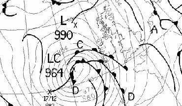 Met Office analysis chart for 0000 GMT on the 18th.
On the 3rd a rapidly eastward-moving depression brought a spell of heavy rain, with gusts over 50kn in exposed locations, to much of southern England by lunchtime, and heavy snow over the Peak District made driving difficult, while the rest of the UK again had a mixture of sunshine and showers. Later in the day another area of rain with gales approached western districts. Strong winds brought down trees in parts of southern England, and the Whitstable lifeboat capsized in rough seas. 2 people died in West Susses and Somerset. A combination of high tide and gale force winds, caused a breach in the sea defences of the west beach at Selsey, West Sussex, which resulted in local flooding. (Torquay 12C, Loch Glascarnoch 19mm, Swanage 4.6h). At Cardiff Weather Centre there was a pressure rise of 13.7mb in the period 0800 -1100 GMT and gusts over 70kn were recorded in places.
The 4th saw cloudy but mild conditions (13C was reported at many places at 0600GMT) in the south and southwesterly gales (and gusts over 70 kn) across Scotland, Northern Ireland and N England disrupting flights and ferries (Herne Bay 15C, Lusa 30mm, Aberdeen 2.9h). A severe thunderstorm hit the Western Isles in the early hours of 4th. On Lewis and Harris this caused the entire island to lose power from 0200hrs for two hours. The lightning display was noted as spectacular on Lewis and North Uist, and was one of the most severe thunderstorms to have hit the islands in recent years.
On the 5th and into the 6th there was some heavy rain over S Scotland and N England with falls of over 100mm in 24 hours in Cumbria leading to local flooding. It was again mild in southern Britain (cloudy on the 5th but sunnier on the 6th) in a SW airflow, but Scotland was colder with some snow falling on higher ground. Extremes on the 5th included Hawarden 15C, Windermere 114mm, Capel Curig 102mm and Jersey 7.3h, and on the 6th Gravesend 16.3C, Eastbourne 7.1h. Later on the 6th a cold front brought an end to the mild spell with sharp temperature falls occurring - 6degC falls in 1 hour at Gloucester and Coventry, and 4degC falls in 30mins at Birmingham and Manchester. Before the temperature fall, 16C was recorded at Kensington and 15.7C at the rooftop site of London Weather Centre - the highest January readings in London since 1841.
The 7th was a cooler day, with a band of rain moving eastwards across Ireland, then England and Wales, before becoming almost stationary over N England and S Scotland. Northern Scotland was cool and cloudy. (Guernsey 11C, St. Bees Head 22mm, Cromer 3.6h.) Once the rain passed skies cleared giving a widespread ground frost and icy roads, especially over parts of Scotland and Wales early on the 8th. The rain area moved generally SE during the 8th, introducing northerly winds over the British Isles. There were snow showers over a cool Scotland and down the east coast (Penzance 11C, Glascarnoch -5C, Leeming 14mm, Margate 6.1h).
Pressure rose on the 9th, which began with sub-zero temperatures in Scotland, N England and Northern Ireland, and icy roads in places. It remained cold with northerly winds, with snow showers over Scotland, Northern Ireland and down the east coast; Cornwall, however, was relatively mild (Penzance 9C, Glascarnoch -6C, Loftus 7mm, Torquay 8.0h). The 10th started cold everywhere; freezing fog all day in parts of Northern Ireland kept temperatures below freezing there in places all day, and there were further falls of snow in the north and down the east coast (many associated with the passing of troughs, including reports of 5cm in east Kent). (Tiree 8C, Belfast -2C max, Glasgow -8C min, Herne Bay 9mm, Newquay 7.7h.)
The 11th dawned with a widespread air frost over much of the British Isles and with freezing fog in places; in many parts of Ireland the fog lingered until early afternoon. There were further snow showers over Scotland and E England and it was another cold day away from extreme W coastal areas (Penzance 8C, Aviemore -8C, Folkestone 9mm, Torquay 7.8h); At Wilmington (Kent) the temperature did not rise above 3.1C. A southerly airstream bringing rain began spreading from the W over Ireland and W Scotland later in the day, turning to snow over Northern Ireland and mainland Scotland. By dawn on the 12th 9cm of snow had fallen over parts of Northern Ireland; as the front moved east snow fell over England and Wales before turning to rain as the temperature rose. The snow was heavy in parts of Wales, Scotland and N England. (Torquay 11C, Redesdale -7C min, Scarborough 1C max, Capel Curig 34mm, Edinburgh 5.1h).
After a cold start in places, rain spread eastwards across the British Isles on the 13th with gale force winds in W and N Scotland. Peak gusts included 60kn at Malin Head, and it was generally cloudy (Torquay 11C, Tulloch Bridge 13mm, Folkestone 1.6h). Following the clearance of the rain, skies cleared and the 14th dawned bright in most places with some snow showers on high ground in Scotland. Frontal rain spread rapidly across the British Isles from the W, followed by squally showers; peak gusts included 64kn at Malin Head and 61kn at Tiree. Snow closed some main roads in Scotland (Torquay 12C, Sella Ness 42mm, Eastbourne 7.2h).
After a warm night over England and blustery rain over S Scotland, the 15th saw rain spreading to most parts of England. There were wintry showers over high ground in Scotland giving moderate to heavy falls of snow, and it was windy in S England and Wales with gusts to 60kn. Flooding of roads occurred in Cumbria and S Wales. (Hawarden 13C, Aviemore -6C min, Aviemore -1C max, Eskdalemuir 45mm, Kinloss 1.4h.) In the 24 hours starting at 0900 GMT on the 15th between 50 and 70 mm fell over the mountains of N Wales, while on the island of Harris a severe SW gale in the morning caused widespread minor damage.
After heavy rain in S and SE England overnight, the 16th dawned with roads flooded in Worcestershire, S Wales, Herefordshire and Cumbria. Roads were also blocked by snow in Derbyshire and parts of the Scottish highlands. At Weston Coyney (near Stoke-on-Trent) the temperature fell from 8.8C in heavy rain at 0000GMT, to 1.1C at 0200 GMT in heavy snow. There were frequent heavy snow showers leading to blizzards in the Scottish Highlands, with gusts to 60kn leading to road closures and drifting of snow. Lying snow depths of about 30cm were reported at Aviemore. Snow also fell in Northern Ireland, Wales and the Pennines. Rain finally cleared much of SE England by midday, leading to a bright day over England and Wales with a few showers in the W. Six people were rescued from cars near Machynlleth in Powys. Melton Mowbray was cut off for most of the night 15/16th, and blocked storm drains flooded homes in Cranleigh, Surrey. The Leeds to Carlisle train was derailed by a landslide near Kirkby Stephen in Cumbria, and lightning strkes knocked out power in N Scotland and Western Isles. (Shoeburyness 11C, Aviemore 0C max, Aviemore -2C min, Coleshill 29mm, Oxford 6.7h.)
A southwesterly airstream brought some thundery showers to parts of the British Isles on the 17th, with rain in parts of S Scotland, and snow showers over higher ground in the N. (Southampton 10C, Moyola -1C, Loch Glascarnoch 24mm, Bristol 7.5h.) After largely clear overnight skies over England and Wales, the 18th dawned cold. Cloud and rain quickly spread from the W across the British Isles with gusts to 60kn in many places in the W. There was more flooding along River Severn in Herefordshire and Worcestershire. (St Marys 11C, Brize Norton -2C, Capel Curig 24.2mm, Norwich 4.2h.)
There was more heavy rain in mid and S Wales early on the 19th, spreading to much of W and S England during the day. There were blustery showers in N England and Scotland, although it was generally a mild day. (Hawarden 14C, Aviemore 1C, Eskdalemuir 22mm, Belfast, Newcastle 4.1h.) On the 20th a mild SW wind brought showers to Scotland, with more rain over England moving E. There was some flooding in Oxfordshire and Buckinghamshire, and the rain took all day to clear East Anglia and SE England. There were also reports of localised flooding in Towcester, Northamptonshire. The ground was heavily saturated throughout that county, particularly in clay areas, after the recent rains. (Torquay 13C, Aboyne -3C, Little Rissington 25mm, Newquay 6.9h.)
A weak ridge began building over S Britain from the W on the 21st. It was bright and sunny over much of Britain, with some freezing fog patches in SE England at first, and wintry showers over 300m in Scotland. In parts, the fog lingered all day. (Torquay 12C, Shoeburyness -4C, LerwicK 11mm, Fishguard 7.6h.) The 22nd began with a cold, icy, foggy start in England and E Wales. The fog again persisted all day in places, disrupting air traffic over much of SE England. An area of rain moved across Scotland later in the day. (Guernsey 11C, Marham 0C max, Shawbury -7C min, Lusa 24mm, Torquay 8.2h.)
The fog finally began to clear on the 23rd, which was a dull day with rain spreading from the W over most of the British Isles. (Torquay 12C, Larkhill -5C, Lusa 33mm, Herne Bay 2.5h.) Fog reformed around dawn again on the 24th in parts of S England; however this soon cleared as rain spread over Ireland from the W, and into S Scotland and England. Precipitation amounts were small in S England, with moderate/heavy rain and blustery winds in S Scotland and N England. (Torquay 12C, Pembrey Sands -1C, Castlederg 17mm, Stornoway 3.5h.) In Corsock (Kirkcudbrightshire) 33.2 mm fell in the 24 hours starting 0900 GMT on the 24th, with most of this falling between 1700 and 2300 GMT. During the evening of the 24th, moderate to heavy rain turned to snow and continued into the night over many parts of lowland Scotland, in particular Fife and the Lothians. For example, several cm accumulated in the Lochgelly areas of central Fife at about 150m asl, where roads were impassable.
The 25th began with a moderate falls of rain in parts of S England. Further bands of showery rain spread to most areas later in the day with falls of sleet and snow above about 300m in the N. It was mild in S England before the rain cleared with 13.5C at Buxton (Norfolk). (Gravesend 14C, Tain Range -3C, Eskdalemuir 43mm, Aberdeen 3.9h.)
There was rain over Ireland and S England during the morning of the 26th. Later in the day a line of heavier (in places thundery) rain crossed the S, with reports of ball lightning near Winchester around 1630 GMT and heavy hail in Reading during the passage of an active cold front. Gusts reached 60kn at Shoreham. It is also reported that something `just like a tornado' removed the roof from a house near Petersfield with trees and power lines being brought down, while sleet fell around Birmingham. (Littlehampton 12C, Redhill -1C, Bristol 16mm, Stornoway 6.8h.)
As the rain passed the sky cleared and the 27th saw a cold start in many parts of the N with subzero temperatures and icy roads. Further frontal rain spread across Ireland, and later across all of Britain, with snow on higher ground in Scotland. (Penzance 13C, Shap Fell -3C, Cromer 11mm, Bognor Regis 6.1h.)
The 28th saw early morning flooding in Staffordshire after overnight rain. A frontal band of rain moved southwestwards during the day over England and Wales, gradually decaying and introducing clearer and cold air from the N, as pressure rose under the growing influence of an anticyclone to the SW of the British Isles. There were a few showers in Scotland, while much of Ireland was rather cloudy with drizzle for much of the day. (Penzance 14C, Baltasound -2C, Capel Curig 43mm, Leeds 7.4h.)
The final three days of January were anticyconic in nature, and generally cloudy. On the 29th a band of light rain and drizzle crossed Britain from W to E, and there was little sunshine except in the Channel Islands. It was warmer in the W, and relatively cold in the E. (Penzance 12C, Benson -2C, Loch Glascarnoch 5mm, Jersey 5.0h.) The 30th began with patchy fog in places from central Scotland to southern England. Pressure continued to rise, reaching 1041.2 mb at Manston (Kent) by 2100 GMT. There was some sunshine in E Scotland, but elsewhere it was dull with light rain and drizzle in places. (Aberdeen 12C, Manston 1C, High Wycombe 5mm, Aberdeen 6.7.)
There was further patchy fog around dawn on the 31st, which was cloudy except in the Channel Islands and parts of E Scotland and extreme SE England. Pressure rose to 1042.9 mb at 1200 GMT around Southampton. (Tain Range 12C, Manston -2C, Colwyn Bay 4mm, Jersey 7.9h.)
The 2nd dawned clear over much of the British Isles, but with cloud over SE England< Northern Ireland and Scotland. The were icy patches on untreated roads, especially in the Midlands. Cloud pushed E to cover most of the country by lunchtime with light rain and drizzle over Scotland and Ireland. (Tain Range 12C, Shawbury -4C, South Uist 4mm, Herne Bay 5.8h.)
The 3rd was a mainly cloudy day. Rain over Scotland was accompanied by gale force winds along W and N coasts (including gusts to 55 kn at 1500 and 1800 GMT at Kirkwall). It was mild day generally. (Aberdeen 14C, Redhill -1C, Isle of Skye 31mm, Herne Bay 1.8h.)
A mild and cloudy night followed in most parts of the British Isles (overnight minima above 9C were widespread with 11.1C at Dyce), but in N Scotland temperatures began to fall in the early hours of the 4th as the cold front producing the rain moved S. The windy conditions moved S too: gusts of 74kn at Kirkwall and 56kn at Whitby were reported at 0900 GMT. Other gusts included 85kn at Fair Isle at 1745 GMT, 82kn at Kirkwall at 1200 GMT and a gust of 84kn at North Rona. The newspaper flight (a Cessna F406) en route to Stornoway had to turn back to Inverness after encountering a 145 knot headwind. In Yorkshire gusts of 71kn occurred at Leeming and Dishforth and 25km of the A1 road were closed due to 20 overturned lorries. In N and W Scotland 8000 homes were without power and flights and ferries were cancelled. As the front moved S the rain along it decreased and very little was observed in S England. (Hawarden 15C, Lerwick 4C max, Altnaharra 1C min, Altnaharra 16mm, Newcastle 6.7h.)
The winds died down a little overnight but there were still gales in N England and Scotland as the 5th dawned. There were wintry showers in a brisk NW wind during the day (of snow and/or hail) over Scotland and some northern districts. In the S temperatures fell after a S-moving cold front brought some rain showers. (Littlehampton 12C, Lerwick 3C max, Lerwick -1C min, Capel Curig 11mm, Leuchars 6.7h.)
On the 6th S-moving troughs brought snow and rain showers to Scotland, while over Ireland, Wales and S England fronts brought some rain. Driving conditions were difficult due to the snow in parts of Scotland, where a fresh wind made it feel very cold. (Torquay 12C, Baltasound 2C max, Lerwick -1C min, Capel Curig 23mm, Cromer and Lowestoft 4.4h.)
Skies cleared rapidly following the passage of the fronts in the S, and overnight temperatures fell to give a widespread frost over the Midlands, northern areas and Scotland. The 7th saw widespread snow showers over many parts of the British Isles, including S England, but more particularly over Scotland and coastal districts as far S as Norfolk and Lancashire. In Scotland some of the higher roads (e.g. A939 and A882) were blocked by snow, although much of the Central Lowlands, including Fife and Dundee areas, escaped the snow showers completely. Many parts of S England were very sunny. Dew points were low during the afternoon over parts of England, e.g. 1500 GMT reports from Leeming (temperature 3C, dewpoint -8C), Herstmonceux (4C, -9C) and Heathrow (5C, -7C). (Torquay 10C, Inverbervie -1C, Spadeadam -5C min, Lerwick 23mm, Hove 9.1h.)
Snow depths reported at 0600 GMT on the 8th included 2cm at Stornoway, 13cm at Dyce and 4cm at Hemsby and Orkney; Fair Isle schools were closed as a result. About 50 schools were also closed in NE Scotland, and many roads in the area were blocked by snow. There were further snow showers in N Scotland and down the NE coast to East Anglia during the day. Buxton (Norfolk) reported a minimum temperature of -6.2C and a grass minimum reading of -15.2C with 5cm of lying snow shortly after dawn. Up to 15cm of snow fell in parts of Wales as an active low crossed S Ireland, SW England and the Channel Islands towards France - it remained mild with rain to the SW of this low centre, but snow fall along its NE flank across S England. During the evening another swathe of snow fell over a wide area from the Thames Valley to Suffolk; the FA Trophy football match Stevenage - Cheltenham was abandoned due to snow at half-time. (Culdrose 11C, Glascarnoch -3C max, Aboyne -11C min, St Mary's Scilly 21mm, Newcastle 8.5h.)
The 9th dawned with a widespread air frost following the clearance of cloud after evening snowfall. Untreated roads in the Midlands, Wales and S England were reported to be treacherous during the morning rush hour, while in the N road closures included the A171 and A173 in Teeside, the A941 near Aberdeen, and the A9, A836 and A837 in Highland. All schools in Aberdeenshire and outer lying areas of Grampian Region were closed, as were those in other areas (e.g. Withernsea, E Yorkshire). One woman died in Broxburn, near Edinburgh, after she fell on icy pavements. Snow depths at 0600 GMT included 5cm at Kirkwall, 22cm at Kyle of Sutherland, 18cm at Aberdeen, 1cm at Heathrow. The snow depth at Fair Isle was considered impossible to measure, varying from less than 1cm to approx 2m. In Norfolk, very heavy snow showers were reported as reducing the visibility to less than 100m at times. Away from the snow showers in N Scotland and down the coasts the prevailing anticyclone gave quite a lot of sunshine, although the extreme SW was cooler than in recent days with snow showers in Plymouth and evening snow in other parts of the SW and S Wales. At Fair Isle the observer reported that at 1140GMT the wind suddenly increased from 26 kn (gusting 46 kn) to 010 deg 37 kn (gusting 57 kn); visibility fell to virtually zero in a heavy snow and hail shower, with blowing snow. At the same time there was a brilliant blue flash of lightning and crack of thunder. (Penzance 7C, Loch Glascarnoch -1C max, Saughall -8C min, Lerwick 15mm, Bognor Regis 9.0h.)
Snow depths reported at 0600 GMT on the 10th included 25cm at Aberdeen, 10cm at Stornoway and 3cm at Aberporth. Clear skies meant a widespread frost for most parts of the British Isles and most areas then had a sunny day. There was some snow over high ground in Scotland while cloud over Ireland and W Wales gave some light precipitation. Snow showers were reported down the E coast of England too. Belfast Harbour received 3 hours of snow grains during the afternoon, ahead of an approaching warm front. By the evening, snow still lay to a depth of 10 to 20cm on non-S facing slopes of the Mendips, above 200m, and there was a thin covering on the Cotswolds. (Guernsey 9C, Loch Glascarnoch 0C max, Saughall -8C min, Pembrey Sands 10mm, Teignmouth 9.2h.)
Cloud, and warmer temperatures, spread to the SE over Scotland, N England, Wales and Ireland by dawn on the 11th, although with lighter winds that recently SE England had a frosty start. By dawn rain was widespread over Scotland and the depth of lying snow at Aberdeen was down to 18cm. The warm front bringing the rain gradually spread E, turning the winds to the SW and giving some sleet, rain and drizzle. (Penzance 10C, Benson -8C, Altnaharra 14mm, Eastbourne and Jersey 8.7h.)
The 12th dawned with some rain (and occasional sleet) in SE England and a new frontal system over W Scotland giving further rain. In between these two there was a frosty start over England and Wales, although in Scotland the snow was continuing to thaw - the 0600GMT snowdepth at Aberdeen had decreased to 10cm. The rain in the SE soon died out, while that in the W moved slowly SE to reach parts of SE England by midnight. (St Mary's 11C, Shrewsbury and Birmingham -5C, Dundrennan 7mm, Stornoway 5.8h.)
The 13th began with light rain and drizzle over parts of Central and N England. Patchy fog and frost led to icy roads across parts Northern Ireland and Scotland, with visibility less than 200m in places. The rain spread W to Wales and moved gradually S, to give a sunny day in SE England and East Anglia. In parts of Central and S Scotland mist and fog lingered for much of the day. Air pressure rose to 1037 mb over Central and SE England later in the evening. (Penzance 12C, Aboyne -5C, Cardinham (Cornwall) 8mm, Eastbourne 9.2h.)
The weather on the 14th was dominated by the SE-ward passage of frontal systems over the British Isles, the effects of which still lingered over S counties of England at midnight. Clear skies before dawn led to a widespread frost over East Anglia, SE and Cent S England. Rain was heavy over Scotland early in the morning, before it turned showery there. (Penzance 11C, Farnborough -7C, Lusa (Skye) 17mm, Lerwick 4.8h.)
Rain cleared S England before dawn on the 15th, and clearing skies under a weak ridge led to slight frost in sheltered areas of S England. A warm front spread cloud and rain across Scotland by dawn, and then moved over N England. Temperatures rose to 10C over Scotland, before a following cold front brought more rain. Most of the British Isles remained cloudy during the day. (Poole 12C, Benson -3C, Lerwick 12mm, Jersey 7.2h.)
A NW airstream behind the cold front affected the whole of the British Isles by dawn on the 16th. Passing troughs brought heavy snow over Scotland with gales; gusts over 50 kn were recorded there. Scottish ferry services were disrupted due to the winds. One person died on the Cairngorm Mountains after spending the night in the open, and one person died on Ben Nevis as a result of weather conditions. Snow reports included drifts to 40cm at Fair Isle at 1415GMT (where at 1515GMT a wind gusting to 50kn with nil visibility at times in blowing snow was also reported), and a depth at 1800GMT of 10cm at Aviemore. Ireland, Wales and England had sunny intervals with a few showers, the latter mainly over Ireland and other W districts. (Southsea 11C, Baltasound 0C max, Lerwick -3C min, Lerwick 15mm, Hunstanton 8.6h.)
During the 17th a warm front pushed W, over Ireland in the morning and passing all but NE Scotland and extreme E districts of England by midnight. Rain (and sleet/snow on high ground) fell as the warm front passed. One person died near Drumochter after being lost overnight on the hills there. Snow depths at 0600GMT included 7cm at Kirkwall, 12cm at Aviemore, and 4cm at Aberdeen. (Guernsey 11C, Aviemore 1C max, Lybster -4C min, Lerwick 9mm, Norwich 5.6h.)
The front lingered over E districts of Britain early on the 18th, then moved E as further frontal rain spread E over Ireland and into Wales and W districts of Scotland and England by midnight. As the temperature rose any lying snow began to thaw rapidly, even over high ground in Scotland. (Poole 13C, Baltasound -4C, Warcop 12mm, Bognor Regis 4.2h.)
Cold fronts moved S on the 19th introducing a colder W airflow over all of the British Isles by midnight, but not before some mild conditions had been experienced in the southern half of England. There was some heavy rain in SW England, while later in the day snow showers were reported in parts of N and W Scotland. In Wells (Somerset) there was drizzle or rain for most of the day (with a break of only about an hour during the morning); in the 24 hours ending 1900GMT, the total fall was 32.3 mm. (Wittering 15C, Loch Glascarnoch 1C, Cardinham 37mm, Aberdeen 8.5h.)
Sunny spells in between bands of rain affected N areas, while England, Wales and S Ireland were mainly dry on the 20th (Guernsey, Torquay 13C, Stornoway 11mm, Eastbourne 8.7h.)
During the morning of the 21st an area of rain crossed S parts of Ireland, Wales and England; showers followed and these included reports of hail and thunder (with sleet observed at Chalfont St. Giles during the evening). Over Scotland and N parts of England showers of snow and hail were frequent, with gusts over 50kn being reported. There were moderate to heavy accumulations of snow in places, with roads in the Scottish borders reported to be treacherous in places by the end of the day. At Emley Moor (nr. Huddersfield) heavy snow showers with 50kn gusts produced blizzard conditions with level snow 10cm deep on many roads by midnight. (Poole 13C, Wick 2C max, Lerwick 0C min, Eskdalemuir 14mm, Leuchars 6.9h.)
By dawn on the 22nd there were numerous reports of snow-caused road closures in the Scottish borders, Cumbria, Pennines and N Scotland. The snow depth at Aviemore was 13cm at 0600GMT, with 3cm at Eskdalemuir. In Central Scotland some places had their first snowfall of the winter overnight, with about 1 to 5cm lying over the Forth Valley, around the Callander, Stirling and Falkirk area. At Wolverhampton snow lay over 1cm deep during the morning and there were reports of 7mm diameter hail there later in the day. Fresh, blustery N to NW winds brought frequent wintry showers to parts of the British Isles, mainly over Scotland but also as far S as S England. In between the showers there was plenty of sunshine; gusts over 30kn were widespread with gusts over 40kn across many parts of Scotland. (Torquay 11C, Tulloch Bridge 2C max, Drumalbin -1C min, Lerwick 13mm, Glasgow 9.6h.)
The winds gradually decreased overnight and became more westerly (and then southerly over Ireland) by dawn on the 23rd, as warm frontal cloud, rain and rising temperatures began affecting Ireland and W Wales. The 0600GMT snow depth at Aviemore was 12cm; in Moray and Aberdeenshire there were still some closed roads and driving was difficult in many areas of Scotland and N England due to icy conditions. By midday rain was falling in SW England, while it remained sunny in parts of East Anglia and SE England until late afternoon. There were reports of snow/sleet from Cent S England to S Scotland during the evening as the rain band advanced slowly E across the whole of England and wales, and S scotland by midnight. In the extreme SW England temperatures continued to rise (above 10C) during the evening. (St. Marys 10C, Tulloch Bridge 2C max, -3C min, Lough Fea 7mm, Folkestone 9.2h.)
The rain and sleet turned to drizzle over the S half of England by dawn on the 24th, with some light snow over N England and parts of East Anglia; clear skies over Scotland led to some icy roads there with temperatures being particularly low in the Highlands, although it was relatively mild over Ireland, SW England and S Wales by dawn. It remained cloudy over S Wales and SW England all day; cloud initially over NE England and East Anglia cleared slowly during the afternoon. Wales, much of Ireland, and England had a mainly dry except for some morning drizzle over S England, while increasing cloud brought rain and rising temperatures to N and Cent Scotland and N Ireland. Many parts of Ireland were cloudy and misty all day. (Guernsey 14C, Aviemore -9C, Isle of Man 19mm, Anglesey 9.3h.)
By dawn on the 25th it was cloudy over all the British Isles, with rain and drizzle over Scotland, N England and N Ireland. Parts of SE England and East Anglia had a frost under clear skies that existed for a while overnight. The 0600 GMT snow depth at Aviemore was 4 cm, and was falling rapidly. The rain remained for much of the day over almost all of the British Isles with some light rain and drizzle over Ireland, Scotland and N parts of England and Wales. With winds from the SW it was mild everywhere, especially in Scotland. (Kinloss 13C, Marham -4C, Lusa 18mm, Ross-on-Wye 4.6h.)
A band of rain associated with a SE-moving cold front crossed the British Isles on the 26th, although the rain was still falling in S England by midnight; a trough brought another area of rain and showers following the cold front, and although it was cloudy over much of England and Wales, parts of E Scotland were quite sunny. (Coltishall 13C, Redesdale 1C, Chivenor 14mm, Aberdeen 8.1h.)
The 27th was a showery day over the British Isles, once rain over S England had largely cleared by midday. Some of the showers were thundery over Ireland, W Scotland and parts of E Wales and N England, with falls of snow over high ground in Scotland; it was gusty, with gusts of 40kn, over Scotland. There were reports of a localised severe hailstorm in the Dublin area around 1630 GMT, while near Fife heavy snow in the evening brought the snow line down to 200m. (Torquay 12C, Topcliffe 0C, Lusa 26mm, Aberdeen 9.3h.)
Fresh to strong SW and W winds were the main feature of the 28th. Moderate to heavy rain over Scotland at first turned to sleet and snow later in the day. Ireland, Wales and England began dry, but rain moved E to affect most areas by midnight, with some thunder over NW extremities of Ireland. Gusts up to 60 kn were reported from NE England, and by the evening bridges in Cumbria and Newcastle, along with the Forth Road Bridge, were among those closed to high-sided vehicles. (Guernsey 13C, Aviemore 0C, Strathallan 39mm, Hastings 8.1h.)
2ndFollowing overnight rain and drizzle across almost all the British Isles, roads in the Welshpool (Powys) area were affected by flooding, while the River Afan was running high at Cwmavon. In Wells 32 mm of rain fell on the 1st and 2nd combined. It was a warm night in S England, Wales, the Midlands and Ireland with 1800 - 0600 GMT minima including Shawbury 10.0C, Heathrow 11.1C, Manston 10.2C, Yeovilton 11.3C and Cork 11.2C, although minima in Scotland were much lower. At Forest Hill (London), the minimum of 11.3C was higher than any March value for the past 25 years with the exception of 1981,1990 and 1998. It was a mainly cloudy day in most places, with widespread rain (heavy over Wales and W parts of England) and sleet and snow in addition over high ground in Scotland. It was very mild in S England, with maxima including 15.4C Reading University AWS site, 15.3C Maidenhead, 15.1C Heathrow, 14.8C Brize Norton; gusts of 30 to 40 kn were reported from SW England for much of the day (44 kn at Valley at 2100 GMT). (Aboyne -4C min, Capel Curig 47mm, Tiree 3.2h.)
The morning of the 3rd brought reports of a blockage along the A5087 Ulverston to Barrow coast road due to floodings, and of river flood alerts in S Wales and along the English-Welsh border. Heavy rain and blustery showers affected many areas of the British Isles at some time during the day, and it turned cooler in the W later as SW winds turned to a NW direction. Snow and sleet fell over high ground in N England and Scotland. (Guernsey 12C, Aboyne -3C, Sennybridge 29mm, Guernsey 8.4h.)
Following some heavy snowfalls on high ground in Scotland several roads there were blocked by the morning of the 4th, including the A939 between Cockbridge and Tomintoul, and between Ballater and Corgraff, and the A9 at Slochd. In addition, rescue teams were searching the Cairngorm and Ben Nevis mountains for walkers stranded in whiteout conditions. The SW wind over the SE corner of the UK turned northerly during the morning giving a cool day with some rain in the E and showers in the W, these being blustery in Scotland. Snow and sleet fell over high ground in Scotland, N England and N Wales. (Jersey 9C, Aviemore 0C, Newcastle 26mm, Lerwick 7.5h.)
Following clearing skies, the 5th began with icy roads in areas of S Wales, Northern Ireland and Scotland. Sleet and snow fell over the Pennines, E England and the Midlands at times during the day, where is remained fairly cloudy, while there were occasional rain showers over Ireland and Scotland with snow over high ground. (Torquay 9C, Buxton 2C max, Trawscoed -2C min, Scarborough 31mm, Lerwick 8.6h.)
A northerly airflow with embedded troughs continued to blow on the 6th. It was dull over much of the E half of England and Scotland, with snowfall in many E areas and over the highlands; falls were heavy at times in N England and over the Pennines, leading to the curtailment of sporting fixtures such as the FA Cup 6th round match at Barnsley. Flooding occurred in Pickering (N Yorkshire). Wintry showers were widepread, with hail in Jersey and Penzance, for example, although in some W areas, including much of Ireland, it was very sunny. On Dartmoor some heavy snow showers led to a covering of snow by the evening although on the Marlborough Downs snow fell without settling above 200m; in Stoke-on-Trent snow accumulated to a depth of 5cm at midday before thawing during the afternoon, while at Keyworth an accumulation of 3cm after two hours of heavy snow also subsequently melted rapidly. (Bognor Regis 10C, Birmingham 2C max, Biggar -5C min, Aultbea 15mm, Weymouth 9.2h.)
Clear skies over Ireland clouded over by mid-morning on the 7th and the remainder of the day was generally cloudy over the entire British Isles. Rain and drizzle was widespread over much of England and Wales, heavy at times in NE England. Ireland was mainly dry, while there were some wintry showers over Scotland. Snow led to the blocking of some roads in Yorkshire and NE England. (Penzance 11C, Buxton 2C max, Sennybridge -1C, Topcliffe 22mm, Penzance 10.0h.)
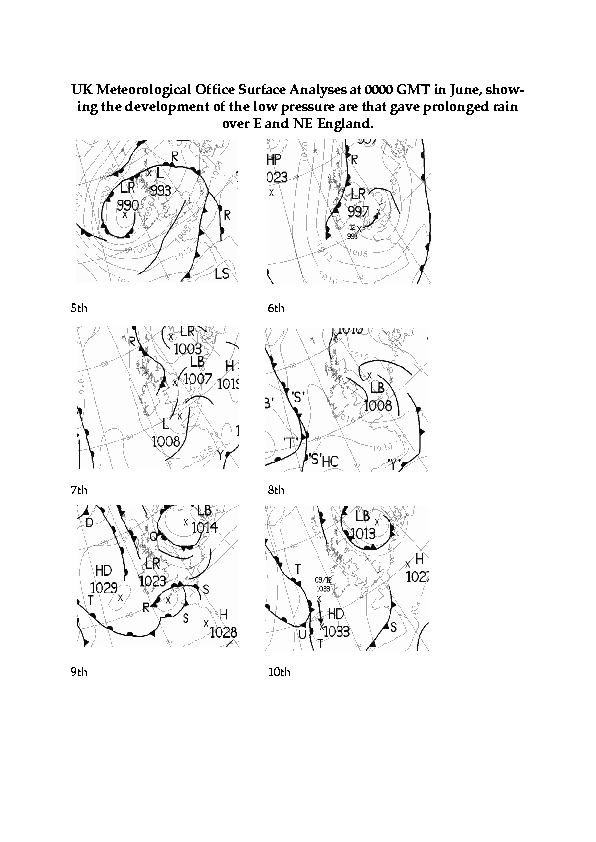
Little cloud over much of Scotland led to an early air frost in many places there by dawn on the 8th, followed by a day with sunny spells. England, Wales and Ireland were mainly cloudy, with rain and drizzle falling in the NE and E, under an easterly wind. There was also some light rain in SW England around midday, which moved slowly E in the evening. Snow caused the closures of the A6024 between Holmfirth and Glossop, and the A689 at Killhope (Durham) during the morning. (Herne Bay 9C, Saughall -6C, Guernsey 9mm, Tiree 7.6h.) Following heavy rain over a period of several days in North Yorkshire (e.g. 130mm in 5 days at Fylingdales Moor), a red flood alert continued in effect for the River Derwent in North Yorkshire between Stamford Bridge and Elvington; flooding was worst in Malton where the river was 3.5m above normal levels. The geographical extent can be seen in this figure, provided by the York Evening Press. The flooding by the river was the worst since 1931. Several roads in the area were impassable due to floodwaters, including the A64 at Malton, the A66 between South Bank and Grangetown (Cleveland) and the A1046 in Stockton (Cleveland).
The 9th was another generally cloudy day over England and Wales, with early-morning rain in the S clearing to the E by early afternoon. There was rain over E Scotland, NE England, the Midlands and East Anglia for most of the day, with sleet and snow over parts of NE England, the Pennines and the Midlands for a while; two hours of snowfall led to 5cm of lying snow in Sheffied by midday. W Scotland was sunny following a moderate frost in places, as was N Ireland, although S Ireland remained mainly cloudy. (Guernsey 11X, Buxton 2C max, Loch Glascarnoch -5C, Coningsby 12mm, Stornoway 9.0h.)
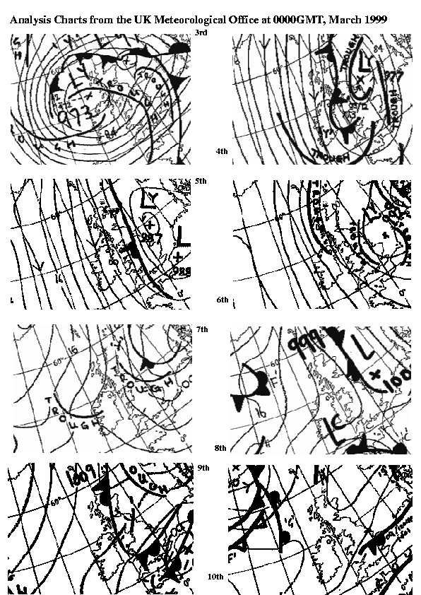
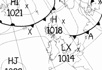
The persistent area of low pressure to the E of the British Isles that was the reason for the persistent rainfall during the previous week can be seen in these maps. At Marton (Cleveland) the rainfall total for the 10-day period 28 February to 9 March was 123.6mm, compared to the March average of just 26.7mm for 1991 to 1998.
Some roads in Cleveland and North Yorkshire remained severely flooded on the 10th while recent heavier rains further south (10mm in 12 hours at Lincoln and 34mm in 24 hours at Keyworth) led to flooding of the A610 in Nottinghamshire. Overnight snow on the A1 S of Grantham led to a slippery road surface (with 3cm of snow cover) that caused some minor accidents early in the day. In E parts of England there was further precipitation overnight 9/10th, although in other areas clearing skies for a while before dawn led to air frost, mist or fog in places. There was rain/sleet/snow in East Anglia during the morning; elsewhere it was mainly dry although in the evening rain spread from the W to parts of W Scotland. (Lee-on-Solent 11C, Bournemouth -5C, Watnall 19mm, Weymouth 9.7h.)
The 11th saw a frosty start in places, with icy conditions on some roads in Lancashire leading to early morning accidents. There were morning mist and fog patches in eastern England. Scotland and Ireland were generally cloudy with rain and showers, especially in the W, while England and Wales clouded over from the SW, the cloud being followed by light or moderate rain. (Jersey 13C, Leconfield -4C, Stornoway 21mm, Skegness 7.1h.)
Roads in North Yorkshire and Cleveland remained flooded by the morning of the 12th, and rain over England cleared in the S and Midlands to be followed there by mist and fog patches in places. Eastward moving fronts gave rain during the day to Scotland, N England and Northern Ireland, while rain (and rather misty conditions) pushed into S England around midday. This rain was heavy in places, e.g. in Yate (Gloucestershire) 22mm fell in 7 hours, leading to some local road flooding; there were also reports of thunder. At Forest Hill (London) the afternoon maximum of 15.7C was in contrast to values below 10C during the previous 8 days. (London 16C, Redhill 1C, South Uist Range 14mm, Colwyn Bay 9.3h.)
The wet and misty conditions (e.g. 23mm fell during the night at Wells) cleared from S England overnight, and here the 13th was a mild day. After a cold start with icy patches on some roads in N Scotland, rising temperatures led to melting of lying snow and an avalanche in the Ben Nevis range that killed one climber. It was very sunny in many areas. (Gravesend 15C, Loch Glascarnoch -4C, Exmouth 24mm, Colwyn Bay 10.2h.)
A ridge built over S parts of England on the 14th, where early morning clear skies led to a widespread ground frost before another mild afternoon developed. Cloud in Scotland and N England was accompanied by some light rain, while over the remainder of the British Isles there were sunny spells. (Poole 15C, Bournemouth -1C, Loch Glascarnoch 13mm, Bognor Regis 10.7h.)
Anticyclonic conditions persisted over southern areas on the 15th while in the N eastward-moving fronts brought spells of rain. Most of England and Wales had a warm and sunny day (after early ground frost in places), although parts of NE England and East Anglia were rather cloudy. Ireland was generally cloudy with rain in the N, and rain in Scotland was heavy at times. (London 16C, Bournemouth -2C, Lusa (Skye) 46mm, Bognor Regis 10.6h.) Pressure rose to around 1030 mb during the late morning in SE and cent S England.
The 16th was another mild day over S England, N Wales, the Midlands, East Anglia and S Ireland, although clear skies before dawn led to a ground frost in parts of Cent S England. N England, the Midlands and Wales had some overnight rain which persisted in some parts of N England and N Wales until early afternoon. Scotland and N parts of Ireland were generally cloudy, with rain and drizzle (especially in the W). (Hawarden 18C, Bournemouth -2C, Isle of Skye 34mm, Bognor Regis 10.5h.) Later in the evening it turned cloudy over most parts of the United Kingdom.
Following the clearance of cloud over most of England and Wales overnight, the 17th dawned with fog patches in parts of S England, Yorkshire, N Wales and Cheshire. Persistent cloud (with some light rain) over Scotland meant a warm night there - overnight minimum temperatures included 8.7C at Kirkwall, 9.1C at Stornoway and 10.2C at Dyce. At 0000 GMT pressure readings of 1032 mb were reported from Devon. Once the fog had cleared it was a warm and sunny day over S Wales, S England, East Anglia and the Midlands; in E Scotland temperatures rose to as high as 18.6C (at Dyce) once the cloud cleared, although it remained cloudy and therefore cooler in N England and S Scotland. At Bristol (Totterdown) the maximum temperature of 20.6C was reported to be the first reading above 20C in the area since 1965. In the south there were some large diurnal ranges, e.g. 15.9C (max 19.1C, min 3.2C) at Cirencester. (Shobden 21C, Leconfield 1C, Kirkwall 4mm, Penzance 10.8h.)
The 18th saw a slight drop in temperatures over England compared to recent days, the wind now blowing from a NW direction over the entire British Isles. Early morning fog patches in S England cleared to give some sunshine before cloud spread to much of the area by lunchtime. Over N parts of Ireland, N England and Scotland overnight light rain cleared by mid-morning to give sunny spells with a few showers, while the Midlands and much of Ireland was genarlly cloudy all day. (Bournemouth 16C, Shoreham 2C, Tulloch Bridge 9mm, Newcastle 10.5h.) Low relative humidity were recorded during the afternoon in S England, with 1500 GMT temperatures/dew points of (10.8C, -2.5C) at Brize Norton, (12.2C, -1.3C) at Boscombe Down and (12.8C, 0.0C) at Dunkeswell, for example.
The 19th was another day with fresh NW winds over the British Isles. Scotland had a mixture of sunshine and showers, while over England and Wales clear conditions overnight were followed by developing cloud during the late morning in most places. Ireland was mainly dry with sunny periods. (Great Malvern 14C, Yeovilton -1C, Lerwick 4mm, Scarborough 10.4h.)
The 20th dawned cloudy in most parts of the British Isles, with the exception of a relatively cloudfree area over SW and Cent S England at dawn. This area, too, rapidly clouded over and it then remained generally cloudy over the British Isles with the exception of the Channel Islands. There was light rain and drizzle over Scotland for most of the day, while an area of frontal rain pushed into Ireland, then to Wales and W England, during the afternoon and evening. At Cirencester the first 16 days of the month resulted in just 2 air frosts, but a ground frost occurred every morning from the 4th to 20th. (Poole 14C, Benson -2C, Kirkwall 11mm, Guernsey 8.7h.)
Pressure fell rapidly (falls of 5 to 7 mb in 3h were common) over most of the British Isles during the morning of the 21st as a depression tracked from W of the Outer Hebrides to the S North Sea; this was accompanied by an area of rain that subsequently cleared SE England around midday. As pressure started to rise, the wind veered from a southerly to a N or NW direction, and the remainder of the day saw blustery showers almost everywhere - these being of hail and snow in Orkney and Shetland. There was a report of a thunderstorm with hail near Canterbury around 1400 GMT. There were gales in exposed areas, with gusts to 50 kn in N areas. (Poole 14C, Loch Glascarnoch 2C, Capel Curig 23mm, Torquay 8.2h.)
The winds moderated overnight, and clear skies over S Scotland led to a widespread air frost there by dawn on the 22nd; much of the rest of the British Isles (except for SE Ireland and the Channel Islands) had a cloudy night with light rain and drizzle in E England. Another area of rain spread to most of Scotland and Ireland during the morning from the W, continuing for the remainder of the day over much of Scotland. During the afternoon light rain also crossed over England, although amounts were small there. (Bournemouth 12C, Biggar -2C, Kirkwall 12mm, Guernsey 8.9h.)
The 23rd was a cloudy day over much of the British Isles, with the exception of Cent S and SE England where there were sunny spells. There was light rain and drizzle over Scotland, N parts of Ireland and England before dawn, and over the N Midlands and parts of East Anglia shortly after dawn. In Caithness there were reports of 5cm of new lying snow, down to sea level in places. The rain largely cleared from England (except the extreme N) during early afternoon but continued over Scotland all day. (Poole 16C, Wick -1C, Buxton 16mm, Eastbourne 10.3h.)
Rain and drizzle overnight in Scotland moved slowly S and became less extensive during the 24th, affecting an area stretching from Cumbria to Cornwall by the late evening. Over Scotland and NW Ireland this clearance led to showers and sunny spells, while the remainder of the British isles was generally cloudy. (Marham 14C, Baltasound 3C, Sella Ness 18mm, Kinloss 9.5h.)
Temperatures fell under clear skies to give a slight frost over parts of N Ireland and Scotland by dawn on the 25th, although the night was cloudy over the rest of the British Isles with light rain from Scilly to the Isle of Man and NE England. Sunny spells and showers during the day over Scotland and Ireland contrasted with cloudy skies and pulses of rain over England and Wales, some of the rain being heavy in N England and the N Midlands. (Gravesend 15C, Castlederg -2C, Coleshill 10mm, Kinloss 10.3h.)
The 26th brought rain most places at some time suring the day, with fronts or troughs being analysed over most areas at sometime during the day. There was a frost at first in parts of E Scotland, then rain amounts were generally slight over most areas. The exception was SE England, the rain here falling from fronts associated with a NE-ward moving low centre. A brief but heavy hailstorm was reported in Birmingham in the late afternoon. (Poole 14C, Aboyne -3C, Redhill 12mm, Torquay 10.1h.)
Clearing skies overnight led to a ground frost in many places on the 27th from S England to N Scotland. The exception to this was the Midlands where a persistent trough gave light rain until mid-afternoon in places. S England had a very sunny day, as did parts of S and E Scotland. Other areas of the British Isles had a rather cloudy day, with frontal rain falling in N Scotland. (Bristol Weather Centre 15C, Aboyne -4C, Kirkwall 7mm, Torquay 12.2h.)
A weak ridge developed temporarily over the British Isles overnight, resulting in a cloudless night in many areas, with a widespread ground frost. By dawn on the 28th, however, frontal rain had reached most of Ireland from the W, and this pushed E to affect most of Scotland, Wales, NW England and SW England by midnight. Most of SE England and East Anglia had a very sunny day before the associated cloud arrived, however. (London 16C, Aboyne -6C, Tulloch Bridge 19mm, Hunstanton 11.0h.)
Extensive overnight cloud prevented air frosts for the night ending on the 29th, and most of the British Isles reported rain during the day. High minimum temperatures for the 12 hours ending 0600 GMT included Leeming 10.3C, Ringway 9.9C and St Mawgan 10.3C, although it was a mild night in most places. The rain was heavy in S Scotland and parts of SW England; the best of the sunshine was confined to Ireland, Scotland and NW England following the clearance of the rain. However, there were heavy showers in this clearance over Scotland, with thunder at Glenrothes at 1825 GMT, and torrential rain near Glasgow airport at 1600 GMT. (Glenanne, Jersey 16C, Redhill 4C, Eskdalemuir 51mm, Tiree 7.9h.)
It was mainly cloudy with light rain in S England, Wales, the Midlands and East Anglia on the 30th, after another mild night. The cloud pushed into N England during the day, but it remained mainly dry here. Scotland and Ireland had a mainly dry and sunny day, although there were a few rain showers in W Scotland. (Hawarden 17C, Lough Fea 4C, Tulloch Bridge 13mm, Edinburgh 11.1h.)
Cloud and light rain (associated with a N-moving warm front) pushed into N England before dawn on the 31st and during the day progressed into N Scotland. Ahead of the front there was a slight air frost in parts of Scotland, but in the Midlands and S England there was another mild night, with 12-hour minima at 0600 GMT including 9.7C at Shawbury, 9.9C at Heathrow and 9.5C at Hurn. As the cloud cleared behind the front temperatures rose to near 20C in many places (20.0C at Buxton, Norfolk; 19.8C at Romford, Essex). (London 20C, Aviemore -2C, Teignmouth 6mm, Clacton 10.4h.)
On the 2nd patchy bands of rain moved from the SW to NE across Ireland, Wales and England, becoming weaker as they moved N. In the Gloucester area there was a spectacular display of lightning around 0300 GMT from a line of thunderstorms that developed along a cold front. Cloud in Scotland cleared overnight to give a light frost in places by dawn, followed by warm conditions during the day except along the E coast where a cool sea kept temperatures low again. Away from the rain, England and Wales remained mainly cloudy. (Lusa 20C, Aboyne -1C, Prestatyn 14mm, Cromer 9.9h.)
There were fog patches by dawn on the 3rd in parts of S Scotland, N England, the Midlands and Cent S England with visibility down to 100m in places. Fog persisted in places nearly all day along the NE coast of England. During the day much of S England was cloudy with light rain and drizzle, while in N England and Scotland light rain gradually died out. (Leeds 19C, Tynemouth 7C max, Altnaharra -3C, Jersey 7mm, Lerwick 9.2h.)
The 4th was a cloudy day in most parts of the British Isles. Clearing skies overnight led to fairly widespread fog patches in Scotland and N England by dawn. Further bands of light rain and drizzle spread across much of the British Isles from the SW during the day. (Cleethorpes 19C, Aboyne 0C, Capel Curig 9mm, Cleethorpes, Lerwick and Scarborough 7.3h.)
The 5th saw a continuation of the recent mild, cloudy conditions over the British Isles with fronts and troughs bringing rain and drizzle to most areas. There was mist and fog in places around dawn, notably in SW Wales where visibility fell to 100m in places. (Chivenor 18C, Lerwick 6C, Lusa 15mm, Jersey 5.5h.)
There was rain (some heavy) overnight in Scotland, and light rain in S England the Midlands by dawn on the 6th. During the daytime it remained mainly cloudy across the British Isles with the two rain areas gradually clearing as the wind veered round to a W direction everywhere. (Herne Bay 19C, Aviemore 6C, Eskdalemuir 29mm, Leeds 8.0h.)
Pressure rose slowly during the 7th as a weak ridge became established over the British Isles. There were rain showers over Scotland and light rain and drizzle over Ireland. England and Wales were mainly cloudy but dry, with sunny intervals. (Boulmer 15C, Redesdale 4C, Loch Glascarnoch 9mm, Newcastle 9.0h.)
Skies cleared over parts of England and Wales overnight by dawn on the 8th leading to a touch of ground frost in places, although Scotland remained cloudy with light rain falling from a warm front. Light rain and drizzle that affected Ireland overnight moved E and many areas of England and Wales received some light precipitation during the day. (Aberdeen 20.2C, Benson 0C, Lowestoft 4mm, Folkestone 10.3h.)
A weak ridge of high pressure over the British Isles on the 9th resulted in a mainly dry day. The exception to this was Scotland, where there was light rain in the S overnight, and light rain and drizzle in places in the W and N by day. Ireland, Wales and England were mainly cloudy in the morning, but they became sunnier in the afternoon. (Great Malvern 20C, Fylingdales 7C, Stornoway 4mm, Shrewsbury 7.5h.)
A cold front brought a period of mainly light rain to most places across the British Isles on the 10th as it moved E, preced by thickening cloud and followed by clearer skies and showers in W districts. Fresh to strong winds over Scotland and Ireland were accompanied by gusts to 40 kn. (Skegness 16C, Benson 6C, Sella Ness 6mm, Fishguard 10.5h.)
Mainly clear skies overnight led to lower temperatures than of late by dawn on the 11th over much of the British Isles. However, thickening cloud over Scotland and Ireland was followed by rain by lunchtime in W districts there; the rain continued to move SE to affect most of England and by midnight. (Poole 16C, Altnaharra 1C, Tiree 11mm, Isle of Wight 12.0h.)
The 12th was dominated by a showery NW airstream with embedded troughs, giving heavy showers of rain and hail, and occasional thunder, to most parts of the British Isles. The thunder was mainly restricted to N England (especially Yorkshire), the East Midlands and East Anglia, and SE England. There were gales in exposed areas in the W, and gusts to 50kn in S Ireland and SW England. At 1500 GMT there was a report of a funnel cloud near the Humber Bridge. (Herne Bay 15C, Lerwick 6C max, Wick 1C min, Capel Curig 59mm, Bognor Regis 9.9h.)
The 13th did not feel like a spring day over most of the British Isles. A depression crossing from N of Ireland to East Anglia was accompanied by gales on its S flank, and snow and hail showers. In Fife snow made driving difficult during the morning rush-hour. These wintry showers (quite blustery with gusts to 50 kn in places) persisted after the passage of the low, and were felt over most parts of the British Isles - although in SW England and S Ireland precipitation was mostly of rain. In Chelmsford hail the size of marbles fell around 1050 GMT, while cricket at Durham was cancelled due to a snow-covered ground. Later in the evening, skies cleared everywhere. (Penzance 13C, Loch Glascarnoch 2C max, Lerwick -1C min, Buxton 13mm, Torquay 11.2h.)
The 14th dawned with 6cm of lying snow at Dublin at 0600 GMT (which had mostly melted by 1300 GMT), and a widespread air frost following clear skies overnight. Morning cloud in SW England and S Wales was accompanied by heavy snow for a while in places and wintry showers were widespread during the rest of the day in W districts and over Ireland. Thunder was reported in NE England, although many E districts remained sunny for most of the day. At Weston Coyney (Staffs.) the minimum of -4.2C was the lowest in April since -4.2C on 11 April 1978. In one hour from 2230 GMT 3.5cm of snow fell in 1 hour at Bradninch (Devon), while at Wells (Somerset) snow fell from about 0700 GMT to 1400 GMT. A waterspout was observed from 1600 to 1605 GMT outside Rocquaine Bay (approx. 1 mile SW of Pleinmont Point) off Guernsey; it was moving S ahead of a heavy shower of soft hail. At Pentlow (Essex) a tornado lifted a dog out of its kennel and destroyed a few greenhouses. (Torquay 11C, Loch Glascarnoch 3C max, Redesdale -7C min, Altnaharra 19mm, Aberdeen 12.2h.)
The 15th dawned with some roads closed in Wales (A4107, A965, M4) and Scotland (A93). 0600 GMT snowdepths included 2cm at Eskdalemuir, while on the Mendips snow lay approximately 10cm deep during the morning. Clear skies led to a widespread frost with minima including -4.2C at Buxton (Norfolk). Early rain and drizzle over Central and S Scotland and N England largely cleared by early afternoon, but scattered showers continued almost everywhere for most of the day. These showers were wintry (of snow or hail) as far S as Hampshire with reports of 5cm of snow on the Isle of Wight. A funnel cloud was observed near Jersey at around 0700 GMT. (Northolt 12C, Sella Ness 5C max, Aviemore 20mm, Penzance 11.7h.)
Snowfall overnight led to blocked roads in Cumbria (A592 Kirkstone Pass) and West Yorkshire (M62, A6024) by dawn on the 16th, while in S England light winds allowed patchy, but thick, fog to form. By the afternoon there was a covering of 10-15 cm of snow on the top of Holme Moss (Yorks). Heavy thundery rain fell in Lincolnshire during the afternoon, and there was thunder in the Midlands. Northern England experienced rain or snow for much of the day from a persistent trough, while snow showers were fell over the higher ground in Scotland. Elsewhere, it was mainly dry but with scattered (often heavy) showers especially in SW Ireland, S Wales and SW England later in the day. (Poole 13C, Bingley 2C max, Tulloch Bridge -6C min, Waddington 28mm, Tiree 12.5h.)
Clearing skies overnight led to a frost in places by dawn on the 17th; the exception to this was N England where a slow-moving trough continued to give some rain. In S England there were fog patches by dawn. This wet, cloudy area persisted all day, spreading to the Midlands, North Wales (for a while) and East Anglia. Many areas had a day with sunny spells (although some heavy, at times thundery, showers occurred in places) although low pressure over Scotland resulted in some light rain with snow on higher ground. Near Dunstable, a glider was hit and downed by reported ball lightning which flew out from cumulonimbus - the glider was under a clear sky at the time - the two pilots managed to bale out with only minor injuries. (Bognor Regis 14C, Buxton (Derbyshire) 5C max, Altnaharra -4C min, Coningsby 30mm, Aspatria 11.5h.)
The 18th saw a continuation of the general weather pattern, with a slack pressure gradient and troughs, this time over W districts and in the E. Further rain in East Anglia overnight led to the flooding of the A134 by daybreak in the Bury St. Edmunds area, and along the A11 near Newmarket. After early fog patches, in S England and the Midlands, cloud soon developed in most areas and there were further heavy showers with snow, rain and hail. A thunderstorm with snow and heavy hail near Southend around 1800 GMT resulted in about 7 to 10cm of snow and ice on the A127 road, and several accidents. The best of the sunshine was over Ireland and in W districts after the clearance of early cloud. Following recent falls some small patches of snow were still visible on the hills to the W and NW of Newport and Cwmbran (above about 350m amsl) in S Wales. (Penzance 13C, Baltasound 5C max, Aboyne -4C min, Margate 21mm, Tiree 12.7h.)
Skies cleared everywhere by dawn on the 19th (leading to a frost in places), except in East Anglia and Kent, and in parts of E Scotland where there was some light rain. Cloud soon developed in most places with the SE wind hearlding the approach of a frontal system from the SW. The system brought rain to SW England and S Ireland by midday, and the rain pushed into most of S Ireland, S Wales, Cent S England by midnight. There were showers of rain or snow of Cent and N Scotland, but the remainder of the British Isles was largely dry. (Colwyn Bay 13C, Castlederg -5C, Manston 21mm, Tiree 13.1h.)
The rain continued to spread NE during the night and by dawn on the 20th covered all but N and Cent Scotland. By midnight the rain had reached Orkney, and was particularly heavy for a while in Cornwall and Devon. The rain was followed by blustery showers over Ireland in the SE airflow. Pressure fell to 969 mb by 2100 GMT, and gusts over 40kn were widespread in N Ireland and S Scotland; 58kn gusts were reported from Malin Head at 1200 GMT. (St Angelo (N Ireland) 14C, Altnaharra -3C, Dundrennan 40mm, Lerwick 11.8h.)
The rain and showers diminished over England and Wales overnight with rainfall being largely confined to Scotland by dawn on the 21st. An advancing low resulted in still-falling pressure during the morning and early afternoon over most of the British Isles, with 968 mb being reported at Shannon at 0300 GMT. Further bands of blustery rain and showers affected the British Isles during the day with gusts to 40 kn being widespread as the wind gradually veered to the SW. The evening footbal match at Swansea City was postponed due to a waterlogged pitch. (Gravesend 16C, Loch Glascarnoch 3C, Capel Curig 32mm, Margate 9.6h.)
Rain over Scotland continued to move N during the night, to be followed by showers over the British Isles on the 22nd. These showers were often heavy and blustery, with hail and thunder in places. Shortly before midnight, another area of rain began pushing into Cornwall from the S. According to a report in the Dublin Evening Herald, a tornado in Ballygawley (Co. Sligo) around 1410 GMT caused several thousands of pounds worth of damage with trees being uprooted and objects being carried for several hundred metres. (Great Malvern 16C, Spadeadam 6C, Shap Fell 24mm, Guernsey 10.8h.)
A slow-moving area of heavy rain over SW England during the night moved into N England by the end of the 23rd, with falls being large in the SW. Wells reported 24.3mm of rainfall and there was local flooding of roads, eg. the A3102 in Wiltshire. There was a ground frost in some northern areas before dawn, but cloud and rain soon spread to W Scotland. It remained sunny, however, in between these two rain areas, with rain showers over Ireland. (Coltishall 16C, Aviemore 0C, Exmouth 27mm, Isle of Man 12.1h.)
The 24th was a cloudy day over much of Scotland, S and E England and the Midlands. Rain in W Scotland largely cleared by midday, and overnight rain in NE England gave way to showers there; there were further showers in E districts of England (some heavy and with thunder, e.g. at Chedburgh). W England, Wales and Ireland had sunny spells. (London 17C, Aboyne 0C, Chedburgh 33mm, Tenby 11.8h.)
Frontal rain pushed into S Ireland, SW England and S Wales by dawn on the 25th. This slow-moving area of, at times heavy, rain continued to push NE during the day, extending to SE England, the Midlands and Wales by the evening. Parts of East Anglia had a sunny day until the frontal cloud arrived, while it remained rather cloudy in Scotland. Mist and fog formed over parts of NE England and SE Scotland by midnight. (Aspatria 18C, Shap Fell 2C, Cardinham 50mm, Clacton 11.1h.)
With an easterly wind off the North Sea, early morning fog on the 26th was dense in places in NE England and SE Scotland; although it cleared from most places, it did persist for most of the day in parts of NE England, resulting in some low maxima (e.g. 8C maximum at Loftus). Scotland and N Ireland has a mainly dry and sunny day, but rain over S Ireland, Wales, the Midlands and W England was slow to move, being heavy in places with thunderstorms reported. Later in the day rain and drizzle also fell in East Anglia. (Herstmonceux 19C, Loch Glascarnoch 2C, Barbourne 41mm, Stornoway 11.6h.)
The 27th was much drier than in previous days, due to an anticyclone centred just W of Scotland; pressure rose to 1035.3 mb at 2100 GMT at Malin Head. Mist and fog over NE England and E Scotland persisted in places until about midday; most other areas were clear overnight, although early cloud in S England, the Midlands and Wales gradually disappeared during the day. Once early fog and cloud had gone, it was mainly dry and sunny in most places, and quite warm in parts of NW England and W Scotland (21.8C at Kyle of Sutherland and 21.5C at Windermere) where the E wind was light. A notable exception was the Outer Hebrides, where fog lingered all day in places, while cloud remained all day in the Northern Isles. At Cirencester, a heavy thunderstorm from 1529 GMT to 1552 GMT resulted in 11.7mm of rain, with half the carriageway of the ring road under water on the W side of the town. (Dalmally 22C, Tulloch Bridge 1C, Cirencester 12mm, Tiree 13.9h.)
Most of the British Isles has a warm and sunny day on the 28th. The exceptions to this were N and central Scotland where there was extensive low cloud with some light rain, and some coastal areas of E and NE England where early morning cloud did not clear in the E wind and temperatures remained low. Later in the evening this low cloud started to push W over East Anglia and SE England. 22.6C was reported from Windermere (unofficial site) and 21C from Llanbedr (official site), while in Ireland 19.8C was measured at Cork. (Tynemouth 8C max, Leeming 2C min, Wick 2mm, Manchester 14.2h.)
It was again largely warm and sunny over much S Ireland, Wales and the S half of England on the 29th once early morning low cloud and drizzle in E and Cent S England had dispersed, with 20.6C at Shannon. In N and W Scotland it was cloudy with some light rain, while N England, N Ireland and S Scotland had sunny spells with warm conditions in SE Scotland. (Charterhall (Borders) 22C, Eskdalemuir 3C, Kirkwall 4mm, Newquay 13.6h.)
After a clear night with ground frost in places, Wales, S and central England had a warm and sunny day on the 30th away from the coasts where an E wind kept temperatures lower. There was some cloud over N areas and over much of Ireland; where this persisted all day, as well as along the E coast, temperatures remained low. The unofficial station at Bristol Totterdown reported a maximum of 23.1C. (Northolt 22C, Benson -0C, South Uist 2mm, Bognor Regis 13.9h.)
Early cloud over E and S England was slow to clear in the E/NE wind on the 2nd and persisted all day in parts of NE England. Fog in SW and Cent S England soon cleared and it was eventually warm and sunny over most of Wales and the S half of England. There were sunny intervals in Ireland after early fog cleared, while Scotland remained mainly cloudy with light rain in the NW and Northern Isles. (Bristol 22C, Redesdale -0C, South Uist 3mm, Jersey 13.2h.)
The 3rd began with cloud over much of Scotland and fog in parts of NE and Cent S England. This all soon cleared except in NW Scotland where there was some light rain during the day; Ireland had a day of sunny intervals and some cloud, while much of England and Wales was warm and sunny. As far N as Windermere 23.7C was recorded. However, cloud developed over S England and Channel Islands during the afternoon. (Saunton Sands 25C, Redesdale 2C, Stornoway 1mm, Anglesey 13.9h.)
The 4th was another mainly dry day, except in parts of N Ireland and W Scotland where some rain fell. S England, and parts of the Midlands and Wales were generally cloudy, with mainly medium-to high-level cloud, and some cloud persisted along the E coast of England. Scotland saw quite a range of temperatures during the day between the W and the Northern Isles. (Lusa (Skye) 23C, Fair Isle 8C max, Altnaharra 1C min, Ballykelly 4mm, Isle of Man 13.3h.)
Cloud developed overnight and into the morning of the 5th over most areas of the British Isles. Light rain began falling in parts of S England around midday, and pushed slowly N to affect most of England (except the extreme N), Wales and S Ireland by midnight. Scotland remained generally dry, with sunny intervals. (Prestatyn 20C, Aviemore 2C, Benson 3mm, Aberdeen 9.0h.)
Cloud and rain over England, Wales and S Ireland continued to push N and by dawn on the 6th had reached S Scotland and Northern Ireland. There were reports of sand falling in the rain from Wigan, Rutland, the Midlands, while visibility fell below 1000m for a while in places due to the rain and low cloud. The rain reached N Scotland by nightfall, although the Northern Isles remained mainly dry, and the associated began clearing from S England, Wales, the Midlands and S Ireland during mid-afternoon to give a fine end to the day here. However, another area of rain reached Cornwall shortly before midnight. (Prestatyn 20C, Loch Glascarnoch 7C, Newcastle 12mm, Lerwick 13.9h.)
Rain spread to much of S Ireland, SW England and S Wales by dawn on the 7th, and by late morning there was heavy rain in parts of NW England and the N Midlands. Overnight cloud brought light rain and drizzle to parts of Scotland, and there was some fog along the E coast here. The N-moving rain over England reached S Scotland by late evening, and it turned drier with scattered showers (some thundery) in S Ireland, S Wales and SW England by this time. There were also evening reports of thunder in SE England associated with a large thundery outbreak moving N over W France and Benelux. At Pitsford Hall (Northamptonshire) 15.5mm of rain fell during the 24 hours beginning 0900 GMT, with a peak intensity of 22.4mm per hour shortly after 1400 GMT. (Hunstanton 21C, Redhill 3C, Manchester 18mm, Lerwick 13.9h.)
The rain area over the Midlands and N England continued to move slowly N during the night; later during the morning of the 8th more rain began to affect S Ireland and SW England, with some gusts to 30-40 kn in exposed areas of the SW. (Hemsby 18C, Aonach Mor 3C.)
The 9th was a cloudy day over much of the British Isles, with slow-moving fronts and troughs giving further spells of rain. Gusts in W districts reached 50 kn at times as S winds blew around a low centred to the W of S Ireland. (Gravesend 22C, Aviemore 4C, Capel Curig 18mm, Herne Bay 11.0h.)
S winds continued to affect the British Isles on the 10th, with bands of rain moving generally to the E. Some of the rain was heavy, with thunder reported from places in N and E England, Northern Ireland and parts of Scotland (where temporary power cuts were reported in Sutherland). In Wigan a thunderstorm around 1200 GMT gave hail up to 25mm causing small dents in cars in the S of the town. (Lowestoft 20C, Lerwick 6C, St Athan 19mm, Eastbourne 11.5h.)
Further bands of rain and showers affected the British Isles on the 11th, with some of the heavier rain falling in N England and S Scotland. S winds persisted, as the low remained anchored to the W of S Ireland. Thundery activity occurred over parts of E and N Ireland and E England during the afternoon and evening. (Gravesend 19C, Loch Glascarnoch 3C, Eskdalemuir 27mm, Southend 13.3h.)
The rain over S Scotland and N England diminished during the morning of the 12th, although scattered showery outbreaks (with some heavy rain) continued in many other parts of the British Isles, with more persistent rain in the extreme N of Scotland. Thundery activity during the late afternoon and early evening affected E Ireland, parts of Ireland and central Scotland. (Herne Bay 18C, Lerwick 6C, Eskdalemuir 27mm, Hayling Island 11.5h.)
Many areas of the British Isles were affected by spells of rain or showers during the 13th, with the winds turning to the N during the afternoon over Ireland as a low centre crossed the country. Some of the showers were heavy and thundery over parts of Ireland and N England. At Drumburgh (Cumbria) hail 1cm in diameter fell during a heavy thunderstorm in mid-afternoon (the observer there reports "our cottage was actually struck by one isolated stroke, no damage but we were shaken"), and there were reports of a funnel cloud near Banbridge (Co. Down) in the evening. (Heathrow 19C, Baltasound 5C, Drumburgh 36mm, Isle of Wight 11.3h.)
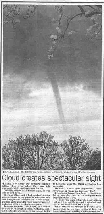
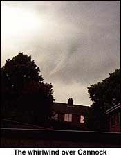
A slow-moving area of low pressure centred over England and Wales on the 14th brought spells of rain to these countries; the rain was in places heavy and thundery, and accompanied by hail. Scotland remainded mainly dry, while there were a few showers in the N airflow over Ireland. A small funnel cloud was observed over NE Hertfordshire (near Barkway) at 1443-1448 GMT. The funnel cloud was estimated to be no more that 600 feet high, with a maximum diameter of 100 feet. There were other reports of funnel clouds being widely seen, including at Corby (Northamptonshire) - see NEWSPAPER ARTICLE WITH PHOTO. Lightning knocked out a signal box on the railway between Reading and Basingstoke. The Met Office surface analyses for 0000 GMT on the 14th and 15th show a slack area of low pressure over the British Isles. (London Weather Centre 19C, Dunkeswell 30mm, Guernsey 12.9h.)
As the depression declined and moved over the North Sea, winds became generally lighter and from the N on the 15th. Much of S and SE England remained rather cloudy (and there was some rain in the extreme SE), as was N Scotland where a cold front brought some light rain. In between these two cloudy areas is was mainly sunny, although it soon turned cloudy over much of Ireland. (Saunton Sands 19C, Loch Glascarnoch 2C, Kenley 6mm, Valley 14.6h.)
The S-moving cold front meant that the 16th was generally cloudy with rain in places. Any rain was, however, genrally light as pressure was high over the entire British Isles (Valentia reported 1026.3 mb at 0900 GMT). Some coastal areas remained almost cloudfree and had the best of the sunshine. (Plymouth 17C, Lerwick 3C, Wittering and Hemsby 1.3mm, Ronaldsway 14.5h.)
The main feature of the weather in the S half of England on the 17th was the increasing windspeed (with gusts to 30 kn) of the E flow during the afternoon. This, and increasing cloud cover, heralded the N movement of a low system over France. Clear skies over parts of Scotland led to an ground frost in places at first, followed by a sunny day. N England and Northern Ireland began cloudy with isolated light rain which largely faded out. On Fair Isle the maximum temperature was just 9.4C, despite 15.7h of sunshine which made it (provisionally) the sunniest place in Britain. (Lee-on-Solent 17C, Wick 0C, Shoeburyness 0.8mm.)
Clear skies over N Scotland resulted in some air frost reports by dawn on the 18th. Thereafter, most of Scotland, Northern Ireland and N England had a sunny day. Low humidity readings in parts of Cent Scotland during the afternoon included reports below 30 per cent (possibly orographically-related in the SE flow), while 32 per cent was reported from Leeming at 1500 GMT (temperature 16.6C, dewpoint -0.2C). It warm afternoon in parts of W Scotland, with 22.7C at the unofficial site at Kyle of Sutherland. Over S England and Wales a slow-moving band of cloud associated with the low over France brought a cloudy day with light precipitation; in coastal counties of S England falls were occasionally heavy in nature. S Ireland turned cloudy but remained mainly dry. (Jersey 20C, Aboyne -2C, Isle of Wight 13mm, Kinloss 15.6h.)
Most parts of S Ireland, Wales, and England S of the Pennines, had a cloudy night with fog forming by dawn on the 19th in parts of the Thames Valley. Other areas had a clear night with a ground frost in parts of Scotland. Scotland then had a sunny day while further s cloud moved N over much of England, Wales and Ireland. After a wam and quite humid day, thunderstorms occurred over SE, Cent S England during the early evening, moving to the S Midlands later in the evening. Some thunderstorms were heavy in the SE with hail in places (1cm in diameter at Maidenhead where 20mm fell in 20 minutes, the temperature fell 7C during the early evening storm, pressure rose 2mbar and roads were temporarily flooded). The NOAA12 channel 4 thermal image at 1637 GMT (courtesy of Bernard Burton) shows what appears to be a mesoscale convective system of storms during this event. At Crowthorne 26.3mm fell between 1630 GMT and 1745 GMT. In Hampshire, golfball-size hail fell at Easton and Itchen Stoke, and the hail was still lying 15 hours after the storm. Conservatory roofs, glasshouses and guttering were damaged by the storm and gardens and crops were devastated there, and several minor roads were flooded. There were also reports of large hail on the Isle of Wight. (London Weather Centre 24C max, Redhill 22mm, Lerwick 16.0h.)
The thunderstorms had almost died out by 0000 GMT on the 20th over the Midlands, leaving patchy cloud and fog patches in SW and Cent S England and along the NE coast of England by dawn. Skies were clear over many parts of Scotland by leading to some ground frost by dawn; during the day advancing cloud from the W there and over parts of Ireland was followed by light frontal rain later in the day. S Scotland, England, Wales and S Ireland had a warm day (except for a few coastal locations in NE England where fog lingered), although developing cumulonimbus clouds produced a few rain showers in S England during late afternoon. 23C was reported at Leeds Weather Centre, with 23.8 at the C.O.L. station at Langtoft. (Aboyne 0C min, Birmingham 15mm, Lerwick 15.2h.)
Overnight frontal rain over Ireland during the night had reached most of Scotland and W Wales by dawn on the 21st, then continued moving E to clear the British Isles by late evening. Ahead of the rain (which was heavy in parts of Scotland) it was sunny in East Anglia and the extreme SE England; the rain was followed by showers (hail was reported at Stornoway) and sunny spells in the W. (Margate 22C, Aultbea 4C, Lusa (Skye) 28mm, Herne Bay 11.7h.)
A westerly airstream brought showers to Scotland, Ireland and W districts of England on the 22nd. Some of these showers were heavy with hail in Scotland and gusts to 40kn occurred widely in the N and W. Malin Head reported a gust to 51kn at 0600 GMT. During the evening an area of rain and drizzle began to affect W and S areas of Scotland. (Poole 20C, Aviemore 1C, Loch Glascarnoch 22mm, Aberdeen 14.0h.)
Cloud formed extensively over the British Isles overnight as the area of precipitation over Scotland moved slowly S to affect most of Ireland by dawn on the 23rd, and N England later in the day. Most of England and Wales remained dry but cloudy with gusts to 40 kn being widespread over Scotland and N England. Behind the rain area, which persisted over S Scotland and Ireland, N Scotland had a day of sunshine and showers. (Gravesend 20C, Lybster 5C, Sella Ness 7mm, Stornoway 11.0h.)
The rain area over S Scotland, N England and Northern Ireland moved slowly S during the 24th, weakening steadily and clearing SE England by late evening. In its wake skies cleared and there was sunshine and showers, some thundery in N England. Gusts to 30kn were again quite widespread in parts of N England and S Scotland. What was described, on local TV and press, as a mini tornado occured at North Ferriby (near the Humber Bridge) in the evening. Although damage did occur, i.e. branches broken off trees, house windows and car windows smashed by falling trees and branches, it was very localised. (Coltishall 19C, Loch Glascarnoch 4C, Keswick 15mm, Edinburgh 12.9h.)
It was showery overnight (with some hail reported) in Norther Ireland and N and W Scotland; elsewhere the 25th dawned dry with nearly clear skies leading to a ground frost in places in S England. It remained mainly dry in most places, except for occasional showers in parts of N Scotland, until an area of rain began moving E across Ireland around midday, reaching W Scotland and NW Wales by late evening. (Gravesend 19C, Benson 3C, Buxton 8mm, Folkestone 13.3h.)
Areas of frontal rain crossed the British Isles on the 26th although amounts in S England were, at most, light. Clear skies ahead of the rain brought a few low minima in the S, and a mainly sunny day along SE coastal areas. (Gravesend 23C, Bournemouth 3C, Isle of Skye 16.2mm, Clacton 14.6h.)
Cloud and rain persisted over much of scotland and Northern Ireland during the 27th. Further S, a ridge brought warm and sunny conditions, until thunderstorms began moving NE across SW England, reaching Lincolnshire and Norfolk by midnight. In Bradninch (Devon) a thunderstorm began at 1800 GMT; the observer noted at least 40 cloud-to-ground strikes with a roof and tree struck; 18.8mm fell from 1800 to 2115 GMT. A thunderstorm at Keyworth (Notts.) from 2245 GMT to 0015 GMT on the 28th resulted from a line of spectacular storm cells slowly moving N across South Nottinghamshire with frequent long lasting cloud to cloud and cloud to ground strikes; a brief period of intense rain followed as the storm gradually flickered away to the north leaving a chorus of car and house alarms. Many observers commented upon the intensity of the lightning displays, while at Chalfont St. Giles a dust deposit was left by the rain. In the Solihull area damage reports included: 30000 households without power, lightning set fire to vent pipes connected to fuel tanks at a petrol station at Cradley Heath, and lightning blew a hole in the roof of a new Midland Metro tram and set it alight. (Heathrow 26C, Baltasund 5C, Falmouth 11.2mm, Hastings 15.1h.)
The thundery area moved into NW and NE England in the early hours of the 28th, which began with heavy rain in N Scotland and in Northern Ireland. Rain over Ireland and Scotland persisted for much of the day, while England and Wales were mainly dry except for lingering rain in some N areas of England. (Jersey 23C, Lerwick 6C, Kirkwall 38mm, Cromer 12.8h.)
Rain continued to fall over many parts of Scotland until early afternoon on the 29th, while Ireland has a mainly cloudy day. England and Wales began dry and sunny and became quite warm in places. An area of thundery activity (accompanied by hail in places) moved into SW England by 0600 GMT, moving NE and spreading to the E Midlands and East Anglia by late evening. A thunderstorm at Bristol (Totterdown) from 1215 GMT until 1515 GMT resulted in 18mm of precipitation, including 10mm from 1325 GMT to 1338 GMT when a 26 kn gust occurred. During the passage of a thunderstorm at Wokingham from 1551 GMT to 1608 GMT 15.7mm of rain fell, with a peak rainfall rate of 199 mm/hr around 1554 GMT over a two and half minute period. Thunderstorms resulted in local flooding in many areas (eg. in parts of SW and Cent S England) and there were reports of small tornadoes in the SW. Rainfall under the core of the storms was heavy, eg. 25.4mm at Cirencester (of which 15mm fell in 15 mins with winds of force 5 to 7). Several places from Birmingham to Wokingham reported rapid pressure fluctuations during these storms (associated with temperature falls as large as 5degC). Hail in a storm at Dartford was 1cm in diameter, while in Danbury (Essex) 17mm fell in 5 minutes. (Southampton 27C, Lerwick 6C, Chipping Norton 34mm, Folkestone 14.0h.)
The thundery activity died down by dawn on the 30th, leaving an area of rain over N and Cent. parts of England by dawn, along with an easterly airflow here. The day was a notably cool one over much of England and Wales with the temperature falling during the day in many places, and maxima of 15C or less in many places during 0900 to 2100 GMT. At Cirencester the maximum was 11.3C, the temperature falling to 9.8C during late morning. The area of rain brought large totals to some parts of S England and mist and fog to the Channel Islands; Scotland and Ireland were mainly dry with sunny spells following the clearance of early cloud. (Jersey 18C, Buxton (Derbyshire) 10C min, Loch Glascarnoch -0C, Margate 28mm, Tiree 14.7h.)
Much of England and Wales remained cloudy throughout the 31st, with daytime temperatures again rather low as a result, and overnight rain in the extreme S clearing by lunchtime. A high pressure centre moved S over Scotland during the day, and here and in Ireland it remained mainly dry and sunny; 1025 mbar was reported in E England around 0900 GMT. (Saunton Sands 20Cm Biggar -1C, Clacton 9mm, Aviemore 13.3h.)
The thundery activity spread to Norfolk and E Kent by dawn on the 2nd with 12-hour rainfall totals ending 0600 GMT including 26mm at Heathrow, 22mm at Hurn and 21mm at Boscombe Down. 28mm fell at Reigate during the overnight storms, while the daily rainfall total at West Totton (Hampshire) amounted to 35mm. At Lewes (East Sussex) hail 1 inch in diameter fell around 0230 GMT. The storms brought lightning, which struck a signalling cabin before dawn at Shenfield, Essex, causing rail delays to London. On the Surrey stretch of the M25 part of an embankment subsided. Flooding closed several London Underground stations. Most of Scotland and N parts of Ireland had a dry night, but by midday the rain area covered most of Ireland and was beginning to affect S Scotland. By midnight rain was falling over much of Scotland, although much of S Ireland and the SW quarter of England was then dry. Rainfall totals include 28mm at Hemsby (0600-1200 GMT); 14mm fell at Wittering in the same period with 18mm in the 6 hours to 1800 GMT. In Rayleigh (Essex) lightning struck a house and set fire to the loft. During a catamaran race in Weymouth Bay a sudden squall with a SE force 6 wind capsized 77 boats and led to the rescue of 154 competitors. Roads were flooded in many areas, and lightning disabled the emergency phones on the M1 and M45. There are unconfirmed reports of a tornado being sighted near Hockley Heath (near Birmingham), accompanying a thunderstorm with hail, during late afternoon, and also one over the Bristol Channel near Newport during late morning. In Warwick, 3 people were hit by lightning, and 5 people in York were similarly affected. During the afternoon there was an increase in wind and gustiness in S England; a gust to 49kn occurred at Worthing. In Northamptonshire the leisure centre in Rushden was closed due to flooding; 170 storm-related calls made to the Fire Brigade and 180 businesses throughout Northants were without power during the day. (Herne Bay 23C, Biggar 3C, Heathrow 48mm, Clacton 9.2h.)
A copy of the Met Office radar display for 1200 GMT on the 2nd can be found here.
There was some thunder in the early hours of the 3rd in the Lincolnshire area; elsewhere it was cloudy with rain in places, heavy in parts of Scotland. By day it was mainly cloudy everywhere with rain in Scotland gradually becoming lighter, and with showers over England and Wales. These showers were thundery in parts of the Midlands and S Wales during the afternoon. (Hunstanton 20C, Baltasound 8C, Birmingham 29mm, Guernsey 9.0h.)
Cloudy conditions overnight over most of the British Isles kept temperatures well above freezing by dawn on the 4th; rain over N Scotland continued on and off for most of the day. Showers were widespread over England, Wales and Ireland - these were heavy and blustery at times with widespread reports of gusts to 35kn. (Herne Bay 19C, Wick 6C, Tain Range 14mm, Anglesey 8.6h.)
Areas of rain continued overnight in N Scotland, and throughout much of the 5th. Over England, Wales and Ireland clearing skies led to temperatures down to 4C in many locations, with a warm afternoon in parts of N England, the N Midlands and East Anglia. An unofficial station at Beverley reported 18.1C, and there was some ground frost in places. Cloud increased in S Ireland, S England and Wales as an active depression moved E through SW England to Hampshire by midnight, bringing some further heavy rain (and occasional thunder) to the Midlands and S districts. Thunderstorms were also reported from NE England and SE Scotland. (Leeds 18C, Castlederg 1C, Aspatria 26mm, Prestatyn 15.1h.)
Rain and showers continued to fall over many parts of scotland throughout the 6th; clearing skies over Wales led to a ground frost in sheltered places in the N. Elsewhere it remained generally cloudy overnight with rain in some S and E districts of England. During late morning and afternoon increasing cloud brought more heavy and, in places, thundery showers to England and Wales. (Northolt 20C, Llanbedr 1C, Falmouth 27mm, Guernsey 12.7h.)
Rain and showers were largely confined to E England and E Scotland by dawn on the 7th, although by midday precipitation had fallen in many areas of S, E England, the Midlands and S Wales. These bands of rain continued into the evening, being slow-moving with hail, heavy rain and thunder observed in places. At Danbury (Essex) 17mm fell in 10mins during a thunderstorm around 1230 GMT. At Colchester, some rotation was seen in the cloudbase during a thunderstorm (in the form of `8 fat v-shaped incipient funnel clouds'), although the vertical development did not extend down to the ground and soon settled back into mammatus form. Much of Ireland, N Wales and W Scotland, however, remained dry during the day. According to televsion, about 18cm of snow fell on Cairngorm in a northerly airflow. (Gravesend 19C, Saughall -1C, Topcliffe 25mm, Tiree 14.1h.)
Heavy overnight rain and thunderstorms led to some local flooding of roads in Cleveland by dawn on the 8th; rain continued to fall over areas of NW, NE and E England and N parts of East Anglia until mid-afternoon, while E Scotland was cloudy with a few rain showers throughout the day. Elsewhere, skies largely cleared by dawn, giving a ground frost in sheltered places. Increasing cloud cover brought light rain to S Ireland and SW England during the morning, while it turned cloudy in much of S England and Scotland during the day despite pressure rising to 1026mb over the Channel Islands by 2100 GMT. (Barbourne 19C, Castlederg 1C, Leeming 33mm, Ronaldsway 14.3h.)
A persistent area of low pressure continued to bring some rain to NE England overnnight, but this rain had almost ended by dawn on the 9th. Elsewhere the night was dry except in the Northern Isles, extreme NE Ireland, SW England and the Channel Islands; clear skies and a N airflow led to a touch of ground frost in some sheltered parts of Scotland, the Midlands and Wales and these same clear skies then led to a sunny day in many places. Light rain, however, affected parts of W Scotland and NW Ireland, the Channel Islands and, later, North Sea coasts of SE Scotland and NE England. (Bristol and Herne Bay 20C, Loch Glascarnoch 0C, Topcliffe 7mm, Morecambe 15.5h.)
Surface charts from the Met Office showing the development of the North Sea low pressure area that gave the rain in NE and E England over the last few days can be found here.
Clearing skies overnight over the S half of England and E Wales led to a ground frost in some sheltered inland districts before dawn on the 10th, while the rest of the British Isles had a mainly cloudy start to the day. Cloud soon developed over S England and England, Wales and Ireland then had a mainly cloudy day with light rain and drizzle over Ireland during early morning. Parts of E Scotland saw some sunny spells, and it was generally sunny over the Channel Islands. (Edinburgh 20C, Benson 3C, Jersey 5mm, Guernsey 11.9h.)
Frontal cloud was quite persistent in E Scotland and E england during the 11th, and although rainfall amounts were small so were daytime temperatures in a N airflow. Clear skies in C Scotland overnight led to some ground frost there before dawn. Most of the British Isles had sunny intervals during the day, although more prolonged sunshine occurred in SW districts of Scotland and Wales. (Southampton 19C max, Loftus 9C max, Strathallan 3C min, Coltishall 2mm, Tiree 13.0h.)
There was further cloud and rain in the E half of Scotland England on the 12th; during the afternoon there were thunderstorms in parts of the E Midlands and East Anglia, with 47mm falling in 6 hours at Danbury (Essex). The best of the sunshine was again in W Scotland, and later in parts of W Wales, while much of the remainder of the British Isles had a mainly cloudy day. (Herne Bay 19C, Tulloch Bridge 5C, Honington 19mm, Tiree 14.0h.)
After cloudy night with rain or drizzle over N Ireland, Scotland the the extreme E of England, fog patched formed around dawn on the 13th under clearing skies from Hampshire to the Pennines with the visiblity falling to 100m in places. These soon cleared and much of Cent and S England had a mild day with sunny spells. Rain fell over Scotland and much of Ireland for most of the day, pushing into Wales and N England early in the afternoon; associated cloud spread to much of S England later in the afternnon and evening. (Bournemouth 22C, Pembrey Sands 5C, Clacton 28mm, Penzance 14.0h.)
Rain bands associated with a cold front brought bands of (mainly light) rain to many parts of the British Isles during the 14th, although some heavy rain fell in W Scotland overnight. A cloudy night in most districts kept minimum temperatures up, although in extreme SE England and coastal East Anglis clear skies before dawn led to some local fog formation. Fog also occurred in parts of the Northern Isles. Ahead of the S-moving rainbands, much of S and Cent. England has some warm, sunny spells, while Ireland turned brighter during the afternoon; other places were rather cloudy. (Gravesend 24C, Redhill 4C, Lusa (Skye) 18mm, Clacton 15.0h.)
While Scotland was mainly cloudy overnight, clearing skies in other areas led to some fog patches by dawn on the 15th, especially on some Irish Sea coasts and in SW and Cent. S England. Cloud soon developed over England and Wales during the day, although away from the coasts it was quite warm here with some coastal fog in the parts of Cornwall and W Wales; 24C recorded at Wigan and 25c at Leeds. Light rain spread into Ireland and then W Scotland during the day, extending to E Scotland by nightfall. (London 26C, Aboyne 5C, Lough Fea 1mm, Jersey 14.1h.)
The overnight rain was heavy in places in Scotland, and during daytime on the 16th continued to fall there and in N parts of Ireland; by the evening, a clearance was evident in the extreme N of Scotland, however. After some overnight fog in parts of SW Wales, SW and Cent S England, England and Wales had a mainly sunny day, while it was generally cloudy in Ireland. Parts of SE, Cent S England, East Anglia and the Midlands were quite warm, although it was cooler on the coasts. (London 27C, Culdrose 8C, Lusa 25mm, Southend 16.0h.)
The night was warm in places in S England, with 1800 - 0600 GMT minima on the 17th including 13.0C at St Mary's, Scilly. It was cloudy overnight in Scotland at first, with rain in the S; as the rain moved S skies cleared in N districts while England and Wales clouded over after a clear start. The rainmoved S to N England by mid-morning, and then largely faded out, although some did fall in Cornwall for a while. During the afternoon Scotland clouded over while sunny periods occurred over England, Ireland and Wales. (Hastings 23C, Loch Glascarnoch 4C, Port Ellen 5mm, Penzance 14.0h.)
Light rain and drizzle spread slowly E over Ireland and Scotland overnight although there was little cloud over England and Wales by dawn on the 18th. Precipitation continued to fall over Scotland by day, while becoming generally lighter over Ireland; cloud spread to parts of N England and N Wales during the afternoon, while the remainder of the British Isles had a mainly sunny day. (London Weather Centre 25C, Lerwick 11C max, Lerwick 5mm, Prestatyn 16.1h.)
It remained cloudy overnight over Ireland and Scotland, with light rain or dirzzle in places; after a clear start, cloud spread SE to cover most of Wales, N and W england by dawn on the 19th, with light rain pushing into N England by this time. This area of cloud extended to cover most of the British Isles by early afternoon, with some light rain falling in parts of S England but with more extensive and heavier rain over Ireland and Cent. Scotland by that time. This heavier rain, associated with a cold front, continued to push SE to reach the Midlands and SW England by midnight. (Herne Bay 25C, Tulloch Bridge 7C, Dundrennan 21mm, Eastbourne 15.5h.)
Rain over Scotland diedaway to the E overnight, while the cold frontal rain over England cleared the extreme SE by midday on the 20th, with a few rain showers falling behind the front in places. Following a warm night in few places in the S (e.g. 14.1C at Hemsby, 14.5C at Heathrow and 14.6C at Manston), the NW breeze made it feel much cooler by day than of late over the whole British Isles. During the afternoon there were showers of hail and thunder in NE England (also Aberdeen reported a thunderstorm shortly before 1200 GMT) with reports of several tornadoes in the Newcastle area, including one around 1415 GMT near the Silverlink, E of the city. Showers of rain were quite widespread over Ireland and Scotland generally. (Shoreham 21C, Loch Glascarnoch 5C, Capel Curig 25mm, Fishguard 10.3h.)
Showers died down overnight in most places and a patchy cloud cover resulted over the British Isles by dawn on the 21st. During the day it was mainly dry, but with rain showers in Scotland and in W areas of England and Wales. (Bournemouth 19C, Spadeadam 4C, Loch Glascarnoch 10mm, Saunton Sands 15.0h.)
There were clear skies over most of the British Isles by dawn on the 22nd, with an air frost reported in sheltered area of Scotland. Ground frost was fairly widespread at inland Scottish sites N of the Forth-Clyde valley, and over parts of NW England, NE Wales, Cent S England, Kent and a few other isolated areas. An exception to this were S Scotland, NE England and later Ireland, where there was overnight cloud and rain. This cloud soon spread to most parts of Britain, except NW Scotland, and frontal rain fell over much of Ireland by mid-afternoon, and later over S Scotland, parts of N England and W Wales. (Cardiff 19C, Loch Glascarnoch -1C, Lough Fea 7mm, Stornoway 17.2h.)
A cloudy night meant that minimum temperatures on the 23rd remained fairly high over much of the British Isles, the exception to this being over N parts of Scotland where clear skies led to localised air frosts. These frost occurrences are helped by the crystal clear air over N Scotland; Fair Isle has been reporting visibilities of 80km for the past few days. Overnight precipitation over England, Wales and S Ireland became lighter during the morning and by late afternoon was confined mainly to SW and NE England. Scotland was mainly dry with sunshine during the day. (Northolt 22C, Altnaharra -1.8C, Ronaldsway 24C, Kinloss 16.2h.)
Cloud cleared overnight in S England to give some fog patches there by dawn on the 24th and some fog was also reported along Irish sea coasts. During the day most of the British Isles had sunny spells although early cloud over the Midlands and East Anglia took a while to clear; parts of Wales and S England saw cloud developing during the day although this started to clear during late evening. Moderate rain and drizzle occurred in the Northern Isles in what was otherwise a generally dry day over the British Isles. Large diurnal temperature ranges reported in NW Scotland, e.g. minimum 3.0C and maximum 26.8C at Kyle of Sutherland. At 2355 GMT noctilucent cloud was observed at Fair Isle. (Cardiff 24C, Altnaharra 3C, Lowestoft 0.4mm, Eastbourne 15.7h.)
Cloud cleared almost everywhere by dawn on the 25th with fog patches forming in S Scotland by 0600 GMT. An exception to this was W Scotland where cloud spread from the W giving some rain in the Northern Isles; this cloud moved E during the day, breaking up during the afternoon over Scotland. Elsewhere, cloud amounts were small and some places reported unbroken sunshine under the influence of the W flank of an anticyclone. (Prestatyn 25C, Coltishall 5C, Baltasound 3mm, Beverley 16.1h.)
Cloud over W Ireland and Scotland thickened overnight with with rain falling in W Ireland by 0600 GMT on the 26th. Rain spread to the whole of Ireland during the morning (12 and 13 mm fell at Shannon and Rosslare, respectively, in the period 0600-1800 GMT) and to W Scotland. After a mainly clear night, many places in England (except for the cloudy extreme N) reported their warmest day of the year so far (e.g. Wigan 26C. Bablake 25C. Leeds 25.5C). However, a trough moved N during late morning onwards from SW England to NW England giving widespread thunderstorms as far N as Glasgow by midnight (with hail in places); light rain also fell in SE England and the E Midlands. In SW England the thunderstorms were preceded by the advection inland of coastal air, creating fog, in places. (Northolt 27C, Leconfield 5C, St Angelo (N Ireland) 16mm, Skegness 15.4h.)
The thundery activity continued during the early hours of the 27th in NW England and SW Scotland (and later in parts of NE England). Rain over E Ireland moved E during the night and day, affecting most of England, Wales and Scotland. Falls were heavy in places, although mainly light in SE England, and driving conditions were difficult in N England, S Scotland and Northern Ireland at times. 33mm fell at Weston Coyney (Staffs.) in the period 0700-1600 GMT, making it the wettest June day there since records began in 1960. Other large totals to 1800 GMT include Eskmeals 41mm, Spadeadam 21mm and Drumburgh 26mm. (Hunstanton 21C, Castlederg 6C, Walney Island 45mm, Newquay 10.3h.)
There was further rain in Scotland overnight, with showers over other W parts of the British Isles by dawn on the 28th. Some of these showers were thundery over parts of N England. The rain turned to showers over Scotland during the day, and showers continued for much of the day over the rest of the British Isles, although early in the afternoon an area of rain (heavy in places) pushed into SW England and S Wales before moving across S England, the Midlands and East Anglia overnight, leading to difficult driving conditions. A tornado was reported near Wick during the early evening, while later in the evening thunderstorms occurred in NE Scotland. At Chalfont St. Giles 33mm fell in the 24 hours beginning 0900 GMT. (Heathrow 19C, Madley 5C, Kinloss 20mm, Tiree 12.8h.)
Overnight rain in S England, the Midlands and S Wales moved slowly SE, lasting for most of the daylight hours on the 29th in many SE areas, and with light precipitation still falling in places by midnight in the SE. Rainfall totals for the 24 hours ending 1800 GMT included Wattisham 27mm, Boscombe Down 25mm, Heathrow 26mm, Maidenhead 31mm, Great Kingshill 27mm, while other 24-hour totals during the period of the rain included 35mm at Crowthorne (ending 1730 GMT), 33mm in Cent. Reading and 23mm at Romford (ending 1700 GMT). No play was possible at the Wimbledon tennis championships during the day. Elsewhere, some overnight rain in Scotland became more widespread in N districts there during the day, scattered showers fell over Ireland while N Wales, N England and S Scotland remained mainly dry. (Herne Bay 21C, Hillsborough 4C, Northolt 34mm, Aspatria 14.4h.)
The overnight rain finally cleared E Kent by mid-morning�on the 30th while that over Scotland persisted all day in places. After a cloudy start, rain moved E into W Ireland before dawn and, during early evening, into W districts of England and Wales. (Herne Bay 22C, Ross-on-Wye 6C, Aultbea 29mm, Isle of Wight 11.3h.)
Rain continued to move N over N England and Ireland into S Scotland by dawn on the 2nd. There were fog patches in the humid air in S England which persisted until 0900 GMT in places; minimum temperatures in the 12 hours ending 0600 GMT included 15.4C at Shawbury, 15.1C at Waddington, 15.6C at Hemsby and 15.3C at Wittering. During the day the rain continued to move slowly N into Cent. Scotland, becoming less in time, while Cent. and S parts of England had a mainly fine but humid day. During late afternoon, however, thunderstorms occurred over SW England, and later over the Midlands, Wales, the Isle of Man and Northern Ireland. At Llansadwrn (Anglesey) moderate/heavy rain gave a total fall of 13mm in 2 hours. (London Weather Centre 29C, Loch Glascarnoch 3C, Skegness 8mm, Jersey 12.0h.)
These thunderstorms spread E during the small hours of the 3rd, affecting much of the Midlands and S England before clearing the coast of East Anglia by about 1000 GMT. Many observers commented upon the brilliant lightning in these storms. Associated heavy rain led to standing water on some roads, including the A761 in Renfrewshire and the A63 in Humberside.
The area of rain and drizzle over Cent. and N. Scotland during the night continued to be slow-moving during the 4th, becoming confined mainly to N Scotland by the evening. The day was warm and cloudy over almost all the British Isles, with some intermittent light rain and showers in S England and most of Ireland; S Scotland saw more widespread showers. (Gravesend 24C, Lerwick 9C, Aberdeen 27mm, Scarborough 11.3h.)
The 5th dawned with light rain still falling over N Scotland, although by the evening this was mainly confined to the Northern Isles. Overnight, skies were mainly clear over Ireland, while cloudy conditions over the remainder of the British Isles led to a warm night everywhere, with pockets of fog reported at dawn across parts of S England, the Midlands and the Isle of Man. NW Wales, parts of NW England and S Scotland had a sunny day; elsewhere temperatures soon rose and thunderstorms were reported over much of England, E Wales and parts of S Scotland, with showers over Ireland.
Overnight thunderstorms in parts of the E Midlands died down around midnight and by dawn on the 6th mist and fog patches were widespread over E and S Scotland, much of England, the Channel Islands and along Irish sea coasts. Ireland had a cloudy start with light rain in N Scotland, but minimum temperatures were not low anywhere. The fog cleared mid mid-morning in most places, and convective cloud developed over England and Wales, leading to some heavy showers with thunderstorms in the extreme SE England, East Anglia and the E Midlands. At 1715 GMT a tornado was sighted in Longbenton (Newcastle). Light rain continued to fall in NE Scotland, and after a cloudy day in Ireland rain moving E reached the SW by late evening. During the evening, lightning struck and set fire to a house in Loughton (Essex) with the result that a woman needed hospital treatment. (Gravesend 27C, Rosehearty 13C max, Shap Fell 8C min, Buxton (Derbyshire) 33mm, Aspatria 12.8h.)
Pressure rose steadily across the British Isles on the 7th, as an anticyclone edged NE towards SW England; 1030 mb was reported over Cornwall and W Devon by midnight. Conditions were generally cloudy, warm and humid, with the sunniest weather over N Scotland. At the unofficial site of Pitsford Hall (Northamptonshire) 28C was recorded. Early rain in SW Ireland moved N to affect most of Cent and N Scotland by evening; there were light falls in NW England, Devon and Cornwall, and Ireland remained cloudy with drizzle in places. (Herne Bay 26C, Sella Ness 6C, Tiree 9mm, Lerwick 12.6h.)
There was some light rain overnight over Scotland and N Ireland; skies partially cleared by dawn on the 8th over areas of S England although England had a generally warm night. The anticyclone migrated to the E of the British Isles during the day; 1031.8mb was recorded in SW Wales and Cornwall at 0900 GMT. The cloud and rain over Scotland had cleared by early afternoon, and Ireland, NW Wales and Scotland then had sunny, warm weather. England remained rather cloudy until the evening, when cloud cleared from all areas except the extreme E. Fog persisted for much of the day in some coastal areas of W Wales; Aberporth reported visibility of 200m or less every 3 hours from 1200 GMT to midnight. In several places in England it was the hottest day of the year so far, with the high relative humidity (50 to 60 per cent in many places at 1500 GMT) making it feel rather unpleasant; coastal districts were, however, a little cooler. Maximum temperatures in Ireland included 25.8C at Shannon. (Barbourne 29C, Lerwick 11C, Stornoway 6mm, Swanage 12.5h.))
The 9th began with a warm night in many places; minimum temperatures (under rather cloudy skies) for the 12 hours ending 0600 GMT included 18.3C at Lyneham, 17.7C at Leeming, 17.5C at Ringway, 18.1C at Brize Norton, 18.0C at Heathrow. There was mist and fog overnight along some Irish Sea coasts and in parts of Scotland; by day Scotland, Wales and Ireland were warm and sunny while much of the E half of England was rather cloudy and humid again. Unofficial station maxima included 30.2C at Kyle of Sutherland and 29.1C at Windermere. (Prestatyn 29C, Fair Isle 15C max, Tyndrum 9C min, South Uist 1mm, Belfast 15.5h.)
The 10th began with some cloud and light rain over W districts of Ireland and Scotland; this rain affected many places in Scotland during the day, with thunderstorms in SW Scotland. In a dramatic thunderstorm this afternoon at Corsock (SW Scotland) starting at about 1640 GMT, 81.6mm rain fell in 2.5 hours. Between 1650 and 1750 hours, 48.8 mm fell and at one point, the rate of rainfall was over 80mm/h. The local burn was soon in spate and local flooding occurred. A new daily rainfall total for the station was also established. At Carnwath 24mm fell in 45 mins, and in Carluke many roads were closed by floodwaters. England and Wales had a mainly sunny day, although Ireland was rather cloudy with reports of thunder during early evening in the S. With anticyclonic conditions prevailing generally, Belmullet recorded 1032.4mb at 2100 GMT. (Lee-on-Solent 28C, Leconfield 7C, Corsock 82mm, Eastbourne 15.7h.)
Light rain continued over parts of Cent Scotland early on the 11th; later in the morning cloud began clearing here to give a sunny end to the day. England, Wales and Ireland had a very sunny and warm day, although an NE breeze over most of the S and E areas of England made it feel more refreshing than in previous days. News reports later in the day suggested that as many as nine people may have drowned during the 10-11th while trying to seek relief from the heat in the United Kingdom. (Lee-on-Solent 30C, Shap Fell 6C, Kinloss 2mm, Clacton 15.6h.)
A weakening area of high pressure brought mainly dry weather to the whole of the British Isles on the 12th, the exceptions being Shetland and the Moray Firth area where some drizzle fell, and W coasts of Ireland where frontal rain fell shortly before midnight. After the clearance of overnight fog in parts of Northern Ireland and Scotland, most of the British Isles had a sunny day, with high temperatures in S England and the Midlands, away from the east coast. Later in the afternoon, cloud spread to W coasts of Ireland and Scotland. (Lee-on-Solent 29C, Sella Ness 14C max, Redesdale 7C min, Lerwick 0.2mm, Morecambe 16.1h.)
There was little overnight cloud over E Ireland, Wales and England (away from E areas) but cloud over W Ireland and Scotland before dawn on the 13th thickened and spread SE during the day, bringing periods of rain to most areas. In SE England, rainfall amounts were small. The cloud and rain were assoctaied with fronts that introduced a fresher W to NW airflow over the country, although not before high temperatures were again recorded in SE England. (Heathrow 26C, Leconfield 8C, Barra 8mm, Bognor Regis 12.4h.)
The 14th began with cloud and some precipation in parts of W Scotland, E and SE England before dawn. The rain mainly cleared before dawn over England, and during the early morning over Scotland. The British Isles then had a day of sunny interval and rain showers, the showers tending to fall in the W. During late morning a more extensive area of rain and drizzle pushed E into Cornwall, before extending across most of SW and Cent S England by mid-afternoon and later affecting parts of SE England and East Anglia. (Herne Bay 21C, Loch Glascarnoch 9C, Southend 10.2mm, Leuchars 12.1h.)
Skies cleared over much of England and Wales for a while overnight, but cloud cover had increased again in many places by dawn on the 15th. Most of the British Isles then had a mainly cloudy day, with rain in parts of NE England, SW Scotland and showers over Ireland and N parts of Scotland. (Herne Bay 24C, Aboyne 5C, Spadeadam 12mm, Clacton 12.4h.)
Light rain and drizzle in Cornwall in the early hours of the 16th spread to spread to other parts of SW, Cent S England and S Wales by dawn, and to N Wales during the afternoon. Rain over Ireland and W Scotland before dawn sprad to N England and the remainder of Scotland, with the `Open' golf tournament at Carnoustie being affected for the second day by gusty winds. E areas of England and the Midlands had a mainly dry, warm and sunny day. (Nottingham 25C, Fair Isle 9C, Spadeadam 9mm, Clacton 12.5h.)
Rain cleared N Scotland overnight, but another extensive area of rain affected Ireland before dawn on the 17th, before affecting much of Scotland and parts of N England and N Wales during the morning and early afternoon. Rain continued to fall in parts of S Ireland for much of the day, while the S half of England and Wales remained day, and quite warm in the SE and East Anglia. (Gravesend 27C, Aboyne 5C, Isle of Skye 14mm, Cromer 12.0h.)
Rain over S Ireland before dawn on the 18th moved NE to affect much of Ireland, parts of N England and N Wales, and S and Cent scotland during the day. The remainder of England and Wales remained dry and sunny, and it was warm in SE England, East Anglia and parts of the Midlands. Shortly before midnight, an area of thundery activity moved N to the E English Channel with lightning observed in Kent and Sussex. At Chipstead Valley (Surrey), the diurnal temperature range was 21.3degC (maximum 29.3C, minimum 8.0C). (Gravesend 30C, Biggar 8C, Capel Curig 15mm, Eastbourne 14.2h.)
Thunderstorms continued to move NE through Sussex and Kent in the early hours of the 19th, with thunder also reported from Felixstowe; elsewhere there was rain overnight over Scotland, Ireland and W Wales. This area of rain moved slowly E and NE during the day, affecting the Midlands, SW and Cent S England and the whole of Wales by early evening. The brightest weather was consequently in the extreme SE. Light thunderstorms occurred in the Dorset area during the late evening. (Gravesend 28C, Altnaharra 6C, West Freugh 28mm, Clacton 12.1h.)
Light rain and drizzle fell overnight and into the morning of the 20th across S England and East Anglia, with rain also affecting Ireland, N England and Scotland. It remained rather cloudy over much of the British isles throughout the day and while precipitation over S areas dispersed, it remained wet for most of the day over Scotland and parts of N Ireland. At Altnaharra, 16.8mm was reported to have fallen in 1 hour during heavy rain. Thunderstorms occurred in NE Scotland during the late afternoon and early evening; heavy rain fell in Caithness with the Thurso/Latheron road under water in a number of places and 36mm fell in 3 hours at Thurso. (Margate 25C, Lerwick 12C, Altnaharra 36mm, Cromer 7.9h.)
Cloudy conditions continued into the night and throughout much of the 21st over the most of British Isles; overnight rain in Scotland spread S to reach N England by late evening. There were showers over Ireland, and scattered light showers over England and Wales, and a blustery NW airflow made it feel autumnal in Scotland and N England. Fog and drizzle were reported from Fair Isle for much of the day, while further S there were gales in some exposed places; reported gusts included 47kn at Malin Head, 41kn at Crosby and Dublin. (Poole 22C, Lough Fea 10C, Lusa 15mm, Lowestoft 11.2h.)
The 22nd was a rather cloudy day over much of Scotland, E and SE parts of England. Overnight rain over Scotland stopped by mid-afternoon, while early rain over N England affected other areas of England and Wales during the morning with some light falls in parts of SE England during the afternoon. Following the clearance of early-morning showers, Ireland had a mainly dry and sunny day; Wales and W districts of England and Scotland had sunny spells during the afternoon before another area of cloud spread to NW Ireland and W Scotland before midnight. (Cardiff Weather Centre 21C, Loch Glascarnoch 8C, South Uist 11mm, Isle of Man 10.3h.)
Mainly clear skies over much of England and Wales led to a cooler night than of late, while light rain fell in W Ireland and Scotland before dawn on the 23rd. England and Wales then had a warm and mainly sunny day, although N England, along with Scotland and Ireland was cloudy with some rain and drizzle, the rain being heaviest in Scotland. In Surrey, Chipstead Valley reported a minimum of 5.4C followed by a maximum of 25.7C - a large diurnal range. Pressure rose to 1028mb in S Wales, Devon and Cornwall during the day. (Barbourne 27C, Benson 8C, Lerwick 20mm, Fishguard 15.0h.)
On the 24th cloudy conditions with light rain persisted for most of the day over Northern Ireland and Scotland, extending to S Ireland and parts of N England during the afternoon. Over England and wales it was sunny, and hot in places. At Bristol Totterdown 29.8C was recorded, the highest in the city since 22nd July 1996 when 31.8C was recorded (29.8C was also recorded on 10th August 1997). Other unofficial station maxima include 29.8C near Winchester, 30.1C at Reigate; official maxima included 29.8C at Heathrow. (Herne Bay 30C, Mumbles 7C, Isle of Skye 9mm, Newquay 15.1h.)
The cloudy area over Scotland and Ireland moved further S to the rest of N England and the Midlands by dawn on the 25th, and then continued to spread further S to extend to most of the British Isles by early evening. The cloud was associated with a cold front and fresher conditions; clearing cloud over N Scotand led to afternoon sunshine there. Before the arrival of the cloud it was hot again in S England. Maxima at unofficial stations included 29C at Ermington (Devon) and 28.9C at Maidenhead, while an unofficial minimum of 5.0C occurred at Westruther (Berwickshire). (Southampton Weather Centre 30C, Sella Ness 11C max, Redesdale 6C min, Sella Ness 2mm, Bournemouth and Exmouth 14.9h.)
Parts of England began the 26th with cloudy skies, and there were some slight falls of rain in parts of S England during early morning. S England, once this cloud had cleared by early afternoon, then joined most of the rest of the British Isles in having a warm and dry day, although there was a noticeable NE wind in S England. The exceptions to this sunny weather were the Northern Isles, where it remained cloudy with light drizzle at times for most of the day, and parts of East Anglia where it was cloudy in places. Earlier, the clear skies had led to a ground frost in sheltered parts of Scotland (e.g. -2C grass minimum at Aviemore, -1C at Eskdalemuir and -3.5C at Westruther); the clear skies occurred under an anticyclone with pressure rising to 1030mb in W Scotland. (Poole 25C, Sella Ness 12C max, Aviemore 2C min, Benson 0.4mm, Tiree 15.8h.)
Nearly-clear anticyclonic skies prevailed over much of the British Isles on the 27th. The only exceptions to this were a cloudy region along the coast in E England, S Ireland during the afternoon, and N Scotland and the Northern Isles where some light rain and drizzle fell. Early mornign ground frost occurred in places sheltered from the NE and E wind; grass minima include -1C at Aviemore, -2C at Shawbury and -2.5C at Westruther. In S England and the Channel Islands there were gusts of 30 to 40kn in places. An unofficial station at Kyle of Sutherland recorded 27.4C. (Bishopton 25C, Glenlivet 2C, Lerwick 0.5mm, Newcastle 15.8h.)
Cloud spilled inland on a E breeze to cover S and E England by dawn on the 28th; elsewhere it was a mainly clear night except in the Northern Isles (where cloud was to persist all day) and the extreme N of Scotland. Ground frosts occurred in parts of Scotland (at Westruther, the air minimum was 3.6C and the grass minimum -1.1C). Most of the British Isles than had a warm and sunny day, although cloud persisted in parts of S England, and in NE England where it gave some slight drizzle. From a caravan site near St. David's in SW Wales there was a report of "damage caused by a whirlwind - like a tornado", although this may have been a strong dust devil. (Lee-on-Solent 27C, Biggar 4C, Newcastle 0.3mm, Tiree 15.4h.)
The 29th saw little cloud over the British Isles again, with warm sunny weather during the day from S England to Cent. Scotland. Exceptions to this were E and S England and E Scotland (where cloud developed from the E overnight before burning back slowly during the morning) and parts of the Northern Isles where it remained cloudy all day after some overnight fog patches). During the afternoon, high cloud spread NE across S Ireland, with more extensive lower cloud during the evening. (Poole 29C, Glenlivet 4C, South Uist 0.4mm, Stornoway 15.0h.)
Overnight cloud invaded Ireland from the W, and E and S England from the E by dawn on the 30th; fog patches also formed for a while in parts of SE Scotland, NE England and the N Midlands. Most areas gradually became sunny and warm as early cloud burned back, although patchy cloud remained over much of Ireland and Scotland during the day, with some mist and fog in the Northern Isles. At the unofficial station of Bristol Totterdown 31.2C was measured. (Northolt 30C, Inverbervie 13C max, Aboyne 0C min, South Uist 0.8mm, Hunstantion 15.3h.)
A continuation of the warm weather and light winds resulted in the issuing of a smog warning on the 31st. The day dawned with cloudy skies over Ireland and Scotland, mainly clear skies over England and Wales and with some patchy fog along E coasts of N England and S Scotland. Most areas away from the Northern Isles (where mist and fog lingered for most of the day) had a warm and sunny day, with some mid-level cloud development during the afternoon heralding the movement of thunderstorms N during late afternoon and evening. Thunderstorms occurred over S England and the E Midlands, and a tornado at Detling (Kent) caused minor damage at an antiques fair. At Benson 28mm fell in 1 hour during a thunderstorm, and at Crowthorne hail up to 12mm in diameter fell. At the unofficial station of Bristol Totterdown 32.1C was measured. (Barbourne 32C, Fair Isle 12C max, Aboyne 7C min, Wittering 9.4mm, Aspatria 14.5h.)
Minimum temperatures at 0600 GMT on the 2nd included 18.1C at Manston, 17.0C at Wattisham, 18.8C at Heathrow and 17.2C at Ferryhill. There was some light rain and showers overnight in Ireland, and cloud and fog formed along N and E costal areas of Scotland and N England. After a cloudy day over much of Wales and the S half of England, thunderstorms occurred during the afternoon and evening in Cent S England, W Midlands, N Wales and N England and into SW Scotland. These storms were heavy in places, with power cuts in places. Ireland remained mainly cloudy during the day with rain at times, with Scotland and E England remaining mainly dry. During late evening, an area of rain began to affect parts of S England. (Honington 32.7C, Fair Isle 17C max, Aboyne 7C min, Eskdalemuir 15.0mm, Cleethorpes 13.8h.)
Rain spread to most parts of S England, W Midlands, Wales and Northern Ireland by 0900 GMT on the 3rd, and later spread to parts of N England and East Anglia. There were thunderstorms in East Anglia during the late afternoon. After a cloudy start in Scotland, with fog in E coastal districts, much of N and Cent. Scotland had a sunny day, although it remained cloudy in the S. The warmest temperatures occurred over inland areas of Scotland and N England; over much of England it was a humid day with dew points of 17C and more being widespread during the afternoon. 26.3C was recorded at Stornoway, the highest temperature there since records began in 1871, while 24.2C was recorded at Sella Ness. (Topcliffe 29C, Valley 17C max, Glenlivet 9C min, Belfast 32mm, Lerwick 14.4h.)
Fog patches formed before dawn on the 4th over oastal disricts of SE Scotland, and in parts of N England, the Midlands and East Anglia. Other areas started off mainly dry, except in SW Ireland. Most of the British Isles, except for Cent. and N scotland had a mainly cloudy, warm and humid day with rain in SW England during the morning moving E and N during the day. by midnight rain, heavy in places, was falling in the N half of Ireland, England and Wales, leading to some flooded roads, and across much S England. Thunderstorms occurred during the evening over SE England, and parts of the Midlands, S Wales and SW Scotland. (Herne Bay 26C, Fair Isle 14C max, Sella Ness 6C min, Tiree 9mm, Lerwick 12.6h.)
England, Wales and Ireland had a wet, misty and humid night, with clearer conditions in N parts of Scotland. Minimum temperatures on the 5th were quite high in parts of England and Wales, e.g. 16.9C at Ronaldsway, 16.8C at Valley, 17.0C at Ringway, 17.5C at Heathrow, 17.7C at Manston. As the area of rain in the S moved N, it brightened up in S England; waterspouts were reported around Lands End at about 0900 GMT. Thunderstorms occurred in parts of Cent. Ireland and N England during the afternoon and evening. (Gravesend 27C, Glenlivet 6C, Fishguard 47mm, Stornoway 13.3h.)
Overnight cloud and rain over much of Scotland, SW England and SW Ireland spread to remaining parts of the British Isles by mid-afternoon on the 6th, with skies clearing a little over Scotland. Rainfall was heavy in SW England. There were thunderstorms over W Ireland during the late afternoon and evening. (London 28C, Fair Isle 15C max, Shap Fell 7C min, Cardinham 28mm, Norwich 13.4h.)
The 7th was a cloudy and rather wet day over many parts of the British Isles, although N Scotland remained mainly dry and NW Scotland had the best of the sunshine. There were early morning coastal fog patches in SW England and S Wales, and during the afternoon it turned dry over S England, Wales and most of Ireland. (Bristol Weather Centre 26C, Fair Isle, Spadeadam 14C max, Glenlivet 1C min, Aberdaron 57mm, Stornoway 11.9h.)
The 8th was a day of heavy rain over many areas of S England and the Midlands; thunder occurred in S wales, S England and east Anglia during the afternoon and evening, with a tornado reported at Farnborough. 46mm of rain fell in 3 hours at Coleshill, with over 60mm at Coventry (the wettest August day there on record); some parts close by received less than 10mm. Other areas of the British Isles were mainly cloudy, with rain in S Ireland, parts of Wales and Cent. Scotland. Floodwater was reported to be 30 cm deep in Brighton during the evening. (Herne Bay 25C, Stathallan 6C, High Wycombe 44mm, Falmouth 11.1h.)
The 9th dawned cloudy in most places. fronts associated with a depression off SW England (moving along the English Channel during the day) brought more heavy, thundery rain to England and Wales, There was flooding in Staffordshire, Norfolk and Sussex. The rainfall total for Necton (Norfolk) amounted to 114.3mm in less than 2 days. Radio Norfolk reported that during a late morning storm 43 mm of rain had fallen in one hour at Lowestoft and there was severe flooding in the town. People took shelter in the local cinema until the water burst through the doors and came into that as well. A man was killed by lightning at Reydon near Southwold while fishing with his family. While parts of S England and the Midlands have already had over 100mm in the first 9 days of August (or twice the August average), parts of Northern Scotland (including Fair Isle) have seen no rain since 27th July. Thunderstorms were confined to East Anglia, the E Midlands, Cent. and SE England, and a tornado was sighted at Larkhill. At Mortimer (Berkshire) the 24-hour rainfall total commencing 0900 GMT was 57.1 mm; this is the highest daily fall since 6 August 1982, when 58.4 mm fell. (Herne Bay 27C, Aviemore 11C max, Loch Glascarnoch 7C min, Birmingham 50mm, Herne Bay 12.9h.)
Rainfall over England and Wales gradually cleared to the E during the 10th. Other parts of the British Isles were mainly dry as a weak ridge developed over W districts. A tornado was reported in Wisbech. The sunniest and warmest weather of the day occurred in Cornwall, Devon and W Scotland, while during late afternoon there were sferics reported over Kent. (Penzance 22C, Lerwick 12C max, Saughall 2C min, Hemsby 63mm, Tiree 12.6h.)
The weak ridge extended to most of the British Isles on the 11th to give a mainly dry day in most places, although a depression approaching SW Ireland brought some rain to S Ireland and SW England later in the day. There was dissapointing cloudcover for those observing the full solar eclipse in SW England; parts of the Channel Isles had the best views while further north a 90-95 per cent eclipse was viewed in many places with bright skies. A notable temperature drop was recorded in places such as Northampton. (Northolt 21C, Sella Ness 12C max, Altnaharra -1C min, Margate 5mm, Cromer 10.5h.)
Pressure rose to 1023 mbar in N Scotland early on the 12th and it dawned mainly clear in Scotland, W England and Ireland. Rain fell in parts of E and SE England, and as pressure fell steadily over Scotland it clouded over there with rain over Ireland and much of Scotland by midnight. A funnel cloud was observed at Swales. (Mumbles 23C, Sella Ness 13C max, Altnaharra -1C min, Cranwell 18mm, Margate 12.0h.)
The 13th was a generally cloudy day everywhere, with most places seeing some rain during the day as fronts and troughs moved E. Thunderstorms occurred over NW, E and NE England and in parts of S and E Scotland, mainly during the evening. (Gravesend 23C, Lerwick 12C max, Baltasound 9C min, Stornoway 19mm, Eastbourne 8.0h.)
Low pressure over Scotland on the 14th resulted in some rain there during the day. Elsewhere there were sunny spells and thundery showers. Hail fell at Bedford, and a thunderstorm in Norfolk gave 15mm in as many minutes at Norwich. Thunderstorms were widely observed over much of England (away from S coast counties), E Ireland and SE Scotland during afternoon and evening. At Dun Laoghaire 11mm fell in 40 minutes during a thunderstorm. (Poole 23C, Altnaharra 9C, Scarborough 24mm, Oxford 9.6h.)
There were further showers over Scotland on the 15th, although much of England, Wales and Ireland was dry with sunny spells. There were some exceptions to this, however, for example a band of rain (with thunderstorms in Kent) affected S England during the afternoon and evening. (Heathrow 21C, Wick 7C, Tain Range 21mm, Anglesey 11.0h.)
Skies clearly overnight in most areas as the showers died down, but by 0600 GMT on the 16th much of S England had turned cloudy again. The westerly airstream brought showers to many areas of the British Isles during the day, these being heavy and thundery generally S of a line from Liverpool-Hull. Thunder was also reported in Northern Ireland and in parts of NE England. A tornado was reported from Gwent, while thunderstorms knocked out Essex FM's transmitter in Southend-on-Sea. Overnight, the Sunderland Lifeboat had been called out when explosions were heard and flares seen at sea, but these turned out to be attributable to an electrical storm and a meteor shower. (Great Malvern 22C, Benson 6C, Shoeburyness 18mm, Fishguard 12.2h.)
Skies cleared for a while in most areas before dawn on the 17th, except in parts of Cent. and N Scotland where there was further rain. However, a depression moved across SW Ireland later in the day, with associated fronts bringing a band of rain that moved NE, affecting most of Ireland, England, Wales and S Scotland before midnight. The rain was followed by heavy showers, these being thundery in many places. Thunderstorms N and E of Dublin produced a funnel cloud in Co. Cavan. The extreme N Scotland remained mainly dry and sunny. At Westruther (Berwickshire), after a cool night (air minimum 2.0C, grass minimum -2.8C) there was heavy rain during the afternoon and overnight (in 16 hours from 1530 GMT 30.4mm fell). Air pressure fell to 991.9mb at Shannon Airport at 1800 GMT. (Penzance 21C, Westruther 2C, Penzance 23mm, Lerwick 11.0h.)
The weather on the 18th was dominated by the passage of a slowly-filling depression from SW Ireland to sea area Tyne. Overnight rain over Cent. and S Scotland retreated slowly E during the morning; thereafter there was heavy rain in parts of NE England and SE Scotland. Over England, Wales and Ireland there were widespread, heavy showers and thunderstorms; S and Cent. Scotland were also affected by showers, but the extreme N remained mainly dry. Hail fell from some of the storms. A golfer was killed after being struck by lightning on a golf course in Chigwell (Essex). In Hampton (Middlesex) a tornado ripped the roof off a social club, and another tornado in the Battle and Sedlescombe area of Sussex damaged roofs and a campsite. In Newcastle, lightning blew up an alarm and scorched a house. At 1045 GMT a tornado was also reported near Brize Norton. (Torquay 21C, Eskmeals 8C, Newcastle 56mm, Fishguard 10.9h.)
Overnight rain and showers over Cent. S England and E districts of England and Scotland on the 19th gradually became confined to N parts of East Anglia, NE England, SE and come central parts of Scotland as pressure rose gradually over the British Isles. This rise was associated with the approach of an Atlantic anticyclone, and a N airflow over the British Isles. Sferics were reported in the early hours of the morning from Sussex to Suffolk, and there were occasional showers over W Ireland and N Scotland during the afternoon. At around 1630 GMT two waterspouts were observed over the English Channel between Calais and Dover - about 8-10 km from the ferry lanes. (Cardiff 23C, Saughall 4C, Boulmer 26mm, Ross-on-Wye 12.9h.)
High pressure continued to spread over the British Isles from the W on the 20th. Overnight there was a band of cloud and rain over N East Anglia, NE and E England, with this rain persisting until afternoon. Elsewhere it was generally dry and except for some light rain in Cent. Scotland and some cloudy spells in parts of S England. Pressure reached 1028mb over W Scotland at 2100 GMT. (Poole 23C, Pembrey Sands 4C, Marham 6mm, Tenby 13.7h.)
The 21st was dry almost everywhere as high pressure continued to persist. An E airflow (westerly over extreme N Scotland) kept temperatures low considering the prolonged sunshine away from E coast districts; and clear skies resulted in a cold night in places. Pressure rose to 1028mb over W and Cent. Scotland at 0000 GMT. Before midnight frontal rain began falling in Cornwall. A small whirlwind was observed A508 Pitsford and Brixworth (Northamptonshire) at around 1145 GMT; a small vortex carrying leaves/straw etc. up to 10m height followed the main carriageway southwards. (Jersey 23C, Glenlivet 0C, Skegness 0.7mm, Tiree 14.0h.)
The influence of high pressure persisted over most of the British Isles throughout the 22nd with an E airflow over Ireland, England and Wales. Parts of Cent. Scotland had an air frost before dawn, and broadly speaking it may have been the coldest August night of the last 50 years or so; at Luton 2.8C was the lowest August minimum since 1940. Other minima included Aviemore 0.0C, Westruther 1.0C, Eskdalemuir 1.9C, Copley 1.6C, Durham 2.7C, Redesdale 0.4C. However, an advancing area of low pressure SW of Ireland pushed frontal cloud over much of England, Wales and Ireland during the day, with rain falling in S Ireland, S Wales and SW England. Over Scotland, away from the E coast, it remained generally sunny; 24.3C at the unofficial site of Kyle of Sutherland. (Jersey 23C, Tulloch Bridge -1C, St. Mary's Scilly 27mm, Tiree 14.2h.)
The anticyclone over N areas of the British Isles weakened during the 23rd, but not before clear skies over had resulted in another cool night over central parts of Scotland. At Westruther the minimum air temperature was -0.4C, with a grass minimum of -6.0C. Further S it was a mainly cloudy night, and it remained cloudy during the day over most of England, Wales and Ireland with overnight rain in the SW England lasting until late morning. Rain in S Ireland led to a few mist patches and some coastal fog. Although the Northern Isles remained cloudy until late afternoon, the best of the sunshine was in W and N districts of Scotland. Lightning was observed at Valentia around 2100 GMT. (Southampton 24C, Lerwick 13C max, Westruther -0.4C min, Pembrey Sands 10.0mm, Stornoway 14.2h.)
Low pressure to the SW of the British Isles resulted in the 24th being generally cloudy over most of England, Wales and Ireland; overnight rain in S Ireland, SW England and S Wales moved slowly N and E during the day to Northern Ireland, N Midland and East Anglia. After a clear start with ground frost in sheltered areas, Scotland was mainly dry and sunny. Thunderstorms occurred during the late evening over W Ireland; heavy rainfall during the day led to flood warnings being issued for S and SE Ireland and 12-hour rainfall totals of 15mm at Belmullet (starting 0600 GMT), 14mm at Cork Airport and 17mm at Casement Aerodrome (both starting 1800 GMT). (Jersey 25C, Fair Isle, Lerwick 14C max, Aboyne -1C min, Culdrose 30mm, Kinloss 14.0h.)
The 25th was a mainly cloudy day in many areas. A depression moved NE to the W of Britain with bands of rain, thundery in many areas of England, Wales and Ireland, moving generally NE. It ws quite warm in parts of East Anglia and SE England. There was a significant fall of dust rain in showers at about 1400 GMT (possibly also in the morning's rain about 1030 GMT) in both Bracknell and Stratfield Mortimer. (Honington 27C, Altnaharra 3C, Milford Haven 68mm, Stornoway 8.8h.)
Overnight (in places thundery) rain over Scotland and NE England cleared during the morning of the 26th except for some areas of W Scotland where it persisted until the evening; there was also rain over Ireland and parts of England during the morning with showers during the afternoon. It was a mainly cloudy day over the British Isles, although cloud cleared over much of Ireland during the evening. (No extremes currently available.)
The 27th saw the development of high pressure over S England. Cloud spread across Ireland before dawn and there was some light rain here later in the day. Scotland was cloudy for most of the day with rain in places; after a dull start cloud cleared over most of England and Wales during the day. (No extremes currently available.)
An anticyclone passed over the British Isles during the 28th, with pressure rising to 1025 mb over parts of S Wales and SW England. Light winds resulted in some overnight fog in SW and Cent S England; this soon cleared and most of England, Wales and S Scotland had a sunny day. Ireland clouded over during the day as further fronts approached from the W, while N Scotland was rather cloudy with some fog and light precipitation in the Northern Isles. (London 26C, Eskdalemuir 5C, Lerwick 2mm, Hove 13.3h.)
Widespread fog formed over S England and the Midlands by dawn on the 29th. This cleared as cloud spread from the W to most places. Cloud spread over Ireland and Scotland during the night with early rain in W Scotland and W Ireland moving E to affect N England and most of Scotland during the day. Hail was reported from Kirkwall at 1800 GMT, while during the evening there was some light rain and fog in SW England. (Gravesend 25C, Redesdale 6C, Stornoway 3mm, Folkestone 12.4h.)
On the 30th cloud affected much of Scotland, and the N half of Ireland, and N England. Wales, S England and the Midlands had sunny spells, following the clearance of overnight fog from parts of S Wales, SW and Cent S England. (Southampton 24C, Topcliffe 6C, Tiree 13mm, Torquay 11.1h.)
A ridge of high pressure built over England, Wales and S Ireland during the 31th, leading to mainly dry but cloudy conditions here. Light rain and drizzle continued to affect much of Scotland and N Ireland. (Gravesend 25C, Baltasound 6C, Tiree 5mm, Jersey 11.4h.)
Overnight cloud in Scotland and N England helped to make it a warm night, according to minimum temperatures on the 2nd. It was the warmest night on record for any month at Dyce (16.4C) and Leuchars (17.7C). At Ferryhill (Co. Durham) the minimum was 16.5C. Fog formed over much of the S half of England by dawn; thereafter most of England, Wales and S Ireland had a warm day with sunny spells. Parts of Scotland and N Ireland has some light rain during the day, while under anticyclonic conditions it became very warm over the E half of England. Pressure rose to nearly 1024 mb in SE England at 0900 GMT. At Leeds (28C), Edinburgh (26C) and Cardiff (26C) it was the warmest September day on record. (Leeds 28C, Bournemouth 10C, Aultbea 11mm, Penzance 13.0h.)
Cloudy skies before dawn on the 3rd led to another mild night over Scotland, Ireland and N England. Minimum temperatures in parts of Northern Ireland were as high as 18C. Fog formed overnight around Irish sea coasts, and in many parts of England and Wales. Some of this fog persisted for much of the day. Ireland and Scotland remained mainly cloudy with some rain in places. England, Wales and S Scotland had another mild day, once fog and early cloud in S Scotland had cleared. (Leeds 28C, Yeovilton 10C, Aultbea 14mm, Scarborough 11.8h.)
Clearing skies overnight in NW Scotland moved slowly SE at first on the 4th, with cloud and rain becoming confined to Ireland and parts of SW Scotland by midday. At Kyle of Sutherland (unofficial site) the minimum temperature of 1.8C was in sharp contrast to that of the previous night (15.9C). Prolonged sunshine then resulted in another warm day over much of England and Wales, while cloud and rain spread again to parts of W and N Scotland by the evening. 25.4C at Weston Coyney was the highest in September since records began in 1961. (Southampton 29C, Loch Glascarnoch 3C, Prestwick 4mm, Morecambe 12.6h.)
On the 5th cloud and rain was confined to W and N Scotland and to Ireland for most of ther day. Elsewhere, the British Isles were mainly sunny and warm, following the clearance of fog from some Midland counties where the visibility fell below 100m. However, during the evening thunderstorms crossed N into SE and Cent S England (with some heavy rain in Surrey and large hail in the Tadworth area), and fog formed in SE coastal areas. 28.2C at Leeds was the highest ever there in September. Fog plagued some coastal areas of E England for much of the day; at Skegness 17C was the maximum temperature. Temperature reached 28.5C at an unofficial station in urban Bristol. This is the highest recorded September temperature since 1911. (Northolt 29C, Lerwick and Fair Isle 16C max, Topcliffe 7C min, Purley Oaks 30mm, Torquay 12.7h.)
Bands of cloud and rain, heavy in places, continued to affect Ireland and Scotland throughout the 6th, pushing slowly SE during the day. 32.3mm fell at Lisburn (Northern Ireland) in 24 hours starting at 1730 GMT. The remainder of the British Isles was again warm and sunny, although cloud and light rain had reached W Wales by late evening. 11mm fell at Wattisham in 1 hour, and sferics were reported off E Kent during early afternoon. (London 28C, Redesdale 7C, Machrihanish 29mm, Isle of Wight 11.1h.)
The SE-moving cloud had extended to SE England by dawn on the 7th, but with clearer and cooler conditions then evident in NW Scotland. Rain spread SE from S Scotland during the day, becoming steadily lighter so that much of S England remained dry. To the rear of the cloud band, places as far S as S England then had some sunshine during the day. (Marham 25C, Altnaharra 2C, Isle of Skye 58mm, Penzance 11.2h.)
The 8th began with some cloud over S Scotland and Northern Ireland, and rain in W Ireland. By dawn this cloud has spread to large parts of Wales, Scotland and W England, with the rain area extending over much of Ireland and W Scotland with further rain over SW England; this gradual SE movement continued during the day, with only the extreme SE of England remaining sunny although skies did start clearing over Ireland during the late afternoon. The rain fell from an active cold front - at Dun Laoghaire S gale-force gusts were acompanied by a sudden 2mb rise in pressure, with the temperature dropping from a humid 20C to 13C in 3 hours. At Ferryhill the temperature from 19.1C at 2030 GMT to 12.8C at 2230 GMT. At Troon (Ayrshire) there were unconfirmed reports of a tornado, with thunder was heard over parts of N Ireland and SW Scotland. (Gravesend 25C, Aboyne 5C, Tulloch Bridge 29mm, Clacton 10.9h.)
The rain continued to move SE during the night, weakening all the while, and by dawn on the 9th was affecting only parts of East Anglia and SE England. Elsewhere, skies cleared and there was some fog in parts of S England. The rain finally cleared the SE by midday, to give most of the British Isles a day of sunny spells. Parts of S England was rather cloudy at times in the afternoon, while there were rain and showers in W Scotland and NW Ireland. (Hove 23C, Pembury Sands 5C, Lusa 35mm, Guernsey 10.7h.)
Mainly clear skies overnight resulted in a cool start to the 10th in some N districts. Parts of Scotland and Ireland had a mainly cloudy day (with some rain in the extreme W of both countries), but elsewhere there was much sunshine, although patchy cloud persisted over S England from the S. (Jersey 27C, Lerwick 14C max, Redesdale 1C min, Barra 1.0mm, Prestatyn 12.4h.)
Cloud and rain over W Ireland and W Scotland extended to most areas of these countries by dawn on the 11th. Most of England and Wales had a cloudy start; at Cheltenham (unofficial site) the minimum temperature was 17.6C, the highest in a 17-year record for September. Heavy rain over Ireland and Scotland moved slowly SE during the day, weakening in intensity as it moved, to affect the Midland and Cent S England by midnight. Ahead of the day it was a very warm in SE England, but it was much cooler in the clearance behind the rain band. At 1500 GMT temperatures included 28C at Manston (Kent) and 10C at Stornoway. There was some thunder over parts of NE England during the evening. (Gravesend 30C, Stornoway 11C max, Redesdale 8C min, Castlederg 35mm, Folkestone 11.1h.)
The rain cleared SE England during late morning on the 12th, which dawn with a touch of ground frost in parts of Scotland under the influence of a weak ridge of high pressure. Further rain and cloud moved across Ireland and Scotland from the SW during the day, while much of England remained generally cloudy. Thunderstorms occurred over W Ireland during the morning. (Herne Bay 24C, West Freugh 2C, Lusa 22mm, Weymouth 10.7h.)
The 13th dawned with rain over Scotland and mainly cloudy conditions over England and Wales; clear skies over parts of Ireland led to low temperatures in places there. The rain largely cleared from Scotland during the morning, followed by showers which also fell over W Ireland. Thunderstorms were observed over NW Scotland from the late morning and into the evening. England and wales remained mainly cloudy (with rain in parts of the S and East Anglia) until the evening when skies cleared except in SE England. (Guernsey 23C, Castlederg 4C, Hillsborough 14mm, Penzance 10.1h.)
The 14th dawned mainly clear over the British Isles, with ground frost in parts of Scotland and Ireland. At Westruther, the morning minimum temperature was -0.3C. The notable exception to this was the Cent S, SE England and East Anglia where a slow-moving warm over the near continent led to a dull start with light rain. This rain persisted all day in many places and although rainfall amounts were generally small the daytime temperatures were 10-20degC lower than those recorded just 3 days earlier. At Coulsdon (unofficial site) the maximum temperature to 1800 GMT was 12.2C - the lowest maximum in September since 1994. The remainder of the British Isles had a day of sunny spells under the influence of a weak ridge, before cloud and rain pushed into W Ireland before midnight. (Leeds 20C, Kenley 13C max, Aboyne 0C min, Eastbourne 11mm, Tenby 11.5h.)
Rain and drizzle continued to affect the SE England, East Anglia and (later) parts of East Anglia overnight; there was was some heavy rain in East Anglia with Wattisham reporting 48mm in the 12 hours ending at 0600 GMT on the 15th (with local roads flooded as a result). Rain continued to move E across Ireland but another clear night over much of Scotland resulted in air frost in places. The rain in the W continued to move slowly E, affecting Wales, SW England and W Scotland by midnight; it turned drier in the SE (while remaining cool and misty in places) as the rain there gradually became confined to East Anglia and E England. (Southsea 21C, High Wycombe 12C max, Aboyne -1C min, Wattisham 49mm, Jersey and Lerwick 11.8h.)
Overnight it was mainly cloudy everywhere, with minimum temperatures being quite mild on the 16th; the rain continued to move E, reaching East Anglia by mid-morning, and clearing Wales and SW England by lunchtime. Over Scotland the rain area was slow-moving (although by midnight it was confined to the Northern Isles and the extreme E), and showers developed over Ireland and W districts in a W airstream once the rain cleared. Thunder was reported in parts of SW England during the day. (Poole 21C, Strathallan 7C, Cardinham 40mm, Penzance 8.5h.)
A clear night in most areas resulted in ground frost by dawn on the 17th. During the morning cloud spread to Scotland and Ireland, and then to almost all of England and Wales; rain fell overScotland, with rain showers being widespread elsewhere. These showers were accompanied by thunderstorms, especially during the afternoon, over many places in England and Wales, S and Cent. Scotland and E Ireland. Hail was observed at Solihull during a thunderstorm. Later in the afternoon, pressure began to fall steadily over Ireland, with a band of rain reaching W Ireland by midnight. (Gravesend 21C, Altnaharra 1C, Capel Curig 27mm, Bristol 10.8h.)
Met Office analysis chart for 0000 GMT on the 18th.
While it remained clear overnight in parts of E England with some ground frost here by dawn on the 18th, the low to the W of Ireland continued to push its rain E over Ireland and W parts of England, Wales and Scotland by dawn. By late evening the rain had spread to all but the extreme E parts of England; a clearance over Ireland during the afternoon was followed by widespread showers there, and there was thunder over SW England. Falling pressure (the lowest known pressure reported at 3-hourly intervals during the day was 971.6mb at Valentia at 1500 GMT) resulted in gales in exposed W districts, with gusts over 50 kn reported from Malin Head, W Wales (including 54kn at Aberporth at 1500 GMT) and SW England. At Dublin Airport mean winds of up to 30kn with gusts to 45-50kn reported from Dublin airport for much of the morning, and there was extensive but mainly light tree damage. The rain was heavy in places, with 22.8mm at Dun Laoghaire in the 24 hours starting 0600 GMT. In S Wales there were reports of flooding by the evening, and Irish Sea ferry services were disrupted and cancelled. Rainfall totals reported on the internet included Dorchester 69mm, Haselbury Plucknett 41mm, Weston-super-Mare 45mm, Ebbw Vale 89mm, Presteigne 80mm, Stiperstone 66mm and Mold 44mm. (Margate 21C, Redesdale 2C, Lowestoft 9.0h.)
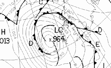 Met Office analysis chart for 0000 GMT on the 19th.
The 19th started mild everywhere, with further heavy rain in SW England and S Wales. The weather over S Ireland was mainly showery, but elsewhere rain fell at sometime during the day, heavy falls over parts of S England being followed by showers. The A470 at Cardiff was closed due to floods, and there was flooding on the A3 and A25 in Surrey. Elsewhere, there were flooded roads in many places in S Wales, the Midlands and W England. Sferics were recorded over SW Ireland later in the evening. (Saunton Sands 21C, Cardinham 11C, Bournemouth 45mm, Torquay 7.6h.)
The 20th was a mild and cloudy day everywhere. There were further falls of heavy rain, notably in S England, Northern Ireland, S Scotland and N England, with rain or showers in other districts, as an area of low pressure tracked from Cherbourg to NW Ireland during the day. Dublin reported a pressure of 980.6mb at 1800 GMT, and by early morning there was flooding in North Yorkshire and Sussex. 981mb at Dun Laoghaire was the lowest recorded in September in 11 years. Casement Airport had 45mm rain up to 0000 GMT on 21st and Dun Laoghaire had 32mm up to 0700 GMT on the 21st. Later in the day the Environment Agency issued yellow flood alerts for places in Wales, the Midland and SW England, and the A914 near Cupar was closed by floodwater in the afternoon. There were thunderstorms in parts of NE England during mid-morning, and later along a line from Kent to N England. At Coulsdon (Surrey) 40.6mm fell in 18 hours ending 1500 GMT, with heavy thunderstorms reported. Over the Forest of Dean a funnel cloud was filmed. (Jersey 21C, Pembrey Sands 9C, Kenley 58mm, Guernsey 5.5h.)
The low continued to move slowly NW over Ireland on the 21st giving a rather cloudy day in most places. There was widespread rain, heavy in places, over N Ireland and W Scotland, with gusts up to 40kn in places here. Thunderstorms occurred over parts of SE England and East Anglia during the late afternoon and evening. (Hastings 22C, Larkhill 7C, Hastings 33mm, Bournemouth 10.1h.)
The 22nd began cloudy in S England, ahead of a frontal system that pushed N across England and Waes during the day. This brought widespread rain and poor visibility, with thunderstorms reported over much of England, Wales and S Scotland, along with some some activity in S Ireland. In Cent. London torrential rain and thunderstorm with flooding brought visibility down to 300 metres at one point. Early patchy cloud over Scotland remained during the day; the best of the sunshine was in W Scotland, ahead of the cloud which affected S scotland later in the day. (Jersey 22C, Aviemore 8C, Hayling Island 29mm, Stornoway 10.8h.)
A S airflow on the 23rd brought bands of rain and showers to many parts of the British Isles. Thunderstorms were reported over W Ireland, Cent. S England and NE Scotland. (Coltishall 21C, Aviemore 6C, Lossiemouth 23mm, Tiree 8.1h.)
Further bands of rain and thunderstorms affected much of England and Wales on the 24th, while an area of low pressure remained centred near NW Scotland. SW Scotland and Ireland remained dry in places, although at Dun Laoghaire 7mm of rain fell in 20 minutesaround 1400 GMT. (Guernsey 22C, Altnaharra 7C, Pembrey Sands 40mm, Guernsey 7.6h.)
Winds decreased a little on the 25th, and there were some early morning fog pathes in S Ireland, Wales and SW England. Showers were again widespread, and thundery over SW England, SE Ireland and much of the Midlands and East Anglia as a shallow area of low pressure crossed from S Ireland to The Wash. A small tornado was reported on the Suffolk/Essex border. (Gravesend 21C, Hillsborough 6C, Coltishall 29mm, Falmouth 9.8h.)
The 26th was a generally cloudy day over the British Isles, although over Scotland a lack of cloud in places led to some ground frost. During the afternoon a slow-moving front brought rain to SW Ireland around lunchtime, and later to Wales, SW and Cent. S England. Thunderstorms were reported in parts of SE and E England during the afternoon, and around the coast of SE England during late morning. A waterspout was observed about 8 to 12 km offshore from Hastings from 1020 to 1025 GMT, beneath a very dark cumulonimbus cloud. (Poole 21C, Altnaharra 3C, Llanbedr 22mm, Bournemouth 8.7h.)
Another cloudy day on the 27th resulted from a slow-moving frontal system. This brought rain and showers to most parts of S Ireland, Wales and England during the day, with some heavy rain and thundery activity over SE England during late afternoon and evening. At Dun Laoghaire the stalled front gave 13mm in 1 hour, and the rainfall total for September so far, 135mm, now exceeds the previous highest there in 1976. (Herne Bay 20C, Biggar 4C, Folkestone 31mm, Stornoway 6.8h.)
A clearance in the W after the rain brought a ground frost to places in Cent. Ireland and Cent. Scotland by dawn on the 28th. There were also fog patches in parts of SW Scotland and N Ireland, although by dawn another area of rain had reached SW Ireland, pushing across most of Ireland, Wales and S scotland by midnight. There were a few showers over N and Cent. Scotland. (Guernsey 20C, Tulloch Bridge 2C, Eastbourne 12mm, Folkestone 8.1h.)
Low pressure on the 29th brought a mild SW airflow over S districts. In Ireland temperatures rose to 19C at Dublin and Belmullet. There were further spells of heavy rain and showers, with thunderstorms over N Wales and parts of N England, and over S districts of England, in both cases moving generally E. (Herne Bay 20C, Loch Glascarnoch 4C, Capel Curig 45mm, Cromer 8.1h.)
E-moving fronts and troughs, associated with low pressure over N areas on the 30th brought further rain and showers. It was cloudy in most places, and the best of the warmth was in S England. (Poole 20C, Shap and Wick 4C, Jersey 14mm, Cardiff 6.6h.)
Overnight, one man died when a fishing boat sank in gales off the Isles of Scilly. Gusts to 40kn were reported from many stations in Ireland, with 45kn in SW England. Later on the 2nd, one man died while trying to release floodwaters through a sluicegate in Herefordshire. Floodwarnings were issued for Herefordshire and Worcestershire; roads were 30cm deep in water in places. The A38 in Staffordshire was flooded. Around 0530 GMT a tornado affected an area just N of Slough for 6 seconds, reportedly being about 100m wide. By dawn an area of heavy rain had almost cleared SE England from the W, and the remainder of the day was mainly showery everywhere - some of the showers being thundery in S Ireland, SW England and Wales. Overnight, 30mm fell in about 6 hours at Solihull. Parts of Scotland experienced a ground frost under clearing skies. (Poole 17C, Aboyne 0C, Pershore 41mm, Oxford 9.2h.)
The 3rd saw more bands of showers affecting many parts of the British Isles, some of these being thundery in the NE Midlands and parts of S England. A small tornado was reported early in the day at Towyn, N Wales. A lively thunderstorm moved ESE across Nottingham, Ruddington village church was struck by lightning at 1344GMT and the church clock stopped at this time; small hail also fell in the storm. Heavy rain and hail also fell in Leeds during mid-afternoon. The wind slowly backed around to a N direction, with gusts to 40kn over much of N Scotland, and introducing cooler air to the British Isles. (Poole 18C, Eskdalemuir 2C, Loch Glascarnoch 24mm, Eastbourne 9.3h.)
An air frost occurred before dawn 4th over sheltered parts of Scotland in the cool NW airflow. There were some showers in coastal places exposed to the NW airflow, but in many places it was a dry and sunny day. Pressure rose to 1025mb in W Scotland later in the evening as a small anticyclone became established there. (Torquay 17C, Saughall -1C, Trawscoed 27mm, Morecambe 10.3h.)
Clear skies before dawn led to widespread air frost over S Scotland and parts of N England, Ireland and Wales on the 5th, with a ground frost in many other inland areas. Air pressure rose to 1030mb in Sussex by late evening, following a day that was mainly dry and sunny, except in Scotland where it clouded over later in the morning. At Dun Laoghaire the air pressure has risen over 40mb in less than 3 days, with the first ground frost of the autumn. (Guernsey 17C, Tulloch Bridge 9C max, Biggar -4C min, Coltishall 4mm, Littlehampton 10.6h.)
Clear skies overnight led to another air frost on the 6th in S Scotland and in N and inland areas of England and Wales, along with early fog patches over many parts of England. Cloud and rain spread to W Scotland overnight, and then pushed SE to affect most of Scotland and Ireland by midnight, while England and Wales remained dry with sunny spells. Air pressure again touched 1030mb, in parts of SE England and East Anglia during the morning. The frost hollow at Chipstead Valley recorded -2.8C, while the air frost at Reading University was the earliest in autumn since at least 1960. (Saunton Sands 19C, Redesdale -3C, Tiree 6mm, Guernsey 10.7h.)
The rain reached Wales and N England by dawn on the 7th, with lowest temperatures being in Cent S England before cloud spread to S England. During the day bands of rain and low cloud affected most areas of the British isles from time to time. (Great Malvern 17C, Bournemouth 1C, Tiree 15mm, Aberdeen 7.0h.)
The 8th was a generally cloudy day everywhere, with bands of rain and drizzle moving E during the day over Ireland, Wales and England, but being more persistent over Scotland. (Torquay 19C, Loch Glascarnoch 3C, Trawscoed 12mm, Teignmouth 4.8h.)
The 9th was another day of widespread cloud. A mild SW airflow led to some high overnight minimum temperatures, with 12 hour minima ending 0600 GMT including Valley 13.9C and readings above 12C in many places outside Scotland. Overnight, and during the daym there were further spells of light rain and drizzle, especially over Ireland and Scotland. (Margate 19C, Baltasound 4C, Buxton 12mm, Swanage 2.9h.)
The 10th also started with widespread cloud, and with light rain and drizzle over W Ireland and Scotland. Minimum temperatures included Preswick 13.5C, Ronaldsway 14.9C, Valley 15.0C, Cardiff 14.4C, Dun Laoghaire 16C, Long Kesh 14.7C, Casement 15.1C. The cloud persisted during the day in most places (although places along the E coast of England and Scotland saw the best of any sunshine) and light rain or drizzle fell in many areas at some time during the day. Precipitation over N Scotland turned showery later in the day, with hail seen at Stornoway and some sferics reported. (Herne Bay 21C, Baltasound 7C, Lusa 19mm, Cleethorpes 5.6h.)
The 11th began with a few showers (some with hail) over W and N Scotland, while an area of light rain and drizzle cleared S England by mid-morning. Elsewhere there was little overnight cloud, giving a ground frost in places. Showers fell over W coasts of Ireland and over W and N areas of Scotland during the day, although elsewhere it remained mainly dry with sunny spells with an area of high pressure becoming established over S Ireland. Around 1000 GMT slushy snow was reported at Alness, Ross-shire, while a gust of 61kn was measured at Fair Isle, as gusty conditions affected much of N and W Scotland. Air pressure rose to 1031mb in SW England, SW Wales and S Ireland by midnight. (Southend 17C, Shawbury 3C, Loch Glascarnoch 14mm, Aberdeen 9.5h.)
Small amounts of overnight cloud (except for extreme N and W districts of Scotland where there were a few showers) resulted in a ground frost in many sheltered places by dawn on the 12th, with a few fog patches from S Scotland to S England. Cloud cover over Scotland with rain moving E in the N; the remainder of the British Isles had a day of anticyclonic sunny spells. Pressure rose to 1032mb at times in S Wales and Cent. S England. (Saunton Sands 17C, Lerwick 10C max, Redhill and Chipstead Valley -1C min, Kirkwall 7mm, Falmouth 10.6h.)
High pressure again domintaed conditions on the 13th, with pressure around 1030 to 1031mb over the Midlands for much of the day. NW Ireland and Scotland had a mainly cloudy day with widespread light rain and drizzle, although it cleared later in the evening. After early morning fog patches in places from S Scotland to Cent S England, it was mainly dry and sunny over England and Wales, while Ireland had a sunny start with cloud spreading E later. (Aboyne 18C, Eskdalemuir 11C max, Redhill -1C min, Lerwick 13mm, Hunstanton 10.5h.)
Overnight cloud kept minimum temperatures generally above normal over Scotland, Northern Ireland and N England on the 14th, while there were scattered fog patches and some ground frost elsewhere. The British Isles then had a mainly dry day (although light drizzle and rainfell in parts of NE England and N Scotland), with sunny spells over Ireland, Wales Cent and S England; later in the afternoon cloud began spreading into SW Ireland and SW England. (Guernsey 18C, Spadeadam 11C max, Redhill -1C min, Newcastle 0.7mm, Anglesey 10.5h.)
A SE airflow led to a cloudy start along E coastal districts and over Scotland on 15th, while troughs brought precipitation to SW England and S Ireland. This pattern continued throughout the day, with the rain in the SW extending to S Wales and Cent S England by midnight; drizzle also fell over parts of E Scotland. (Anglesey 17C, Baltasound 3C, Isles of Scilly 17mm, Littlehampton 8.2h.)
Cloud persisted along coastal areas of Scotland, E and NE England for much of the 16th, due in part to a prevailing SE airflow. Troughs over Ireland, Wales and SW England resulted in cloud here, with some rain and drizzle and mist or fog (especially over Ireland). SE England and the Midlands was mainly sunny and dry, after some early fog patches. (Northolt 18C, Aviemore 0C, Teignmouth 11mm, Bognor Regis 9.2h.)
The 17th brought a misty start to much of Ireland, conditions which persisted until mid-afternoon in many places. N Ireland and Scotland had a cloudy start, with rain over N Ireland and SW Scotland, although during the day the cloud became mainly restricted to N Scotland. The remainder of the British Isles (except for the extreme SW England where it remained cloudy) had a day of sunny spells, after a ground frost in places. (Penzance 17C, South Farnborough 2C, Ballypatrick 7mm, Skegness 9.9h.)
Cloud cleared overnight from most areas of the British Isles, the exceptions by dawn on the 18th being parts of NE England, SW England and SW Ireland. There was a touch of ground frost in places, before cloud again extended inland to affect NE England E Scotland and much of Ireland. There was some light precipitation in NE England and N Ireland; elsewhere away from the cloud there were sunny spells in an E breeze. Across many areas of S Britain and Ireland the past two weeks have been quite dry - at Dun Laoghaire only 1.3mm has fallen in this period. (Torquay 15C, Aviemore -1C, Ballykelly 1mm, Bognor Regis 9.9h.)
The 19th saw a continuation of the cold E airflow over the British Isles. Many places had a sunny day, although SW England was cloudy at times, and there were several sharp showers in NE England, blowing in from the North Sea, giving an unpleasantly chilly, wet, dull day. Mainland Scotland was also rather cloudy with some rain in the SE, and gusts of 30 to 40kn were reported at times over costal areas of S England. (Guernsey 14C, Chipstead -1.4C, Newcastle 4mm, Ross-on-Wye 9.7h.)
Cloud persisted in places overnight along the E coast of Britain, and by dawn on the 20th an area of frontal rain had started to affect SE and Cent S England and the Channel Islands. This spread N during the day, with rain eventually reaching the N Midlands and Dublin. An E wind brought gusts of 40kn along the E coast, and with cloud and showers also affecting much of Scotland the best of the sunshine was in W Scotland and W Ireland. Over S parts of England (and in other areas) the rain kept daytime temperatures to 10C in places; in Ireland the air was drier, and at Dun Laoghaire strong crepescular rays were seen through stratocumulus. (Guernsey 15C, Buxton 7C max, Hawarden 1C min, Aboyne 9mm, Stornoway 9.1h.)
Much of England, Wales and Ireland had a damp day on the 21st as bands of rain moved N, introduing warmer air to S England by early evening. In many places in SE England mist, poor visibility and drizzle persisted for much of the day, although by midnight cloud had cleared from Cornwall. After mainly dry conditions overnight, E Scotland had a few showers before more general rain pushed N into S Scotland around midday, extending to all of mainland Scotland by midnight. Gusts to 45kn occurred in exposed E areas of Scotland. (Guernsey 16C, Buxton 7C max, Waterstein 5C min, Folkestone 17mm, Stornoway 8.9h.)
Overnight rain over Scotland, N Ireland, NE and E England moved steadily N on the 22nd, with warmer conditions moving with it. There were gusts to 50kn over N Scotland, and althogh a general clearance followed the rain there were further bands of rain and showers, especially over S England, later in the day. (London 17C, Lerwick 6C, Isle of Wight 35mm, Edinburgh 7.8h.)
Bands of rain and showers affected most areas on the 23rd, with gusts of 40kn occurring over exposed parts of N Scotland in the mild S airflow. Showers were thundery over most of England (except the extreme N and SW) during the afternoon. Later in the evening the wind increased over the Channel Islands, with gusts to 40kn. (Guernsey 18C, Colwyn Bay 7C, Southport 24mm, Bournemouth 7.0h.)
Weather on the 24th was dominated by the brisk N/NE movement of a deep low over E Britain, with widespread heavy rain and poor visibility over England, Wales and S Scotland. Pressure fell to about 971mb and there were gales in the E, with gusts to 50 or 60kn along exposed coasts in the SE (66kn was reported from Jersey). Other gusts included 55kn at Walton-on-the-Naze, Lee-on-Solent and Southend. Bognor Regis pier (a grade II listed structure) was closed after 20m of the pier was washed into the sea. Red and yellow flood warning were issued in Dorset and West Sussex. At Selsey, a caravan park was evacuated when floodwater rose to 18 ins depth. Thousands lost power in Sussex and Kent when power cables blew down. In East Sussex bushes were uprooted and conservatory windows blown in. Ireland remained mainly dry, with scattered showers. (extremes not yet to hand)
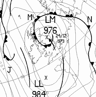 Met Office analysis chart for 0000 GMT on the 25th.
Overnight rain over England and E Scotland gradually became confined during the 25th to NE England and E Scotland, as the low remained slow-moving between Scotland and Norway. Pressure rose steadily during the day across much of the British Isles, and it truned brighter in W and S areas of Britain, with some showers over W coasts of Britain and Ireland in the N/NW airflow. There was some thundery activity over the E English Channel and Channel Islands during the evening. (Poole 18C, Redhill 4C, Capel Curig 55mm, Falmouth 9.2h.)
Pressure continued to rise during the 26th, with rain in E Scotland largely clearing by midday. Most of the British Isles had a day of sunny spells after the clearance of early morning mist and fog over Cent. S England. (Penzance 18C, Redhill 1C, Guernsey 9mm, Falmouth 9.2h.))
The 27th was a cloudy day over much of Ireland, Scotland and N England, with rain at times, this being particularly heavy and persistent in W Scotland. Clearing overnight skies in S England led to fog patches and ground frost in places there; most of England and Wales then had a sunny day. Gusts to 40-50 kn continued to blow over N and W Scotland, and NW Ireland; Belmullet reported 49kn at 1500 GMT as a cold front approached W Ireland. (Falmouth 18C, Bournemouth 0C, Isle of Skye 47mm, Penzance 9.4h.)
Clearing skies before dawn on the 28th over Northern Ireland and Scotland heralded a day of sunshine and showers here. There were fog patches over Cent. Ireland and Cent. S England around dawn, and light rain and drizzle in other areas of S England and East Anglia during the day; fog patches formed again by midnight over Cent. S England and parts of the Midlands. Most of Wales and N England had a sunny day. (London 19C, Castlederg 2C, Baltasound 15mm, Aberdeen 8.5h.)
There was widespread fog around dawn on the 29th over S Ireland, the Midlands, East Anglia and S England, which was slow to clear in places leaving mist in many areas for much of the day. Low minimum air temperatures occurred in places, with a slight air or ground frost. It remained cloudy in most places, with some precipitation over W and N parts of Ireland and Scotland and later in the day over S England. (Herne Bay 18C, Capel Curig -1C, Lerwick 2mm, Folkestone 7.2h.)
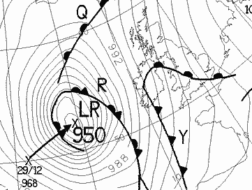 Met Office analysis chart for 0000 GMT on the 30th.
After early mist and fog in the Midlands and parts of S England, the 30th was cloudy in most places, with gales in exposed W districts as a strengthening airflow became established. Bands of rain spread quickly across the British Isles, associated with a strong cold front that resulted in a 5C temperature drop in 1 hour at Wigan, and gusts to 60 kn occurred in exposed W coastal districts (eg. 51kn at Malin Head at 1500GMT). At Dun Laoghaire air pressure fell 31mb in the 24 hours ending 06GMT on the 30th, following a night with a min temperature above 13C.
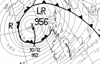 Met Office analysis chart for 0000 GMT on the 31st.
On the 31st a mild but showery SW airflow covered the British Isles, although more extensive rain affected W parts of Scotland and Ireland later in the day. Gales and gusts over 40kn were widespread in W districts, with a report of 63kn at Stornoway at 0900 GMT. 976.0mb was the MSL pressure at Stornoway at 0300 GMT. (Guernsey 17C, Aviemore 5C, Loch Glascarnoch 37mm, Margate 8.7h.)
The 2nd was a mainly day over England and Wales, apart from showers (including some hail in the SW) over W coasts. Over Ireland, after a bright start, it clouded over and a band of rain affected all areas during the evening; this also reached W Scotland. Most of Scotland had previously been rather showery in the W but sunnier in the E. (Guernsey 16C, Dyce 3C, Morecambe 10mm, Teignmouth 8.8h.)
Clear skies for a while overnight led to a slight ground frost in parts of S England by dawn on the 3rd, while there was some early light rain over parts of N and W Scotland. Cloud generally increased during the day, although there were some bright regions, with a SW gale in parts of N Ireland and Scotland (gusts to 50kn). There were showers on W coasts in the N at times during the day, while in the evening more general rain began to reach W Scotland. A tornado was reported to have ossurred in S Ireland. (Hastings 17C, Redhill -1C, Lusa (Skye) 5mm, Falmouth 8.7h.)
Slow-moving fronts resulted in some heavy rain with a gusty wind over W Scotland on the 4th, with 40mm falling at Aultbea in the 12 hours ending 0600GMT. Rain also affected the remainder of Scotland, Ireland and, later in the afternoon and evening, W districts of Wales and Cumbria. Clear skies before dawn led to fog patches in Cent. S England; Wales and England then clouded over during the day with some light rain in the extreme SW during the afternoon. (Eastbourne 16C, Redhill 3C, Aultbea 68mm, Jersey 6.8h.)
Weather on the 5th was dominated by the passage of frontal systems, giving heavy falls of rain in places (especially Wales and Cumbria), and squall conditions as a cold front passed. Gales occurred in SW England and the English Channel, with gusts to 70kn reported. Rain was particularly heavy in West Cumbria, with schools closing early after over 60mm of rain fell, making it (reportedly) the wettest day there for 60 years. Other parts of the county were significantly drier, however. Flooding was also noted in the Birmingham area, with 22.3mm falling at Cirencester (to the S). At Stubbington (South Fareham) a tornado occurred during the passage of a squall. Snow was visible above about 600m in W Cumbria, and hail fell in the Channel islands in the evening. (Jersey 15C, Loch Glascarnoch 4C, Capel Curig 62mm, Penzance 3.7h.)
Clearing skies and a NW airflow developed by dawn on the 6th, with rain becoming confined to NE England, although there were showers over N Scotland. It was quite windy in many areas until early evening, with a 20kn NW wind widely reported, along with showers on N and W coasts. Later in the evening there was light rain and drizzle in W Ireland. (Penzance 14C, Biggar 1C, Boulmer 23mm, Torquay 9.0h.)
Clear overnight skies under a weak ridge gave an air frost in places from S Scotland southwards on the 7th, although by dawn much of the W half of the British isles was cloudy with rain or drizzle. This spread E during the day to affect all districts, the precipitation becoming light in E England. (Torquay 14C, Aboyne -3C, Lusa 12mm, Folkestone 7.6h.)
The 8th was a generally cloudy day, although there were some bright spells in S and W parts of Scotland. Elsewhere there were spells of light rain or drizzle, this being most persistent in N Scotland. Pressure rose steadily during the day everywhere, 1039.3mb being reported at Malin Head by midnight. (Plymouth 15C, Lerwick 10C max, Aboyne 2C min, Lerwick 5mm, Stornoway 5.1h.)
A large anticyclone centred over scotland for much of the day domintaed the weather on the 9th, MSL pressure rising to 1045.7mb over Cent S Scotland by 2359GMT. Clear skies led to fog patches over parts of Ireland, N Wales and the Midlands, which persisted until mid-morning in some areas; at Drumburgh it remained for most of the day with a max temperature of about 5C. Most of the county had a dry day with sunny spells, except for light rain and drizzle at times in parts of extreme W and N Scotland. (Torquay 15C, Glasgow 5C max, Shap Fell 2C min, Baltasound 5mm, Fishguard 8.3h.)
The large anticyclone continued to dominate the weather on the 10th, with 1046.7mb at Aviemore (the highest reading ever in Britain in November). Early in the day clear skies eld to a frost in S Scotland and N England, with fog patches from N England to Cent S England. While most areas had sunny spells during the day, it was cloudy in N Scotland and light rain and drizzle fell in E and Cent S England. At Dun Laoghaire the pressure peaked at 1045mb at 13h, and has been above 1040 for more than a day (from 6h on 9th). The previous highest recorded pressure here in November was 1044mb on 30.11.80. (Falmouth 14C, Aviemore 7C max, Biggar -3C min, Folkestone 2mm, Falmouth 9.5h.)
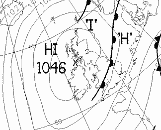 Met Office analysis chart for 0000 GMT on the 11th.
The anticyclone remained centred over the N part of the British isles on the 11th, with 1046mb over the highlands at 0000GMT. Much of Scotland and E Britain had a rather cloudy day with ligth rain and drizzle in parts of E England; in the W early sunshine was followed by cloudy skies, except for extreme SW England where it remained largely sunnny. (Guernsey 13C, Hillsborough 0C, Holbeach 4mm, Falmouth 7.7h.)
The 12th was cloudy in most areas, although there were some sunny spells in SW and Cent. S England, S Wales and East Anglia. Light rain and drizzle fell from slow-moving fronts over S England (before dawn), the Midlands and NE England, and there was some drizzle in parts of NE Scotland. (Cardiff 13C, Redesdale 2C, Cottesmore 7mm, Penzance 8.6h.)
The cloudy, anticyclonic conditions continued on the 13th, although there some breaks in the cloud in places. In Scotland there was air frost in some central areas, while the best of the sunshine occurred over SE England. There were fog patches around dawn over parts Cent. S England while over Ireland mist and drizzle affected many areas during the day. Drizzle also fell in many parts of E Scotland, and over E and Cent. areas of England and Wales at times. (Valley 13C, Tulloch Bridge -2C, Loftus 4mm, Bognor Regis 8.2h.)
The 14th was generally dull everywhere, with light rain or drizzle at times over many E and S parts of Britain, despite pressure still remaining above 1020mb almost everywhere. (Guernsey 13C, Saughall 0C, Rosehearty 7mm, Scarborough 3.1h.)
The 15th began cloudy, with fog patches in parts of S and SE Scotland. During the day a band of rain moved slowly SE over the British Isles (reaching as far as East Anglia and SW England) introducing a cooler NW airflow; over W and N Scotland there were showers of rain and hail, with gusts to 35kn being widespread. (Torquay 12C, Buxton 7C max, Barbourne 0C min, Lusa 8mm, Bognor Regis 8.8h.)
Overnight rain cleared East Anglia and S England by midday on the 16th, leaving the whole of the British Isles in a NW airflow. N and W coastal areas had showers during the day, these being of hail from N Wales northwards; showers were also blustery with gusts to 50kn in exposed parts of N Ireland and W Scotland. During the afternoon showers also affected S England, with thunder heard at Heathrow and Cent. London; thunder was also reported from the Lancashire coast before dawn. From 1517 to 1538GMT a thunderstorm with large hail occurred at Wokingham, the hail lying on the grass for at least an hour. At about the same time a tornado was reported from Weybridge, Surrey. There were also reports of snow from Sutherland (a good cover down to 500m, with heavy snow showers) and sleet over the Glenshane Pass in Northern Ireland. Satellite imagery showed the first significant snow cover of the winter over high ground in parts of N Scotland, Cumbria, the southern uplands and Northern Ireland. (Guernsey 12C, Tulloch Bridge 4C max, Aboyne 0C min, Ballypatrick 14mm, Torquay 8.1h.)
Clear skies before dawn on the 17thin led to an air frost in many parts of England and Scotland, although wintry showers in N Scotland resulted 1cm of lying snow early in the day at Fair Isle. Wintry showers fell along parts of the N and E coasts of England (as far S as Norfolk) and Scotland during the day, with gusts to 40kn in places, while thunder was heard in the Norfolk area. During the morning rain started falling over Ireland, and this pushed slowly SE into Wales and SW England later. (Penzance 11C, Lerwick and Aviemore 2C max, Fylingdales -3C min, Coltishall 11mm, Hayling Island 8.3h.)
Overnight rain cleared SW England, S Wales and S Ireland by midday on the 18th, while there was an air frost over clear parts of E and N England and E Scotland. During the day wintery showers fell down much of the E coast of England and Scotland with snow as far S as Lincolnshire, and thunder in E England, East Anglia and SE England. Snow also fell over high ground in Cent. Scotland and there were rain showers in parts of N and W Scotland. The cold NW wind was gusty along the E coast, with widespread gusts up to 45kn after midday.(Penzance 13C, Tulloch Bridge 3C max, Shap Fell -4C min, Colwyn Bay 17mm, Morecambe 7.4h.)
The 19th began clear in most places (with a sharp air frost in sheltered areas of S Scotland), except for some cloud in W Ireland and wintry showers along the E coast of England and Scotland. These showers gradually lessened, turning mainly to rain, while it clouded over in many areas (especially Scotland) during the day. There were a few thunderstorms reported from E England to SE England at varying times in the day, including an observation of a thunderstorm with snow before dawn in Norfolk. (Penzance 11C, Loch Glascarnoch 4C max, Saughall -5C min, Wainfleet 13mm, Exmouth 8.0h.)
The 20th saw air frost occurring in many parts of the British Isles, although cloud in the extreme N and W of Scotland resulted in a mild night there. There was some light rain and drizzle associated with this cloud during the day, while in parts of SE England showers of rain and hail occurred, accompanied by gusts to 40kn. Elsewhere, it was mainly dry with sunny spells. (Baltasound 10C, Perth and Kinloss 4C max, Biggar -5C min, Manston 16mm, Teignmouth 8.2h.)
N and NW Scotland dawned mild on the 21st; elsewhere the night was cloudy in E and Cent S areas of England but frosty in many other districts. In E Ireland there was a grass minimum reading of -2.5C at Dun Laoghaire, the culmination of 6 days of low temperatures. The SE movement of rain over Scotland and Ireland during the day heralded the arrival of warmer air which had reached S Scotland, W Wales and SW England by midnight. Remaining areas of the British Isles turned cloudy during the day, and there were some rain showers in SE England (Baltasound 10C, Eskdalemuir 2C max, Redesdale -6C min, Littlehampton 5mm, Fishguard 6.5h.)
The rainband introducing the warmer air continued to move across England early on the 22nd, to be followed by another band or precipitation which finally cleared the extreme SE by evening. Around dawn a temporary clearance in the cloud over Cent. Ireland did result in some ground frost there, although the day was rather cloudy in most places, with rain showers on W coasts of Ireland and Scotland. (Penzance 12C, Hillsborough 1C, Capel Curig 8mm, Newcastle 5.6h.)
The 23rd started damp and cloudy almost everywhere, with light rain in W Ireland and W Scotland and fog patches in Cent S England. It remained misty in parts of the S until midday, while rain spread to most of Scotland and Ireland , and also to N Wales, by midnight. (Torquay 14C, Lowestoft 9C max, Redhill -1C min, Sella Ness 21mm, Herne Bay 5.8h.)
A cloudy start everywhere kept minimum temperatures generally above freezing on the 24th, and most places then had a mild day. There was some light precipitation overnight in parts of S England, while a band of rain over Scotland and Ireland overnight moved slowly SE, giving 39mm at Tiree in 12 hours ending 0600GMT; this band reached Wales, the Midlands and part of S England by midnight, followed by showers over W and N Scotland. (Penzance and Torquay 15C, Saughall 1C, Capel Curig 50mm, Jersey 6.7h.)
Light rain continued to fall early on the 25th over S districts of England and Wales, eventually clearing the S coast around midday. During the afternoon an area of rain and gales began to affect W parts of Scotland and Ireland, the rain spreading across most of Ireland and Scotland, and across parts of Wales and N England by midnight. Gusts of 86kn at Aonach Moor, 78kn at Fair Isle and 60kn at Belmullet were reported during the evening. (Southampton 15C, Aboyne -2C, Llanbedr 27mm, Cromer and Hunstanton 5.9h.)
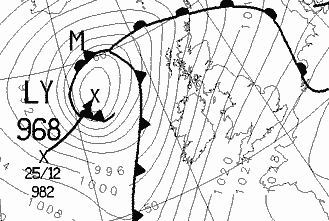 Met Office analysis chart for 0000 GMT on the 26th.
The wet and stormy conditions continued on to Known gusts into the 26th in N and W areas of the British isles, with gusts including 108kn at Cairngorm, 97kn at Aonach Moor, 74kn at Belmullet. Speed restrictions were imposed on the Severn and Forth Road bridges, and alter in the evening mean wind speeds of 50kn were reported from the Northern Isles. During the late morning and afternoon an active cold front crossed the British Isles, followed by heavy showers in W districts, including hail in W Scotland and NW Ireland. At Dun Laoghaire 6mm of rain fell under the front with the temperature falling from 12C (0800GMT) to 6C (1030GMT), accompanied by a sudden rise of pressure of 3mb in 30 mins. Thunder was heard in W Scotland later in the day. (Guernsey and Torquay 14C, Moyola 4C, Lusa 23mm, Herne Bay 4.1h.)
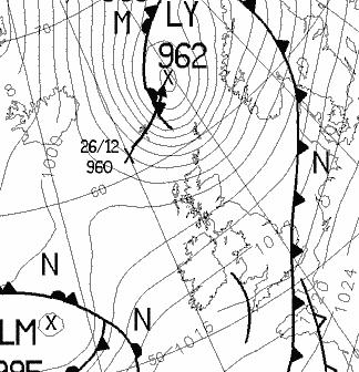 Met Office analysis chart for 0000 GMT on the 27th.
The cold front cleared SE England early on the 27th, with further bands of rain for a while in S England before dawn. Elsewhere the day started mainly dry (except for some showers in W Scotland and W Ireland); it clouded over in most places later as an area of rain pushed NE across Ireland and into Scotland, affecting Wales by midnight. The rain was heavy in places, leading to localised flooding in parts of Scotland (e.g. along the M74 near Abington), while strong winds again made driving difficult in parts of the NW with gusts over 50kn in places. (Guernsey 13C, Tulloch Bridge 0C, Stornoway 17mm, Margate 5.7h.)
The area of rain and gales steadily pushed NE during the 28th, with another cold front crossing much of the British Isles. There was heavy rain in parts of Ireland and Scotland, with some roads in Scotland being closed due to floodwaters. In Port Glasgow flood water reached the window sills of some homes, while Greenock was almost cut off because of flooding. Gales and gusts of 50kn were reported from SW England northwards ahead of the front; at Dun Laoghaire the temperature fell from 13C at 1500GMT to 6C at 1730GMT, with pressure rising 9mb from 1600 to 1900GMT. As the front spread E gusts to 40kn were widespread over much of England, and snow fell behind the front over high ground in Cent. Scotland and in the Northern Isles. (Torquay 14C, Lerwick 5C, Eskdalemuir 59mm, Herne Bay 2.9h.)
Early rain and drizzle over SW and Cent S England on the 29th persisted until the evening, clearing SW parts by midday and affecting the SE and parts of East Anglia from mid-morning onwards. Early precipitation over Scotland (including snow on the high ground) largely cleared by dawn, and there were frost patches there for a while. Apart from S England and a cloudy belt over S Scotland, the British Isles was mainly sunny until dusk, by which time an area of rain had reached Tiree, eventually to affect W Ireland and most of mainland Scotland by midnight. (Guernsey 14C, Loch Glascarnoch 1C max, Loch Glascarnoch -4C min, Aviemore 27mm, Leuchars 6.6h.)
A clear start to the 30th resulted in some air frost and fog patches for a while Cent. S England, before the area clouded over with widespread light drizzle later. Scotland, N England and w Ireland had a cloudy start with rain, heavy in places in Scotland. This rain area moved slowly S during the day, becoming weaker all the while. There were W gales over N Scotland early in the day, and these spread to most of Scotland and to N England by mid-afternoon. Gusts included 112kn on Cairngorm, 71kn at Kirkwall and 62kn at Malin Head. Several roads were closed to tall vehicles, and there was more flooding in parts of Scotland. Nacreous clouds seen over Scotland around 1515-1630GMT, and as far S as Cumbria. (Aberdeen and Prestatyn 15C, Benson -3C, Loch Glascarnoch 57mm, Jersey 6.6h.)
The 2nd began with rain showers over S Scotland and wintry showers over N and W parts of Scotland. More organised rain affected Cent. and S Scotland later in the day, with snow falling on the Southern Uplands. Cloud increased over Ireland from the W with a warm front bringing rain there during the evening, while there was patchy light rain over S England during late afternoon. Gusts to 30kn occurred over parts of S England during the afternoon with gusts to 50kn over exposed parts of Scotland. (Guernsey 14C, Wick 2C max, Lerwick -1C min, Tulloch Bridge 30mm, Eastbourne 6.1h.)
A deepening depression crossed S Scotland on the 3rd with gales to its S and N winds and snow following to the N. Gusts to 70 kn were reported across S Scotland and N England, and the pressure fell to 978 mb in the Firth-Clyde Valley around dawn. At Dun Laoghaire there was a 9mb fall in pressure in the three hours to 0000GMT accompanied by damaging gusts SW veering NW. Prestwick recorded a gust of 53 knots and a 6C temperature fall in 1 hour as the cold front passed. Heavy rain fell around the Anglo-Scottish border. The low dragged a cold front across all S areas of the British Isles, the rain finally clearing S England during the evening. Snow showers occurred as far S as N Wales and Shropshire, blocking several roads in the N and causing a spate of accidents. Thunder was reported in the showers from the Northern Isles to Cheshire. Three people died as a tree was blown down in Kings Heath, Birmingham. Strong gusts led to many blocked roads with fallen debris and overturned lorries in Scotland. Road restrictions were imposed in exposed areas as far S as Cheshire and Derbyshire. The A65 was flooded at Settle, and by evening 22cm of lying snow was reported at Aviemore. A gusts of 101mph was measured on the Humber Bridge, with 85mph at Crosby, and 75mp at Leeds (a December record there). (Eastbourne 14C, Aviemore 1C max, Aboyne -1C min, Shap Fell 58mm, Scarborough 3.9h.)
Skies largely cleared by dawn on the 4th, although wintry showers continued to fall over some W areas of Scotland and NW Ireland, and thunder was reported over in parts of SW Scotland. At Aviemore, blowing snow was reported at overnight. By dawn there was over a 30cm of lying snow in many parts of N Scotland and a light covering over most of the rest of Scotland, with powdery snow lying as far S as Staffordshire. 10cm was reported lying, unevenly, at Copley. Showers continued to fall throughtout the day, with snow in the N (being widespread as far S as the Midland counties) and rain further S, although skies generally cleared again in the evening. The M8 in Lanarkshire was barely passable due to snow in the morning, and the A635 at Holmfirth and the A6024 Woodhead Pass were closed by snow. One person died in Midlothian as his car skidded on black ice. Snowploughs were used to keep the M74 open, and four Scottish Premier League football games were cancelled due to snow or floods. The ski slopes at the Lecht and Cairngorm operated for the first time this winter. There was only a light covering but that was enough for enthusiastic skiers and snow-boarders. The Christmas tree in Glasgow's George Square was twisted and split by the gale force winds; workmen quickly replaced the original 35foot tree with another one brought from Aberfoyle and quickly redecorated the tree. (Penzance 10C, Spadeadam 0C max, Aviemore -6C min, Lerwick 22mm, Bognor Regis and Hayling Island 6.9h.)
The were further snow showers on 5th over N Yorkshire and as far S as Derbyshire before dawn, although by mid-morning warm frontal-rain was starting to spread W across Ireland. By midnight this reached all of Scotland, Wales, N England and SW England. Glasgow had four inches of precipitation this week (roughly equal to a month's average total) and the rain and warmer conditions caused a rapid thaw of lying snow. (Barra and Tiree 11C, Eskdalemuir 1C max, Loch Glascarnoch -8C min, Loch Glascarnoch 22mm, Margate 6.7h.)
After a mainly cloudy night the 6th dawned milder than of late. There was some rain and drizzle in S England and S wales for much of the day, before an area of heavier rain and drizzle in Scotland and Ireland moved gradually SE during the day reaching S England and East Anglia by midnight, introducing cooler, showery conditions in its wake. Some of these showers were accompanied by gusts to 50kn in W Scotland and Ireland. Some roads in Cent. Scotland remained flooded for most of the day by the early rain. (Hawarden 14C, Spadeadam 9C max, Fylingdales 2C min, Eskdalemuir 31mm, Kinloss 3.3h.)
Early rain over S England cleared by mid-morning on the 7th, to be followed by showers there. Bands of rain and showers affected much of the British Isles during the day, being heaviest in the W. Hail occured over Ireland Scotland, and snow fell on high ground in Scotland; 7mm diamter hail fell in a shower at Llansadrwn, amd almost covered the ground at 1430GMT. There were reports of thunder over parts of S and E England, and gusts to 45kn in places. Roads in Highland and Cumbria were reported to be flooded in places. (Guernsey 14C, Aviemore 1C, Glasgow 17mm, Newcastle 4.5h.)
A marked cold front crossed the British Isles on the 8th, part of a frontal system associated with a deep low that gave gales to W and N areas. Radar showed the front to be broken, with some places escaping much in the way of heavy rain. Some Irish Sea ferry services were cancelled earlier in the day, and reported gusts included 62kn Ronaldsway, 68kn Belmullet, 58kn Valentia. Pressure fell to 966mb in W Scotland late in the evening. A ferry from Larne in Northern Ireland was blown off course in gales and high winds as it approached Ardrossan harbour in Ayrshire. It ran aground inside the breakwater, shortly after midnight, being pulled free 11 eleven hours later. Patchy, thin snow cover was mainly restricted to high ground in the W areas of Cumbria, Scotland and Norther Ireland. (Guernsey 13C, Sella Ness 1C, Eskdalemuir 20mm, Belfast 3.7h.)
Low pressure crossing Scotland on the 9th brought frequent showers, and heavier spells of rain, over N parts of the British Isles (especially S Scotland and N England), and lighter showers elsewhere. With pressure as low as 966mb before dawn, winds were gale force over S Scotland and N England with gusts to 60kn in places during the morning. A cooler N airflow behind the low brought hail showers to the Northern Isles in the evening, and sleet was observed in a few places in Cent. Scotland. A few of the showers were thundery from SW England to N England. Parts of Kilmarnock town centre were under five feet of water after rivers burst their banks. Shoppers at a supermarket in Glasgow had to be rescued by emergency services using dinghies when flood water trapped them in the store. (Guernsey 11C, Altnaharra -3C, Shap Fell 46mm, Southend 7.0h.)
The 10th began with scattered rain and showers mainly over parts of Ireland and Scotland, and with an air frost in many areas of Scotland. During the day more organised cloud and rain spread NE across Ireland and into Wales and SW England by midnight, with some heavy falls in the SW. There wer some sleet and snow in Scotland, and a sharp frost after dark there as temperatures tumbled under clearing skies. (St. Mary's 12C, Loch Glascarnoch -4C, Cardinham 24mm, Folkestone 6.2h.)
Clear skies in Scotland early on the 11th soon clouded over except in the extreme N, and the day remained generally cloudy everywhere. Bands of rain, associated with a depression that crossed from N Ireland across S Scotland gave heavy falls in places. Malin Head reported a MSL pressure of 977mb at 1500GMT and there were gusts to 50kn across N Ireland and parts of N Britain. Snow and hail showers occurred early in the morning across N and Cent. Scotland to be followed by rain and sleet as the temperature rose slightly. The first 11 days of the month have brought 189mm to Windermere. (Herne bay 14C, Altnaharra -8C, Capel Curig 52mm, Lerwick 2.3h.)
Cloud over much of Britain led to a mild start to 12th except in N Scotland, and by dawn there were reports of flooding from S Scotland, Cleveland, Cumbria, the Midlands and Wales. Strong winds, rain and snow caused difficult driving conditions in N parts of Britain, while in Wales the River Severn burst its banks and thousands of acres were flooded. 10cm of snow was reported to have fallen in Cent. Scotland. Thundery showers occurred in SW England where hail was also observed. (Jersey 10C, Altnaharra 0C max, Altnaharra -6C min, Capel Curig 47mm, Torquay 3.6h.)
The 13th started with a band of rain and snow across S Scotland and N England, and a widespread frost in other parts of Scotland; the M74 in Lanarkshire was down to one lane due to snow cover. Fresh snow fell on the mountains of Snowdonia overnight followed by further falls in the morning giving moderate falls on the summits and slight falls as low as 1000ft in places. Cloud and rain began to affect SW Ireland and SW England before dawn (with hail and thunder in Devon), pushing NE into the Midlands and Cent. Ireland. Heavy warm sector rain fell in places, and there was heavy snowfall in Wales and Shropshire (where schoolchildren were sent home early as a result). As the rain moved E, snow fell on the N limits of the warm sector/low in the Midlands, S Pennines and East Anglia, to be followed by wintry showers and cooler conditions over Ireland, Wales and SW England. Parts of Scotland remained below freezing all day, and snow showers fell in N parts of the country. The Snake Pass was closed with 15cm of lying snow reported, while Stornoway reported thunder in the evening. At Coventry Bablake the first air frost of the autumn/winter occurred at 2000GMT - the latest such event since records were first kept in the city in 1892. (Jersey 11C, Biggar -3C max, Tulloch Bridge -7C min, St Athan 24mm, Newcastle 4.6h.)
The 14th dawned with showers of snow and hail over Scotland and Northern Ireland, freezing fog over S Scotland and parts of N England, some icy roads in SW England after rain fell on cold surfaces, and a widespread air frost. The Snake Pass in the Pennines was closed. During the areas of wintry weather moved generally S over England and Wales, with hail showers in SW England and sleet and snow reaching the Midlands, SE and Cent. S England by midnight. Thunder was reported in NE England in the evening. 6,000 children in Lanarkshire got an extra day's holiday when 10cm of snow fell in less than four hours. Traffic on the motorway between Glasgow and Edinburgh was badly affected as blizzard conditions affected the road at its highest point. Roads in the north were also badly affected. (Penzance 9C, Buxton (Derbyshire) 0C min, Biggar -10C min, Aviemore 12mm, Hayling Island 7.2h.)
Early sleet/snow fell in NE England, Lincolnshire and at Heathrow before dawn on the 15th, with wintry showers in N and NE Scotland also; 0600GMT snow depths included 13cm Aviemore and 8cm at Eskdalemuir, with the A93 closed at the Spittal of Glenshee and the A939 Cockbridge to Tomintoul road also shut. Thunder occurred over Yorkshire around dawn. Much of Ireland, Wales and S England (away from the E coast) had a sunny day, although there were some rain showers in Ireland. Wintry showers fell as far S as the Midlands and Essex, while in Scotland there were rain showers in the W, and sleet or snow in the E and on high ground. In S Wales falls of 10cm resulted in disruption on the higher-level roads. The N wind was fresh at times, with gusts to 40Kn along E England. (St Mary's 9C, Spadeadam 0C max, Biggar -8C min, Leconfield 12mm, Teignmouth 7.2h.)
Parts of S England had a brief air frost before pre-dawn cloud on the 16th lifted temperatures; elsewhere there were some snow showers in NE England and rain showers in W Ireland and W Scotland before dawn. During the day, a freshening wind and cloud cover from the W in all areas was followed by rain over Ireland and Scotland. Gusts to 40kn were widespread during the evening, with 56kn reported at Malin Head at 2100GMT; pressure was falling at the rate of over 9mbar in 3 hours over parts of N and W Scotland from 1800 to 2100GMT. (Penzance 10C, Benson -3C, Loch Glascarnoch 18mm, Torquay 5.8h.)
Rain over N and W parts of the British Isles moved slowly SE during the 17th, becoming slow-moving over S Ireland and S England during the afternoon and evening. Skies cleared in the N as the rain passed, with wintry showers falling over Scotland. There was also a widespread frost over Scotland and N England by midnight. (Pershore 13C, Redhill -1C, Capel Curig 49mm, Scarborough 6.1h.)
The 18th began with clear skies over Scotland (apart from a few wintry showers in places) and a widespread air frost over Scotland and N England. Rain continued to fall in parts S Ireland, S Wales (where there was snow on higher ground), SW and Cent. S England before dawn. During the afternoon heavier rain began to affect S Ireland and S Wales, as a depression tracked E into the English Channel; this turned to snow over the Mendips and high ground in S Wales later in the afternoon before moving E into the Chilterns, Thames Valley, Sussex and W Kent areas (with smaller falls or sleet in neighbouring areas). In Cornwall and Devon the precipitation remained in the form of heavy rain. A band of sleet and snow affected S Scotland and extreme N England for much of the day, while snow showers feel further N. At Cirencester slight rain in the afternoon turned to moderate snow by dusk. Rain turned to sleet and snow around 1500GMT at Bristol Totterdown; temperature fell from 4.5C to just above 1.0C, then at about 1900GMT snow turned back to rain for about 1 hour after which moderate snow fell until 2300GMT. 23mm fell at Uplyme (East Devon) in the 24 hours from 0900GMT, with 50mm at Redruth in 24hours to 1800GMT. (Guernsey 13C, Loch Glascarnoch -2C max, Altnaharra -7C min, Falmouth 50mm, Hunstanton 6.9h.)
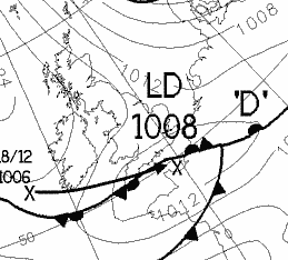 Met Office analysis chart for 0000 GMT on the 19th.
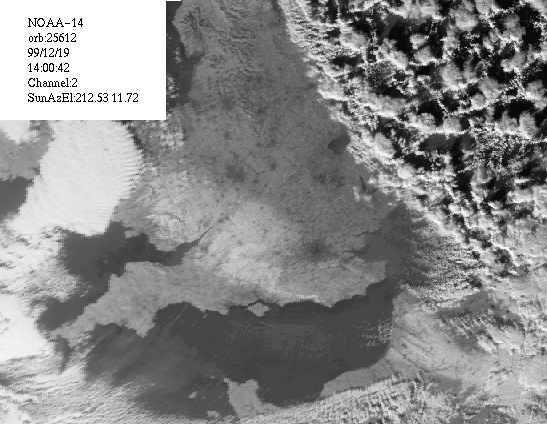 Showing snow cover at 1400GMT on the 19th.
The precipitation cleared SE England before dawn on the 19th; the British Isles then had a mainly clear, cold night but with further wintry showers in N and Cent. Scotland. These continued during the day, extending down the E coast of England to Yorkshire. Elsewhere, it was a day of unbroken sunshine, although in many places it remained below freezing in a cold NW airflow. Snow depths included 10cm at Chippenham, 9cm full cover at Cirencester (with a grass minimum (over snow cover) of -11.7C, air minimum was -4.7C), 4cm at 35m altitude in Bristol and 3cm at Chipstead Valley (minimum -10.6C). Other minima included -8C at Topcliffe (N Yorkshire, -14C on the grass). By early morning some Welsh valleys were impassable after over 15cm of snow fell, and 50 vehicles were stranded on the A470. Across much of the S wet lying snow and rain froze during the night as temperatures dropped; 1 person died after a crash on the M4 near Newbury caused by the ice and 2 died in Oxfordshire. 90 homes were flooded in Cornwall (there were flood alerts across Cornwall, Devon and Somerset), while in Sussex the A29 was impassable due to snow at Bury Hill. At Dun Laoghaire, the maximum of 3.6C was the lowest since January 1997. (St. Mary's 8C, Spadeadam -3C max, Biggar -13C min, Falmouth 39mm, Bristol 8.2h.)
With patchy cloud and a S wind developing over Scotland early on the 20th, the morning was coldest in S England; minimum temperatures included 13C Ross-on-Wye, -12.7C at Hungerford, -8.6C at Drumburgh, -8.3 Wigan, and -9.8C at Stratfield Mortimer (S or Reading) (this is the lowest air minimum in the Mortimer/Stratfield Mortimer area since 12 December 1991). At Cirencester the minimum was -10.4C (-14.5C on the grass), rising to a high of -1.9C. At Weston Coyney (Stoke) -8.5C was the lowest reading since January 1987. Temperatures starting rising rapidly in Cornwall and SW Ireland shortly after dawn, and cloud spread rapidly E to reach much of England by midday. Showers of sleet/snow fell in N scotland during the morning, and rain with gusts to 50kn reached SW Ireland. The rain pushed E for the remainder of the day, falling as snow in parts of W Scotland and Wales by midnight. (St Mary's 8C, Redesdale -5C max, Sennybridge -14C min, Baltasound 4mm, Clacton 6.3h.)
The band of precipitation continued to push across the British Isles on the 21st, falling as freezing rain in the Wirral before dawn, as rain in the SW and as sleet and snow in most other places. Snow was measured at 4cm deep in Wigan. Traffic was disrupted from S Scotland to the Midlands, and Glasgow Airport was closed for a while. The precipitation cleared most of England by mid-afternoon, although light rain and drizzle lingered in parts of SW and Cent. S England, leading to fog formation in places. Warmer weather followed the rain and snow, and although some places had a sunny end to the day, fog formed during the evening from NE England to the SW (probably a result of warm air coming in contact with a cold surface). Further rain reached Ireland and W scotland by midnight. (Penzance 13C, Perth and Kinloss 0C max, Aviemore -9C, Penzance 19mm, Prestatyn 5.7h.)
The 22nd was unusually cloudy over almost the entire British Isles - possibly the dullest day of 1999. Slow-moving fronts and troughs crossed during the day, with precipitation falling everywhere; clearer, showery air pushed into Ireland during the evening from the W. Gusts to 50kn were reported from Ireland, Scotland, Wales and SW England in S gales. (Chivenor 14C, Redesdale -1C, Tulloch Bridge 49mm, Jersey 0.1h.)
Rain cleared E England by dawn on the 23rd, leaving the British Isles in a showery W airflow. These showers fell as sleet or snow over high ground in N Scotland with some hail at lower levels, and thunder was reported from Tiree during the morning. Gusts to 50kn were reported from W districts. Later in the morning an area of cloud and rain reached NW Ireland, and pushed rapidly E and N to affect all but parts of SE England by midnight. Gales were reported from Scotland and N Ireland, with Malin Head reporting a 68kn gust at 1800GMT, later spreading to most coastal areas of England. (Falmouth 13C, Redhill 0C, Loch Glascarnoch 31mm, Clacton 6.2h.)
The 24th was windy everywhere with a large and deep area of low pressure close to, or over, N Scotland all day. A deepening low resulted in MSL pressure falling to 948mb at Aberdeen by midnight with very strong winds to the S; gusts of over 100mph were reported to have occurred. At Corsock 951.5mb was recorded, the lowest in 10 years of records, while at Ferryhill a pressure fall of 15.6mb was noted between 1700 and 2000GMT. Bands of precipitation affected most areas from time to time during the day although snow fell only on the higher peaks in Scotland, mostly following the passage of the low. The rain was heavy in parts of S England (including 27mm at Cholesbury on the Chilterns), especially the SW. From Kent to Hampshire S gales, coupled with an unusually short distance between the moon and earth, led to some of the highest tides in living memory. By the end of the day over 50 rivers in Devon and Cornwall were on a yellow flood alert. The River Dart burst its banks and one man died in Galmpton, Devon, and a freak wave in New Brighton swept one man to his death into the River Mersey. In Co Down many coast roads were flooded while in the W part of Northern Ireland lightning strikes led to some power cuts. At Langtoft a thunderstorm occurred at 2130GMT, this being accompanied by a couple of power cuts, and thunder was also heard in the Midlands and Lincolnshire. (Chivenor 14C, Aviemore 2C, Cardinham 59mm, Aberdeen 4.2h.)
By dawn on the 25th the sea defences had been breached in several parts of Sussex. 6 people were airlifted off a ship near NE England in force 11 winds, while 400 homes were without power in East Anglia. In Oxfordshire the River Evenlode burst its banks in places. The day began in Scotland with blizzards being reported, as the low near Aberdeen moved N, still deepening. Showers and strong W or SW winds affected most of the British Isles during Christmas day, the showers being thundery in places (with hail at Wigan). In Coventry a thunderstorm with hail around 0040GMT led to lying hail for over 2 hours. Wintry showers were widespread over N and Cent. Scotland (where 50kn gusts occurred during the morning) and a passing trough gave snow showers as far S as Cork and Hampshire. Snow fell on the London Weather Centre, and bookmakers who had been offering 50-1 odds two days earlier against snow stood to lose hundreds of thousands of pounds. During the evening heavy snow was reported in parts of East Scotland, while in Ireland snow lay on hills above 130m outside Dublin. (Guernsey 12C, Lough Fea 0C, Lossiemouth 33mm, Newcastle 4.3h.)
Parts of Scotland had a frosty start on the 26th with showers of snow/sleet in places. Showers developed during the day, especially in N and W parts of the British Isles, while there was more extensive rain over parts of S England before dawn. Hail fell as far S as Valentia and Cornwall, with snow observed over N Wales; a light covering of snow occurred in Stoke-on-Trent during the morning. At Copley snow lay 7cm deep at 0900GMT. Thunder was heard over Ireland, the Wirral and S England. In N Somerset, thunderstorms during the day were accompanied by hail, rain and snow. (Torquay and St Mary's Scilly 10C, Aboyne -2C, Eastbourne 41mm, Clacton 4.8h.)
The 27th began with a NW airflow over the British Isles, but during the afternoon a deepening low crossed N France and winds in S England became E for a while. After a widespread ground frost, showers again affected mainly W areas with snow falling in Cent. Scotland. Hail and snow fell as far S as Cork, while at 1800GMT Guernsey reported heavy rain after recent snow, and MSL pressure of 987.5mb. Thunder was reported over part of the English Channel, while there was also extensive flooding on Guernsey. (Guernsey 9C, Redhill -2C, Jersey 25mm, Cleethorpes 5.1h.)
A NW airstream on the 28th brought an air frost to many places before dawn, although in S England and in some W districts cloud and showers kept temperatures up. Snow fell as far S as the Midlands before dawn, although much of the day was dry in most areas. Road reports at dawn included those of ice on many roads in Scotland, S Wales and SW England. During the evening clearing skies, heralding another widespread air frost. (Torquay 8C, Spadeadam 0C max, Leeming -5C min, Falmouth 17mm, Weymouth 7.1h.)
Cloud increased by dawn on the 29th over Scotland and parts of N Ireland with showers of snow in parts of W Scotland. Over England mainy clear skies led to a widespread frost, with some sleet showers in the Midland before dawn and freezing rain at Chalfont St. Giles at 0900GMT. Parts of the A16 in Lincolnshire and the A47 in Norfolk were closed after black ice caused accidents. It remained bright in most places except for N Scotland by day, with further rain showers on some W coasts, although during the evening more organised cloud and rain spread E to W parts of Ireland and Scotland. (Guernsey 10C, Topcliffe -6C, Loch Glascarnoch 15mm, Clacton 7.1h.)
Cloud and rain spread across the British Isles on the 30th, although parts of SE England had a sharp frost before the cloud arrived. During the evening fog formed in parts of S Scotland and N England. (Culdrose 11C, Redhill -4C, Llansadrwn 26mm, Stornoway 1.7h.)
The 31st dawned damp and mainly cloudy with fog in many parts inland and N England, while frost n Scotland led to some icy roads there. It remained mild, damp and cloudy in most places all day, with further bands of rain spreading across the British Isles and gusts over 40kn in parts of NW Scotland. During the evening skies largely cleared over Ireland and Scotland. (St Mary's 12C, Aboyne -3C, Lusa 12mm, Prestatyn 1.5h.)