Tuesday 4th March
A
Bad Day To Visit Norden Trondelag!
Weather Outlook: Quietening down here the next few days
Flight plan for tomorrow: No
flight
Blog
Like I said
in the title, if you chose to visit Norden Trondelag or nearby
Polar low centre Andøya, where we are located
![]()
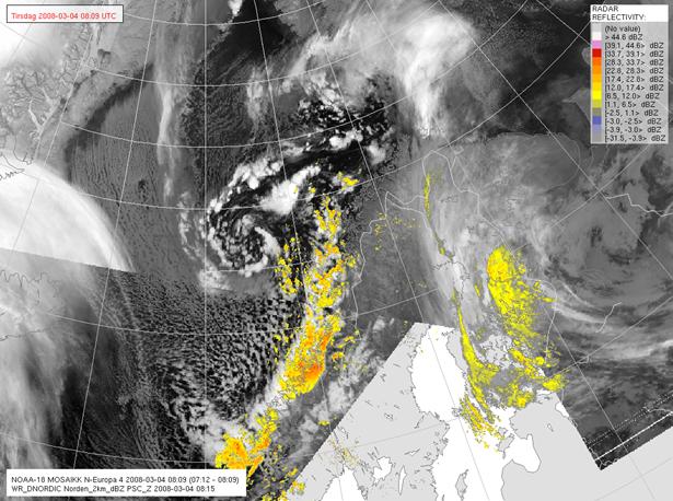
 The polar low as seen on infra-red
satellite images at 8am this morning, with associated rain bands.
The polar low as seen on infra-red
satellite images at 8am this morning, with associated rain bands.
Today’s
activity at HQ was centred around the polar low. The latest satellite images and radar were
carefully monitored, as were the soundings when they became available. It became clear during the day that the polar
low was moving slower than the models had predicted and deepening more as it
moved over the warm ocean currents near the coast. It was moving more to the left than forecast,
looking like it might make landfall later and slightly further up the coast
than had been forecast.
The down
day tomorrow gives everyone a break and a chance to rest after all the activity
of the previous week. In celebration of
the successful flights, and because there was no need to get up early the next
day, a small party was planned for the evening, with desserts being prepared by
Andreas and Vanda. Erik arrived just in
time to join the party, bringing photos of the polar low that he had flown over
on his flight from Longyearbyen (Spitsbergen) to mainland
Weather Round-up
Polar low
tomorrow at midday is at 73N, 8W, just north of Jan Mayen. This small feature merges with the large
synoptic-scale cyclone that hits
SAP Evaluation
The ETKF
SAPs for all optimisation times highlight the northern edge of the low pressure
system that is developing and moving towards
The SV SAPs
also highlight this low pressure system as sensitive, and have some overlap
with the SVs. The SVs for 12hrs
optimisation indicate that the southern and eastern parts of the low pressure
system are most sensitive. For 24hrs
optimisation the eastern and northern parts of the low pressure system are more
important. This region is also highlighted
by the 36hr SV SAPs, as well as a region over Greenland, where the upper-level
flow is coming from.