


Last update
17 Sep 2001

This page is maintained by
Mark Fielding
All content Copyright © The University of Reading unless otherwise stated.
Dual wavelength radar measurement of stratocumulus liquid water content
Robin Hogan, Anthony Illingworth, Suzanne Jongen, John Goddard and Henri SauvageotIntroduction
- One of the main problems in using radar to make quantitative measurements of stratocumulus is that the occasional large drizzle droplet (around 100 microns in diameter) can produce a large signal for the radar but contribute negligibly to liquid water content (LWC). Analysis of 3 months of data taken during the Cloud Characteristics campaign indicates that more than half of the stratocumulus over Chilbolton contains drizzle.
- However, attenuation is proportional to LWC and increases with frequency, so two colocated radars at different frequencies should be able to measure LWC by taking the dirivative with height of the Dual-wavelength ratio (DWR).
Comparison with microwave radiometers
- During the CLARE'98 campaign at
Chibolton, three ground-based cloud radars were available. These were
the 35 GHz Rabelais, the 94 GHz Galileo and the GKSS 35
GHz Miracle. In addition, a number of microwave radiometers were
available which could be used to derive the vertically-integrated
liquid water.
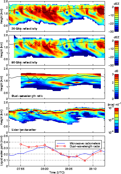
- The figure above shows time-height sections of radar reflectivity measured by the Rabelais and Miracle radars on 20 October 1999, together with the dual-wavelength ratio. The first glance would suggest that DWR is too noisy to attempt taking a vertical derivative.
- However, lidar backscatter coefficient in the fourth panel shows that cloud base is actually quite high, and the bulk of the radar signal is actually drizzle falling out of the cloud. The noise in DWR can then be explained as being due to Mie scattering by large drops, but while the (mostly) monotonic increase in DWR in the upper 300 m of the signal that is cloud is due entirely to differential attenuation.
- The differential attenuation has been used to calculate liquid water path, which is shown by the red line in the lowest panel. The effect of water vapour attenuation has been subtracted using the temperature and pressure from the UK Met Office model analysis. The agreement with the values obtained by the microwave radiometers is excellent, indicating the potential of the technique.
Profiles of liquid water content
- The next step is to calculate the actual profile of LWC from the
derivative of DWR with height. An example of the profiles that can
be obtained by dual wavelength radar is shown below.
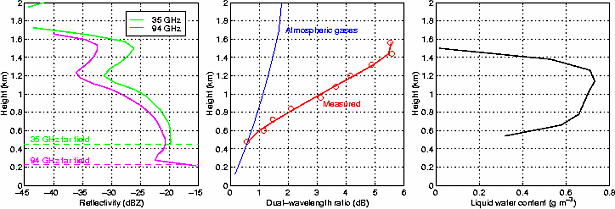
- This is much more difficult to validate because stratocumulus is very inhomogeneous and so exact coincidence with in situ aircraft measurements must be achieved.
Reference
- Cloud characteristics from dual wavelength millimetre-wave
radar
Hogan, R. J., A. J. Illingworth and H. Sauvageot, 1999, Proc. 29th Int. Conf. on Radar Meteorol., Montreal, Canada, 457-459. (Download diffatten.ps.gz)
See also...
- Dual-wavelength measurements in cirrus.